
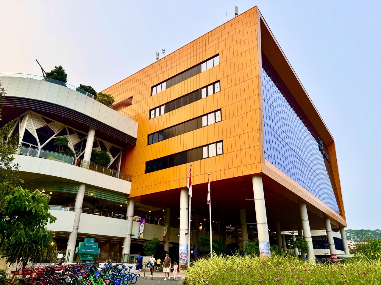
One Punggol is easy to recognise from its bold facade, high open roof and large public-facing name. Finding the precise facility you need inside is a different task. Our new October 2026 photographs show a bright yellow architectural feature, the open public roof, the building’s entrance and the Punggol Regional Library presence. For a first-time visitor, these are excellent landmarks. But a community hub with many different services needs more than one recognisable facade: it needs good wayfinding.
The useful facts are these: One Punggol is at 1 Punggol Drive, Singapore 828629. The People’s Association describes it as an integrated lifestyle hub, a ‘place of many places’ with nine co-location partners offering civic, learning, community, food and care services. That means the exact floor, room and access route depend on what you are visiting. This photo-led guide explains how to think about landmarks, information signs, paths and meeting points without inventing a floor directory or claiming that a photographed entrance is the only usable entrance.

One Punggol wayfinding: quick facts
- Address: 1 Punggol Drive, Singapore 828629, as listed by the People’s Association.
- What it is: a co-located hub for community, public-service, learning, food and care activities—not a single-room building.
- What new photos show: a yellow facade feature, large open roof, entrance views, the library and nearby public paths.
- Common first-time problem: reaching the right building but not knowing which floor or designated entrance belongs to a particular appointment.
- Better meeting instruction: full building name, the specific facility, a current signed landmark and an agreed public meeting area.
- Accessible approach: use current lift, ramp and path information relevant to the visitor, rather than assuming a visible staircase suits everybody.
- Children with scooters: a photo records activity, not permission to ride every type of device everywhere in the hub. Check present path markings and site rules.
The most reliable starting pages are the People’s Association’s One Punggol Overview, Hub Info and facilities and official address. For moving between facilities, follow the physical building directory. To learn the building’s architecture in depth, visit the separate One Punggol high-roof photo walk; this article focuses on the visitor’s information journey.
A destination and an entrance are different pieces of information
An address establishes where a building is, but not necessarily which entrance, lift or floor is right for a service. At One Punggol, that distinction matters because the library, community club, hawker centre and other agencies occupy different parts of a large integrated complex. A visitor can arrive at 1 Punggol Drive and still need to make another decision before reaching their appointment.
A useful message therefore includes the intended facility rather than just the building name. ‘Meet me at One Punggol’ leaves too many possibilities. ‘Meet at the appropriately signed entrance for our appointment, then go to the named facility’ is more practical. Where the visit is scheduled, check the organiser’s room or floor details as well. The exterior photograph does not supply an official internal route.
What the yellow facade can do—and what it cannot
The bright feature in our October photograph makes the building visually memorable. A striking colour can be a powerful landmark when a family is approaching from a road or LRT-connected path. A child who recognises the building may feel more confident about being in the right neighbourhood. That is useful, but it is only the first layer of wayfinding.
A photograph’s colours depend on lighting, perspective and camera processing. Nor does every doorway necessarily share the same facade treatment. The practical instruction is to use the exact address and building name, then the signboard or directory for the correct facility. ‘Follow something yellow’ is not an adequate route for a person arriving from an unfamiliar direction.
The idea of a ‘place of many places’
The People’s Association describes One Punggol as an integrated lifestyle hub with nine co-location partners. They include a Community Club, regional library, hawker centre and several health, care and government-service facilities. The concept is more than gathering signboards in one structure: residents can access different kinds of services within a common precinct, which can reduce unnecessary travel when visits are coordinated sensibly.
But co-location creates an information challenge. A library visitor may be thinking about borrowing books while somebody else seeks a government counter or a care appointment. Their destination inside the building differs, even when both begin from the same road. Wayfinding needs to help each person translate a broad address into a precise public route.
Why signs must work at several levels
Consider a journey to a large hub. At the city scale, you need to find Punggol and the correct transport connection. At street level, you need the building. At the entrance, you need the floor and room. Finally, you need to recognise the actual service counter or activity space. A sign that is useful for one layer may not answer the next.
This is why a facade and a directory should be treated as complementary rather than interchangeable. The building name confirms identity; the directory resolves internal destinations; individual room signage confirms arrival. An article can explain this information hierarchy without reproducing a floor map that might become outdated.
A recognizable roof is a landmark, not a guarantee of weather protection
One Punggol’s high roof gives the complex a distinctive public-space character, visible in several new images. It can help people recognise that they have reached the right development. But the presence of overhead cover in one photograph does not mean every crossing, staircase, lift lobby or walkway on the journey is sheltered against all rain.
For a family in wet weather, plan the route and carry appropriate protection where needed. If a section is closed or a temporary route is posted, follow it. The roof is an architectural feature; the current pedestrian signs are the authority for movement. Treat those as different kinds of information.
How a first-time visitor should begin on arrival
Reach a lawful public pedestrian entrance and step aside where it is safe to consult the building directory. Identify the exact facility, floor and route before heading up or down. Do not stop a family directly at a busy escalator landing to decide where to go. People with food trays, strollers and mobility aids need space to pass.
If the directory is unclear, ask staff or use the relevant agency’s current instructions. Guessing may send the group across several floors unnecessarily. A little orientation at the beginning is especially useful for someone who does not visit large mixed-use buildings often.
Why building directories can be better than maps on phones
A phone map is excellent for reaching 1 Punggol Drive, but it may not contain an up-to-date, detailed record of internal rooms, temporary closures or the correct service counter. The current directory and facility signage serve a different purpose. They help the visitor choose a route inside an active public building.
Parents can show children how to move from a general map to a local directory. ‘The app brought us to the building; now let’s find the library sign.’ That is a clear and transferable skill. It also reduces the temptation to wander through restricted corridors because an internal map looked incomplete.
The regional library is a particular destination within the hub
The October photo set includes Punggol Regional Library. NLB manages the library, but the People’s Association manages the broader hub context. Those are separate institutional roles. A person going to borrow a book needs the library’s current opening information, not the operating hours of the community club or hawker centre.
This is an important wayfinding habit: identify who runs the service. A single building can contain multiple agencies with their own programmes and rules. Use the dedicated Punggol Regional Library guide for borrowing, study and children’s spaces; use the hub directory to find the appropriate route.
The hawker centre is not a general waiting room
The Level 2 hawker centre is one of One Punggol’s familiar destinations. People arrive to eat, collect food and use shared dining tables. It has a different operating rhythm from a library or appointment counter. Don’t tell a group to meet at an unspecified hawker table for an extended non-dining activity, especially during a busy meal period.
If the party is actually having lunch, agree on a safe meeting plan that doesn’t block ordering aisles or tray-return areas. Our Level 2 hawker-centre photo guide owns those practical dining details. This article focuses on getting to the right facility in the first place.
Why government and care appointments need more precise instructions
One Punggol contains public-service and care facilities among its co-location partners. These visits may involve an appointment time, personal documents or specific registration steps. A broad photograph of the facade is not sufficient evidence for which counter to approach or what information to bring. Visitors should use the responsible agency’s actual appointment instructions.
Personal data should also be handled carefully. There is no need to post a medical appointment, personal identity number or detailed case information into a public chat simply to tell a family member where to meet. Share only the practical route details needed for assistance, using a private channel.
A family with young children needs a realistic sequence
Children may be happy to recognise a bright building but tire quickly when adults move up and down searching for a room. Before arriving, decide the visit’s main purpose, confirm the destination and allow time for toilets or a pause if needed. A short and predictable plan is often more comfortable than an ambitious circuit through every facility.
For an adult supervising two children, avoid splitting the group casually across floors. The exact arrangement depends on the children’s ages and abilities. A better plan may involve finishing one appointment together, then deciding whether a second activity is practical. Wayfinding should reduce pressure, not create a race through the hub.
An older visitor may prioritise lifts and places to pause
A visitor who cannot stand or climb comfortably may require a different internal route from someone moving freely. Ask about preferences rather than assume that all older adults need the same support. A photograph showing a staircase and large roof cannot prove there is a usable step-free path to every service.
Current lift and ramp signage, as well as staff guidance, is the right source for a specific journey. If a suitable approach is unavailable, do not improvise by carrying heavy equipment up stairs or asking someone to hurry. The route should fit the visitor rather than a generic fastest-walk estimate.
A wheelchair user needs the route, not just the destination
Accessibility is not established by a building’s overall modern appearance. It depends on a continuous usable path, appropriate doors, lifts, turning space and current obstacles. Different services within one hub may require different approaches. A person using a wheelchair should be able to ask about the exact destination and route without others making assumptions about their abilities.
For a planned visit, confirm particular access needs with the venue or responsible agency where necessary. The broad public address is a beginning, not a complete accessibility guarantee. Respectful wayfinding puts accurate information and the visitor’s own preferences first.
A stroller is not a shortcut through crowded service areas
A parent with a stroller may need lifts rather than escalators, and a comfortable space to pause before moving between facilities. During meal periods and events, crowd flow can differ from quieter times. Avoid parking a stroller in an entrance, near a tray return or across a walking route while consulting a phone.
Choose a suitable stopping point where the adult can still supervise the child. If the intended lift is temporarily unavailable, follow the posted alternative rather than negotiate a closed corridor. Public buildings serve many types of users simultaneously, so one group’s convenience should not obstruct another’s safe passage.
The photograph of children on scooters needs careful interpretation
Our photo batch includes children riding scooters in an open area at One Punggol. It is a scene of activity, not a blanket permission to ride any device across the complex. Singapore’s active-mobility framework distinguishes non-motorised kick-scooters, motorised personal mobility devices, bicycles and personal mobility aids, and the applicable rules depend on the classification of the path.
Read the actual ground markings and the hub’s operating rules. In particular, LTA says non-motorised PMDs such as kick-scooters are not permitted on converted pedestrian-only paths beside dedicated cycling paths. That does not settle the status of every plaza at One Punggol. If the area is crowded or the rule is unclear, stop riding and ask the responsible facility management.
The word ‘scooter’ can hide several legal categories
A child’s non-motorised kick-scooter, a motorised e-scooter and an electric mobility aid do not have the same legal status. LTA’s March 2026 path chart distinguishes where each may travel. Motorised e-scooters are restricted to appropriate cycling paths, while personal mobility aids have different rules. The fact that two devices look similar from a distance is not an adequate legal classification.
A family should identify the actual device and the marked path before riding. The safest everyday instruction is to follow current signs and move considerately around pedestrians. This article is about interpreting One Punggol’s public space, not an attempt to replace the full active-mobility rules.
A meeting point must not obstruct other people
Large public buildings need clear flow around entrances, escalators, lifts and food areas. A family stopping in a busy doorway to compare messages may unintentionally block someone using a mobility aid or carrying a tray. Choose a suitable public area off the main movement line for a group to regroup.
Describe the point with enough information for the other person to recognise it, but avoid assuming every physical feature in a photograph will remain unchanged. Temporary signs, furniture and event setups can alter the scene. The strongest meeting instructions combine the building, the facility and current signed landmarks.
What happens when the family splits up
Sometimes adults need to complete different errands under one roof. Before separating, agree which adult is responsible for each child and how the group will reconnect. Choose a safe, specific public meeting arrangement rather than the vague instruction ‘find us downstairs’. A young child should not have to interpret several contradictory messages.
If a phone battery dies or someone is delayed, an agreed fallback involving authorised staff can prevent unnecessary wandering. The degree of independence should match the child’s age and judgement. A wayfinding guide is useful only when it also respects realistic supervision and security needs.
When a facility closes earlier than the building
One Punggol is not one service with one uniform schedule. A library, hawker centre and service agency can have different opening hours or appointment requirements. An open entrance to the broader hub therefore does not guarantee that the specific counter you need is open. This is why current agency information matters when travelling for a time-sensitive purpose.
Before leaving home, identify the specific service’s current hours and any booking or registration requirement. After arriving, follow the building directory and local signs. A photo from an earlier day cannot override a closure notice or an agency’s appointment instruction.
An easy way to navigate a multistorey building
Think of the journey in four steps: reach the correct building, identify the facility, choose the appropriate vertical connection and confirm the room or counter. Vertical connection simply means the lift, ramp, staircase or other permitted route that suits the traveller. Each step has a different information requirement.
For an older child, this is a useful practical exercise. Ask them what information a parent needs before beginning the journey, and then ask what becomes available only on arrival. A good answer distinguishes a street address from a floor directory. It also teaches why directions should be updated when facilities change.
A hypothetical wayfinding delay calculation
Suppose a family needs 12 minutes to reach One Punggol and another 6 minutes to find and reach its appointment room, plus a 7-minute margin. That is a hypothetical total of 25 minutes, not a measured route. If the group plans only for the street journey, it has ignored more than half of the available preparation and orientation time after arrival.
The lesson is not that every visit needs exactly seven minutes of buffer. It is that the trip consists of stages. Someone who requires lift access or assistance may reasonably allow more time. A child learning elapsed time can calculate examples while remembering that the numbers must reflect the actual situation for a real appointment.
How visual recognition differs from exact directions
Seeing One Punggol’s yellow feature or high roof may confirm that the visitor has reached a familiar-looking building. But a direction such as ‘go to the big yellow part’ may fail because it doesn’t identify the permitted path or facility. The appearance is supporting information, not the whole navigation instruction.
Compare this with a sign that says a facility name and floor. The second gives a more precise action. A child can learn that landmarks help answer ‘Am I near the destination?’ while directories help answer ‘How do I reach the correct place within it?’ Both are valuable when used for the right question.
Colour helps memory but should not carry information alone
A striking facade can help make a building memorable. But designing instructions based only on colour can exclude people who perceive colours differently or who encounter the building under poor light. Good information also uses words, symbols, contrast and clear placement where possible. One Punggol’s architectural photographs are useful prompts for discussing this general design principle.
The pictures do not constitute an accessibility audit of One Punggol’s actual sign system. To evaluate real signage, a designer would need to inspect signs, measure legibility and involve people with varied needs. A classroom can discuss what a good sign should do without pretending that its own limited observations amount to an official review.
A simple Primary school activity with the facade
Show a child the new exterior photograph and ask them to identify three visible features: the building name, a large roof element and a bright architectural panel, for example. Then ask which of those helps confirm the destination and which might help locate the correct service. They may discover that the image does not supply a floor number at all.
That is the point of the exercise. The child practises describing an image accurately, then recognises missing information. The adult can model a practical response: ‘We know the building now; we will follow the signs for the library.’ The photo becomes a real-world literacy tool rather than a game of guessing hidden rooms.
A Secondary design-thinking activity
Ask a student to imagine two hypothetical visitors: a first-time parent with a stroller and a person who needs a step-free route to a service counter. What information should an entrance sign provide for each? A thoughtful response might mention facility names, accessible route symbols, readable directions, and an obvious place to ask for help.
The student should not assume either person’s preferences without asking. In a real research project, involve users, seek permissions and test designs appropriately. The photograph is an introduction to the problem of navigation, not evidence that the actual hub succeeds or fails for every visitor.
The high roof and open plaza introduce another wayfinding challenge
An open public area can make it pleasant to meet and gather, but it may also present several possible directions. A visitor needs to know where paths lead without obstructing people who are simply passing through. Architectural openness and clear navigation should support one another, especially during events when movable signs or temporary barriers can change the route.
Photographs of the high roof show atmosphere and scale, not the complete current event layout. Follow staff directions and current signs rather than insisting that a route visible in an old photo must remain open. A calm public space is created by management as well as design.
How event setups can change the familiar building
One Punggol hosts programmes and activities across different shared spaces. On an event day, tables, signs, queues or temporary barriers may alter how people move. Someone who visited the library last week may encounter a different public flow when returning for a community event. That is not necessarily a fault; the building serves multiple purposes.
The practical habit is to read the immediate environment on every visit. If a signed route changes, use the new instruction and avoid restricted areas. A photo-guide remains helpful as broad orientation, but it should never be presented as a permanently accurate diagram of temporary event furniture.
Rain and heat affect the journey before the entrance
The external photos show One Punggol in one set of conditions. They cannot guarantee a fully sheltered walk from every LRT stop or road crossing. A parent planning to bring young children or an older visitor should consider current weather and the comfort of the complete route, including the portion outside the building.
Allow time for a wet umbrella, a stroller or a rest. A high roof can offer cover in part of the plaza, but it is not a substitute for sensible thunderstorm precautions in exposed areas. Good wayfinding anticipates the journey that real people experience, not only the most attractive photograph of the destination.
The adjacent road still matters
Some of the new images show Punggol Drive traffic beneath the elevated LRT structure with One Punggol in the background. The external route includes pedestrian crossings and road traffic, so the correct approach cannot be determined by walking straight toward the facade. Current road markings and public paths are the source for safe movement.
The site’s separate Punggol Drive road-junction guide covers that outdoor approach. This article begins once the traveller is identifying the hub and a facility inside it. The two guides solve different parts of the same journey.
A visitor who is arriving by public transport
Punggol’s MRT and LRT network provides several access options depending on the origin and intended destination. Sam Kee LRT is a familiar orientation point near One Punggol, while Punggol MRT is the larger North East Line interchange. A person should use current journey information rather than assume every overhead rail section belongs to the same station.
Once the traveller reaches the hub, the building directory—not the train map—becomes the next important source. Combining transport and internal wayfinding is a skill in stages. Do not invent a precise walking-time guarantee from our photographic angles.
What to do when two services have similar names
One Punggol’s community services, nearby sports facilities and several town-centre destinations may have overlapping words in their names. The regional sports centre at Sentul Crescent, for example, is separate from One Punggol’s Community Club. A booking confirmation should specify the actual operator and venue; proximity does not make facilities interchangeable.
Before travelling, copy the full destination as shown by the responsible organiser. If the activity is at a sport centre rather than the hub, use that address. Our venue comparison handles that separate confusion. This article addresses One Punggol’s signs and internal navigation.
A short wayfinding checklist before leaving home
Confirm the appointment or activity, identify the responsible facility, save the full address and check its current hours or booking instructions. If someone needs accessible routes, contact the facility in advance for relevant details. Share only necessary information with relatives or caregivers, and avoid posting personal appointment details publicly.
On arrival, stop in an appropriate public space, read the current directory and follow the right path. If unsure, ask for authorised help. If the facility is closed or the route changes, adapt rather than trying to use an unmarked entrance. The aim is a simple, comfortable visit, not completing the building as a tourist attraction.
Why One Punggol makes a useful design lesson
The nine co-location partners and striking public architecture make One Punggol an interesting example of a mixed-use civic hub. It brings different service systems close together while asking visitors to navigate them. That combination is exactly why the distinction between a memorable landmark and usable information matters.
A good public building can be admired for its form, yet the most helpful visitor advice is practical: name the destination precisely, follow current signs, respect accessibility and leave shared routes clear. The October photos invite us to think about design in human terms. They do not require exaggerated claims about what every visitor experiences.


Frequently asked questions about One Punggol wayfinding
What is One Punggol’s official address?
1 Punggol Drive, Singapore 828629, according to the People’s Association.
Is One Punggol one government office?
No. It is an integrated hub with multiple co-located community, learning, care, food and public-service facilities.
Why does the building have a noticeable yellow feature?
The October photos show a bright architectural facade element that helps visual recognition. Do not infer undocumented design intent or make colour the only direction.
Does the entrance photo tell me where the library is?
It helps identify the building, but the current directory and NLB information are needed for the precise route and library services.
Is the hawker centre on the same floor as the library?
Do not assume the facilities are interchangeable. Follow their individual signage and the current building directory.
Where should two relatives meet?
Choose a precise, lawful public landmark off major movement paths and share the full building and facility name.
Is every entrance suitable for a stroller?
Not necessarily. Check current lift, ramp and path arrangements for the actual destination.
What about a wheelchair user?
Confirm a usable continuous route to the particular facility; a broad modern facade is not sufficient evidence of accessibility.
Can children ride kick-scooters anywhere in the plaza?
No blanket permission is established. Follow current management rules, signs and LTA device-specific path rules.
Are e-scooters and kick-scooters legally the same?
No. Motorised e-scooters have different path restrictions from non-motorised kick-scooters.
Does the high roof mean the whole journey is sheltered?
No. The photo cannot guarantee sheltered roads, crossings or paths all the way to the destination.
How do I find a service counter?
Use the responsible agency’s appointment information, then the current One Punggol directory and signs.
Can the hub’s hours tell me the hours of every facility?
No. Different partners have their own operating schedules and appointment requirements.
What if a route is closed for an event?
Follow current barriers and signs and ask staff; do not treat a past photograph as permission to cross a closed area.
Is One Punggol the same as Punggol Regional Sport Centre?
No. They are separate facilities with different addresses, operators and booking arrangements.
Does the article provide real-time lift status?
No. It explains how to navigate thoughtfully and directs specific access questions to the venue.
Can a phone map replace the building directory?
A phone map helps locate the site, but current internal signs often carry more precise floor and room information.
How can Primary pupils use these photographs?
Practise describing landmarks, distinguishing a building from a room and identifying missing information.
How can Secondary students use the photographs?
Study wayfinding, accessible communication, user needs and the limits of visual evidence.
Where are the wider facilities covered?
In the official PA hub pages and the existing One Punggol integrated-facilities guide.
Official references and related local guides
- People’s Association — One Punggol Overview and Co-Location Partners.
- People’s Association — Hub Info and Facilities.
- People’s Association — Official One Punggol Address.
- LTA — Active Mobility Rules and Code of Conduct.
- LTA — March 2026 Where Devices May Be Used.
- One Punggol Integrated Hub Guide.
- Under One Punggol’s High Roof — Architecture and Public Space.
- Punggol Drive and Pedestrian Approach Guide.
- One Punggol Level 2 Hawker Centre.
- Complete Punggol Guide
Editorial review: 23 October 2026. Original images: eduKatePunggol’s October 2026 photographs of the facade, open roof and library. This is a wayfinding and design-literacy guide rather than a verified floor map. Room locations, facility hours, accessible routes, device permissions and event arrangements are subject to current venue notices.


