
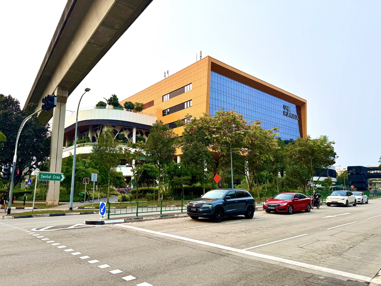
Punggol Drive is one of the streets tying together Punggol’s rail infrastructure, community facilities and daily residential journeys. Our new October 2026 photographs show cars stopped at a road junction beneath elevated LRT tracks, with One Punggol in the background. The photographs are ordinary street scenes, which is precisely why they matter: a family’s journey to the library, community club or nearby activities depends on the safe meeting of pedestrians, buses, cars, cyclists and rail passengers. The most useful question is not ‘Is this junction photogenic?’ but ‘How do we read the place well enough to travel responsibly?’
One Punggol is at 1 Punggol Drive, Singapore 828629, and its integrated hub includes a community club, regional library, hawker centre and other services. The elevated rail corridor is part of the wider Punggol LRT network, which LTA says began operations in 2005. The images document a road and overhead train infrastructure but do not establish a live LRT service frequency, legal stopping location or walking time to any specific entrance. For those, rely on current wayfinding and traffic signs.

Punggol Drive and One Punggol: quick orientation
- Place: Punggol Drive near the One Punggol integrated community hub.
- Hub address: 1 Punggol Drive, Singapore 828629, from the People’s Association.
- Visible landmarks: elevated Punggol LRT structure, a street junction, vehicles and One Punggol in the background.
- Transport context: Punggol LRT is a driverless local rail system connected to Punggol MRT on the North East Line.
- For pedestrians: follow present designated crossings and signals; a photograph is not a crossing map.
- For drivers: read current road markings, traffic signals and permitted stopping signs rather than assume a kerb can be used for pickup.
- For riders: distinguish marked cycling facilities from pedestrian areas and follow LTA’s current active-mobility rules.
- For family visits: share the full hub address, choose an appropriate entrance and leave time for safe crossings and wayfinding.
The principal public references are the People’s Association’s One Punggol contact page, One Punggol project overview, LTA’s Punggol LRT description, active-mobility rules and OneMotoring road-sign explanations. For the hub’s internal amenities, use the separate One Punggol facilities guide. Here we stay outside on the public street and explain the journey.
Why a street corner deserves its own local guide
People usually remember a destination, not the junction that gets them there. Yet a street junction decides where a family waits, how a bus crosses traffic, which approach a cyclist chooses and whether a young child can reach the correct sidewalk without improvising. Our October photographs place all these questions inside a recognisable Punggol scene: roads below, LRT above and a major community building nearby.
The guide is not a literal traffic engineering plan of that one intersection. We lack a certified geometry diagram, measured pedestrian counts and live signal timings. Its value is to help readers ask the correct questions from actual street-level evidence, then use current signs for decisions. That distinction makes a neighbourhood photograph a useful learning object rather than a decorative header.
What is visible, what is inferred and what remains unknown
The image metadata describes cars stopped at a Punggol Drive traffic junction beneath elevated LRT tracks, with One Punggol in the background. That is the observable scene. We might infer that the junction manages several traffic movements, because road intersections commonly do. But the photograph alone does not prove which lights are red, whether a right turn is permitted at that moment or how long the signal cycle lasts.
Do not label the street ‘always congested’ from one photo. Nor can we conclude that a person pictured on a nearby footpath is walking to a particular building. Local imagery becomes trustworthy when its captions stay descriptive and operational claims come from the correct authority. Students can use this same discipline when reading scientific diagrams and news photographs.
Understanding the building behind the road
The People’s Association describes One Punggol as an integrated lifestyle hub with multiple co-located services. Instead of placing every service in a separate building, the development brings civic and community functions into one destination. That makes the surrounding road network important. Visitors may be arriving for different reasons, at different times and with different mobility needs.
A parent heading to the library may follow the same public approach as somebody visiting an appointment, a community class or the hawker centre. But the appropriate entrance, floor and operating hours differ. The hub address identifies the site; it doesn’t settle the destination inside. Always specify both the building and the intended facility when arranging a family visit.
The elevated LRT as a visual landmark
An elevated rail viaduct is easy to spot and can help a newcomer recognise the part of town they are in. LTA’s description says the Punggol LRT connects residential neighbourhoods to Punggol MRT on the North East Line. The system began operations in 2005 and now serves 14 stations across two loops. Those are useful network facts, not conclusions derived from the road photo.
However, the structure overhead should not be treated as a pedestrian route. Seeing where the tracks go cannot tell you where the nearest safe crossing or station entrance lies. Road and station wayfinding remain separate. A family should follow ground signs rather than walk beneath a viaduct expecting its line to lead directly to the place they want.
Why rail above and vehicles below can coexist
Elevated railways separate train movement from ordinary street traffic at the points where the structures cross. This reduces certain kinds of direct conflict between rail vehicles and road users, while creating a substantial physical structure within the streetscape. Supporting columns, viaduct height and surrounding land use all shape the feeling of the road below.
The photograph is useful for discussing vertical land use: more than one transport function can occupy a similar footprint at different levels. But it does not reveal the engineering specifications, structural loading or maintenance standards of the viaduct. Those require technical sources. The visual lesson is about layers in a compact urban environment, not a homemade structural assessment.
How to identify the proper pedestrian crossing
A person heading toward One Punggol should look for the present designated pedestrian crossing and signal rather than aim directly at the visible yellow facade. A destination can be only a short distance away in a straight line while the legal route takes a little longer. That additional travel distance is not a design flaw by default; it may keep pedestrians separated from turning traffic.
If the intersection layout has changed since the photograph, current signs and barriers take precedence. Use the marked facility intended for pedestrians, watch for crossing signals and avoid entering the carriageway between queued vehicles. Parents should model patient crossing decisions for children who may otherwise learn to follow the fastest-looking path.
Traffic signals do not explain themselves through a still image
A stopped car in a photograph might be waiting for a red signal, another vehicle, a pedestrian or a turning opportunity. Without the relevant signal and time sequence, assigning a specific reason is speculation. Signals control potentially conflicting movements, but the precise phase sequence is local and can be changed by the authority.
A student interested in how traffic works could learn about the general principle of separating conflicting movements without claiming to know this junction’s timing. A still photograph does not constitute a traffic survey. If someone wants actual signal details for a research project, a properly authorised observational method or official information is required.
Why children may misread a stopped vehicle
A young child may assume a stationary car is safe to pass in front of. That assumption is dangerous. A driver could be waiting for a turn or preparing to move when a signal changes. Families should teach children to use marked crossings and to keep watching the road environment rather than rely on the speed of a single vehicle.
At a crossing, the appropriate pedestrian indication and full situation matter. Do not tell a child to cross merely because ‘the cars have stopped’. The stopping could be temporary and unrelated to the child’s path. A responsible adult demonstrates waiting, looking and crossing within the rules. Street confidence comes from stable habits, not improvised guesses.
A road junction is not a pickup bay
A driver seeing cars stopped at the junction might think there is somewhere convenient to wait nearby. The photograph cannot establish a permitted pickup or parking zone. OneMotoring explains that road signs and markings distinguish prohibited stopping, prohibited parking and limited immediate pickup or drop-off situations. A place used by one car is not necessarily legal for another.
If collecting a family member at One Punggol, confirm the current facility’s recognised drop-off or parking arrangements and follow actual road signs. Don’t block an intersection, crossing, bus movement or emergency access to shave a minute off the trip. A short walk from a permitted pickup point is preferable to creating a hazard at a traffic junction.
Understanding yellow lines without inventing the junction layout
Singapore uses different road markings to control parking and stopping. OneMotoring distinguishes single yellow lines, double yellow lines and zigzag markings, among others. Their restrictions differ, so a driver must identify the actual marking and any attached time condition rather than remember a vague rule that ‘yellow means no parking’.
Our images are not a substitute for reading the markings under the car and the signage at the site. Do not zoom into a blurry corner of a photograph and declare a particular kerb legal. If the road environment has changed, the live marking controls. Teaching older learners this difference between a general rule and its local application is a useful part of transport literacy.
How an LRT bridge changes the experience of shade
A viaduct may cast shade on some parts of the ground during certain times of day, but this does not guarantee a cool, sheltered or weatherproof walking route. Shade shifts with the sun, and rain can blow through uncovered spaces. A broad overhead structure may still leave pedestrians exposed at crossings or building entrances.
For a family with a toddler, older person or somebody sensitive to heat, plan the journey using actual comfort and accessible route information, not the expectation that ‘under the LRT’ equals shelter all the way. Weather and heat are practical variables. Keep water and rain protection appropriate to the trip, and be willing to shorten or change an outing.
Using the junction with a stroller
A stroller makes step-free continuity especially important. A pavement may look wide in a photograph but connect to a kerb, narrow corner or temporary barrier outside the frame. Before setting out, consider current crossings, ramp availability, lift access and the distance to the correct facility entrance. Avoid pushing a stroller across an unmarked carriageway simply because the opposite footpath looks close.
Where a route is uncertain, follow current accessible wayfinding or ask an authorised facility employee. The intended person and equipment matter: a parent with a stroller and a visitor using a wheelchair may have different practical needs. A route described as ‘nearby’ is not a reliable accessibility statement.
A safe family approach to One Punggol
Begin by deciding which part of One Punggol you are visiting. A library appointment, hawker meal or community-club class may use different floors and timings. Then choose the appropriate public route and identify a clear meeting point that does not obstruct pedestrian traffic. The goal is to move smoothly from transport to the actual facility without last-minute searching at a road junction.
The hub’s yellow facade, photographed separately in our October collection, can help readers recognise the destination, but colour alone does not tell them which entrance is appropriate. Use the People’s Association’s building information and current ground signs. A child’s school activity or scheduled programme may require a specific meeting arrangement provided by the organiser.
What the bright One Punggol facade contributes to wayfinding
Buildings sometimes use distinctive colours or forms to make them recognisable in a complex urban setting. One Punggol’s yellow entrance features are visible in the photo collection. These visual cues can help someone confirm they are near the intended site, particularly when the surrounding elevated rail and roads are visually busy.
But a colour cue should supplement, not replace, the formal address and signs. Other parts of the building may not share the same appearance, and lighting or camera settings can change a photograph’s colours. The useful instruction is ‘One Punggol, 1 Punggol Drive, follow the signed entrance’, not ‘look for anything yellow and walk through it’.
Punggol Drive and Sam Kee are not the same place as Punggol MRT
Sam Kee LRT serves the area around One Punggol, while Punggol MRT is the North East Line interchange at the town centre. They are part of the connected transport network but not identical stops. A passenger should check the intended rail station, route and final walking direction rather than assume that any overhead train seen near One Punggol is directly above Punggol MRT.
If a family is meeting at the hub, give the building address and relevant rail stop. A person new to the area should be able to search the route without guessing whether ‘near Punggol station’ refers to the main MRT or a local LRT point. For current services, rely on LTA and SBS Transit’s published information.
Why walking times in neighbourhood guides are estimates
Walking time depends on more than distance. Traffic signals, the correct entrance, weather, walking speed, stairs, lifts and children all matter. A two-dimensional map may offer a useful estimate but cannot guarantee the same duration for a caregiver with a stroller and an adult walking freely. Avoid writing an exact minutes-to-reach claim unless the route, origin and conditions are clearly defined.
For your own family, make a gentle practice trip and record how long the journey takes under ordinary conditions. Add a sensible buffer when an appointment starts at a fixed time. There is no need to rush a person through a signal because a website suggested the walk should have been shorter.
How bus users experience the same intersection differently
A bus passenger may alight on one side of the road and need a designated crossing before reaching One Punggol. Another traveller might arrive at a stop on the other side, making the final walk different even when the bus service number sounds similar. Stop codes and direction matter. A map pin for the building cannot determine the correct bus stop in every journey.
Use current LTA or operator journey information to identify the stop and direction first. Then inspect the walking route to the correct entrance. Children can learn to distinguish ‘nearby’ from ‘same side of the road’. This is a basic but important safety insight in a town where public transport, large buildings and road junctions meet.
Why a cyclist cannot simply use every pavement
LTA distinguishes pedestrian-only paths, cycling paths and other public routes, with rules that apply differently to bicycles and active mobility devices. A pavement beside Punggol Drive should not be assumed to permit every type of device just because a cyclist is occasionally visible nearby. The present markings and official categories decide legal use.
Cyclists should approach intersections carefully, follow the correct crossing type and give way according to the rules. Pedestrians should use the designated part of a split path when available. An ordinary street scene becomes safer when people recognise that the same broad corridor may contain distinct movement spaces.
What riders should do near busy crossings
LTA’s active-mobility code tells riders to slow around intersections and bus stops, give way to pedestrians and dismount where signs require it. These rules matter particularly when a child on a scooter, an adult on a bicycle and pedestrians are all approaching a turning point. Maintaining a straight path at speed is not the only consideration; awareness of vulnerable users is essential.
A family riding together should plan where it is safe to pause before consulting a map. Do not stop on a cycling lane or in the pedestrian movement path to take a photograph of the viaduct. If a route feels crowded, walking a device through an appropriate area may be sensible even where riding is technically allowed.
Phones, headphones and the crossing decision
A phone is useful for finding One Punggol, but it can distract a pedestrian at exactly the moment they should be watching vehicles and signals. Before crossing, stop using the screen, look up and attend to the live environment. Avoid listening to audio so loudly that important cues are missed. Drivers and riders have similar responsibilities not to use devices unsafely.
A parent can model checking directions while standing at an appropriate side area, then putting the device away before moving. The child learns that route planning and road crossing are two separate activities. The most effective safety lesson is often an adult behaving consistently, not giving a long speech.
Waiting at a junction with a grandparent
A person with limited mobility may require a comfortable amount of crossing time, predictable kerbs and access to somewhere to rest. Do not choose a route only because the adult who planned it can walk quickly. Ask the visitor how they would prefer to approach the hub and whether a particular crossing or lift arrangement matters.
Never urge somebody to hurry into an unsafe crossing to preserve a rigid plan. If an accessible route is unclear or temporarily blocked, look for the official alternative or seek assistance from the venue. Planning for the person’s actual needs makes a community destination more welcoming than a claim that ‘everybody can walk there easily’.
The difference between ‘traffic’ and ‘congestion’
A photograph showing several vehicles at a junction is not proof that traffic is abnormally congested. Signals naturally stop vehicles at intervals. Congestion is better evaluated through measurements of delay, queue length over time or reduced movement relative to ordinary capacity. One static image cannot distinguish these conditions reliably.
A secondary student could observe the difference between a queue generated by a normal red light and a persistent queue lasting through multiple cycles, using a lawful, safe method. That is a legitimate data-literacy question, but it requires more than a single photo. Avoid labelling a neighbourhood road permanently problematic from a dramatic-looking frame.
A hypothetical traffic-cycle Mathematics example
Suppose a made-up junction has a 90-second signal cycle, of which one approach receives 30 seconds of green time. The green share is 30/90, or one third. This illustrates proportional reasoning; it is not a measured timing at the photographed Punggol Drive junction. Real signals can have different phases and adaptive behaviour.
An older student can investigate what happens when the time allocation changes while traffic demand stays constant. However, mathematical models should not be mistaken for recommendations to alter the actual intersection. Road engineering includes safety, pedestrian timings, turning movements and coordination with other junctions. Calculating a ratio is only the beginning of understanding.
Why a zebra crossing and signalised crossing are different
Singapore uses several types of pedestrian crossing, and drivers and pedestrians have specific obligations at each. Do not use the word ‘zebra crossing’ for every marked pedestrian area or assume a photograph of white road stripes establishes the complete crossing type. The traffic signs and physical layout at the site are decisive.
For teaching children, name the actual crossing you encounter, point out its signs and practise the correct behaviour with supervision. A child who can recognise a zebra crossing in a worksheet may still need help using a signalised junction during a busy weekday. Street learning requires context and consistent practice.
An after-school journey is a different trip from a weekend walk
A route to a community programme after school may involve different time pressure, weather and traffic from a leisurely weekend visit. Children may be tired, carrying bags or thinking about the next activity. Adults should leave enough time for the crossing and entry process rather than try to recover a delay by moving quickly around cars.
If a child attends an activity at One Punggol, the organiser’s current pickup instructions remain essential. An adult may be able to recognise the building from the photograph while still not knowing the correct floor or designated collection point. School and programme safety rules should not be inferred from the external street view.
The rainy-day version of the journey
A road junction in rain can be less comfortable for pedestrians. Umbrellas reduce peripheral visibility, surfaces become wet and people may crowd under small sheltered areas. Choose a controlled pace, keep younger children near and do not step into a carriageway to avoid getting wet. An inconvenience is not worth a hazardous shortcut.
Some sections beneath the viaduct may be shaded or sheltered, but the photographs do not prove a continuous protected route to the hub. Prepare for the actual weather and consider an alternative time for a nonessential outing if conditions are poor. Lightning requires appropriate safety decisions beyond simply standing under a large structure.
The hot-afternoon version
A bright day can make road crossings and open footpaths uncomfortable, especially for children or older visitors. The elevated track may create patches of shade, but ambient heat and humidity remain relevant. Allow for water, rest and a sensible walking pace without promising that an overhead viaduct makes the entire route cool.
If a family has to reach a timed appointment, begin earlier rather than expecting someone to hurry through heat. People experience temperature and exertion differently. A practical plan accommodates that variation; it doesn’t use a shortest-walk estimate as a target everyone must meet.
Why a building entrance needs a separate wayfinding check
The address ‘1 Punggol Drive’ identifies the whole integrated hub. Its services occupy different floors and may have distinct opening hours, access paths or event arrangements. A person arriving for the regional library has different information needs from somebody going to a community-club court. An exterior photo cannot show the correct internal destination.
After reaching the site safely, look for the current building directory and follow the correct sign. Do not assume every service’s access is through the entrance most prominent in one picture. Our One Punggol’s High Roof article focuses on the interior-adjacent public architecture; this street guide stops at the safe approach.
One Punggol and the Punggol Regional Sport Centre are different destinations
A new Sport Singapore regional sports complex also stands in this broader area, but it is a separate development at 11 Sentul Crescent. Some travellers may see the buildings in one neighbourhood and confuse the operators or facilities. One Punggol’s community club and the regional sports centre have different booking systems, access arrangements and opening statuses.
Before committing to a class or sports session, check the actual venue named in the reservation. The two-centre comparison handles that issue. A photograph of the road leading toward a building should not be treated as a booking confirmation for a different nearby facility.
What a driver should do if the planned entrance is missed
Missing a turn can be frustrating, especially with passengers waiting. Do not make an illegal U-turn, reverse into traffic or stop abruptly to consult a phone. Continue safely, follow permitted road movements and re-plan through lawful routes. Current traffic directions and signs outrank a navigation app that appears to suggest an impossible manoeuvre.
A parent can also choose a permitted drop-off point rather than insist on reaching the front of a particular doorway. There may be access routes better suited to the group than a kerb near a junction. The final few metres should be planned as carefully as the drive from home.
The importance of road markings to delivery vehicles
One Punggol brings together multiple services, and a large community building relies on deliveries, maintenance and other operational trips. The road photograph cannot show the designated goods entrance or permitted loading arrangements. Private delivery drivers should use current access instructions from the premises, not guess a shortcut from the way the facade appears.
Pedestrians should likewise avoid walking into service areas to cut distance. A mixed-use hub works when public arrival routes and operational movements remain appropriately separated. That principle is general; the exact One Punggol circulation plan must be taken from the responsible operator, not reverse-engineered from street images.
A street-level photograph cannot prove universal accessibility
A wide view showing a clean pavement and modern building may create an impression of easy access. Yet accessibility depends on individual kerbs, ramps, lifts, gradients, surfaces and current obstructions. Those details may not be visible from the camera’s position. A specific visitor should not be promised a fully step-free journey solely because the road photo looks modern.
When accessibility matters, check the route and facility with current official information and seek assistance where appropriate. Different visitors may require different solutions. A respectful guide describes what can be verified and leaves detailed access decisions to evidence and the person’s own preferences.
A simple observation exercise for Primary 1 and Primary 2
Ask a young child to name what is above, below and behind in the photograph. They may say ‘train track’, ‘road’ and ‘yellow building’. Correct gently where needed, distinguishing tracks from an actual train if no train is visible. This develops location vocabulary using a familiar neighbourhood rather than abstract shapes.
Then talk about why pedestrians use the crossing instead of walking across the road anywhere. Keep the explanation concrete and age-appropriate. The aim is not a test of transport knowledge but an understanding that different users have different places to move. Adult supervision remains essential during actual crossings.
A Primary 3 to Primary 4 map-reading activity
An older primary pupil can draw a simple labelled diagram of the photographed scene: road, elevated LRT track, footpath and destination building. The diagram may not be geographically exact; label it as a sketch rather than a survey plan. Ask which additional information would be required to show a safe route: crossing location, signs and real entrance.
Compare the sketch with current official mapping. Children may notice that the shortest drawn line is not a safe walking path. That is an excellent lesson in modelling. Maps simplify the world, and the quality of a route depends on constraints that a line alone does not show.
A Primary 5 Mathematics lesson about routes
Imagine a hypothetical walking plan with two segments of 120 metres and 180 metres, separated by a signalised crossing. The total path length is 300 metres, but the walking time depends on the crossing delay and walking pace. A child who divides distance by speed without including waiting time may produce an optimistic estimate.
Use invented values openly. Suppose a person walks at 1 metre per second and waits 40 seconds at the light: the illustrative journey takes 340 seconds, or 5 minutes 40 seconds. Those figures are not measured at Punggol Drive. This example shows how real-world problems require correct models, not only correct arithmetic.
A secondary Geography inquiry about compact urban design
Students can identify three visible layers: elevated public transit, road movement and a major community destination. Then ask what advantages and conflicts arise when these functions share limited land. Rail can connect neighbourhoods; roads provide access; community hubs gather services. At the same time, crossings, noise, space and accessibility have to be managed.
A thoughtful inquiry distinguishes the photograph’s observations from planning documents. To claim why a viaduct was placed where it is, a student needs official design information. To assess the experience of people with mobility needs, more than a visual estimate is required. Stating limits is part of sound urban research.
A Design & Technology discussion about wayfinding
Why do large buildings use distinctive visual elements, maps and signs? Because a visitor must convert an address into an actual route. One Punggol’s yellow facade provides a useful recognisable feature, while transport and floor directories supply more precise instructions. Different information layers serve different purposes.
A student could create a hypothetical wayfinding sign that distinguishes ‘library’, ‘community club’ and ‘hawker centre’ without implying it is official. Test it with classmates using a schematic route, not by altering real signage. The task demonstrates why design should be understandable to people who are unfamiliar with the building.
A Social Studies question about who owns the street experience
Roads are not only for drivers. They are part of the movement system used by children, commuters, delivery workers and residents with different needs. A signal phase that seems slow to one person may provide time for another to cross safely. Shared infrastructure involves trade-offs that cannot be evaluated solely from the perspective of the fastest traveller.
Students can compare different users’ needs fairly rather than advocate an arbitrary solution from a photograph. A parent with a stroller may value ramps; a cyclist may value a well-marked crossing; a driver may need clear lane instructions. The strongest conclusion is often a more precise question about evidence and design.
A media-literacy exercise using two camera angles
Compare the image of cars at the junction with the wider view of the road beneath the elevated LRT. One composition highlights stopped vehicles; the other places the road in a larger architectural context. The framing changes the story a reader might tell. Neither image is inherently deceptive, but both are partial.
Ask a student to write a caption for each without using words such as ‘gridlock’ or ‘dangerous’ unless evidence supports those claims. Then ask what information is missing: duration, actual traffic volumes, signal phase, crossing accessibility and time of day. This teaches careful interpretation of current media images.
Why public photography should not identify passers-by
The new street photographs may include drivers, pedestrians or passengers in the background. There is no need to identify individuals, infer where they live or speculate about their reason for travelling. Broad streetscape photography can explain a place without turning ordinary residents into characters in an article.
If creating your own photograph, stand only where it is lawful and safe. Do not obstruct footpaths, stand in the carriageway or photograph into private vehicles for a better shot. Focus on the structures and public signs that actually help readers understand the route. Ethical framing is part of accurate local documentation.
How to choose a safe meeting point
If two family members are meeting at One Punggol, agree on a clearly identifiable public location within the allowed pedestrian environment rather than the middle of a crossing or turning area. Include the building’s full address and the specific facility where necessary. A person waiting should not be forced to block other pedestrians.
Avoid using the photo’s camera position as an exact meeting instruction. We cannot verify the photographer’s precise legal standing point or whether conditions will be identical later. Choose current signed public areas and ask venue staff for help if meeting arrangements are unclear.
Temporary barriers can change a familiar walk
Construction, maintenance or events can redirect pedestrians. An article written in October cannot guarantee that a particular pavement remains continuously available next year. If you see a barrier, follow the posted diversion instead of climbing it or walking through a vehicle lane. A photo from an earlier day is not permission to ignore a current closure.
Parents can prepare children for this uncertainty: a blocked path does not require improvising an unsafe shortcut. Stop, check the current directional sign and ask an authorised person if necessary. Flexible route planning is a practical skill in a growing town.
Why an overhead rail landmark is not a service timetable
The Punggol LRT structure is visually prominent and may make people think constantly about trains. But the mere existence of an elevated line says nothing about when the next train will arrive, whether a particular station is served by a given service pattern or whether there is an operational alert. LTA and the operator provide those details.
Students can learn to separate fixed infrastructure from variable service. A bridge or rail line is part of the physical network; a timetable describes its use over time. That difference mirrors other systems: a school building does not prove today’s class schedule, and a swimming complex exterior does not prove that a pool is open.
An evening family journey
After dark, visibility changes and crossing decisions require full attention. Check signals, keep children close and avoid placing yourself where a driver may not expect a pedestrian. Do not photograph a road at night from the carriageway. A glowing building or elevated line may look attractive, but the legal public viewing point matters more than the image.
If a group is tired after a community event, it may be sensible to pause at an appropriate indoor or sheltered area before returning to transit. Keep the next leg clear in your messages. A family should never rely on vague instructions such as ‘walk towards the train until you see a road’ when safe signed routes are available.
The transport network as part of a child’s independence
Children eventually learn to move from home to school, community facilities and local transit with increasing responsibility. The Punggol Drive scene is a useful starting point because it combines several route elements: public rail, road crossings and a major destination. A child can learn to recognise them while still travelling with a responsible adult.
Progress toward independent travel should be based on demonstrated judgement and a family safety plan. The child needs to know how to react to a blocked route, uncertainty or a late connection. Recognition of a building from a photo is one skill, not a complete assessment of travel readiness.
A practical final checklist for Punggol Drive
Before leaving, confirm whether you are visiting the library, community club or another One Punggol facility. Use 1 Punggol Drive as the hub address, then identify the current pedestrian approach and any specific entrance instructions. Allow extra time for children, mobility needs and traffic signals. Take relevant weather precautions.
At the junction, obey present traffic and pedestrian signs rather than copying a route from a photograph. Drivers should use legal stopping and parking arrangements; riders should follow the correct path type. After reaching the building, read the current directory. The photographs should make the scene familiar, not replace the real information you need.
What the photo set contributes to the town’s memory
Punggol changes quickly enough that ordinary street scenes can become valuable records. A photograph of cars beneath an LRT viaduct, with a community hub behind them, captures a particular arrangement of the town in 2026. Later readers may compare it with changes to signage, transport services or nearby development.
That historical value does not make the image a perpetual guide to current traffic law. Date it clearly, state what was visible and connect any time-sensitive operational claim to an official source. The result is a local record that can remain useful without misleading future travellers.


Frequently asked questions about Punggol Drive, the LRT and One Punggol
Where is One Punggol?
The People’s Association lists 1 Punggol Drive, Singapore 828629.
Does the photo show Punggol Drive?
Yes. The October 2026 media metadata identifies the Punggol Drive junction and elevated LRT structure with One Punggol behind.
What is the train structure overhead?
It is part of the Punggol LRT’s elevated rail network. LTA provides the authoritative system description.
Is One Punggol the same as the Punggol Regional Sport Centre?
No. They are distinct destinations with different facilities and operators.
Which station should I use for One Punggol?
Sam Kee LRT serves the surrounding area. Use current route guidance for your particular origin and entrance.
Can I cross beneath the LRT anywhere?
No. Use current legal pedestrian crossings and follow signals and barriers. An overhead viaduct does not authorise street crossing.
Is every footpath under the tracks a cycling path?
No blanket conclusion is justified. Use the present path markings and LTA’s active-mobility rules.
Can I stop a car at the junction to drop off a family member?
Do not infer permission from the photograph. Check current signs, markings and the facility’s approved vehicle access.
Does the photograph prove congestion?
No. Vehicles stopped at a signal do not establish abnormal congestion or persistent delays.
Is the route fully sheltered?
The photos do not establish a continuous sheltered route. Check the real walking route and weather.
Is the area accessible for a wheelchair or stroller?
Accessibility depends on the exact path, ramps, kerbs and lifts. Confirm the present route and facility arrangements.
Can I use a photograph to measure how long the walk takes?
No. The image lacks a verified scale and ignores crossings, route geometry and walking pace.
What does the bright yellow building signify?
It is a visually distinctive architectural feature of One Punggol, helpful for recognition but not a substitute for official wayfinding.
How do I know the correct entrance?
Use the building directory, posted wayfinding and any directions from the service or event you are attending.
Should children learn to navigate the junction alone?
Travel independence should be assessed individually and practised appropriately; photos alone cannot establish readiness.
Can we photograph the road from anywhere?
No. Photograph only from lawful, safe places without blocking pathways or capturing unnecessary personal details.
What if a pavement is blocked?
Follow current diversion signs and do not enter restricted vehicle areas or cross unsafely.
Is this a live road-condition guide?
No. It is a dated October 2026 explanatory photo guide. Current traffic, route and service information belongs to official sources.
Which article explains all the facilities under One Punggol?
The separate One Punggol integrated hub guide covers the library, community club, hawker centre and other services.
What can students learn from the pictures?
They can study urban layers, evidence-based captioning, route modelling, pedestrian safety and the difference between visible infrastructure and current operations.
Sources and onward reading
- People’s Association — One Punggol Address.
- People’s Association — One Punggol Integrated Hub Overview.
- LTA — Sengkang–Punggol LRT.
- LTA — Rules and Code of Conduct for Active Mobility.
- OneMotoring — Driving Rules, Signs and Road Markings.
- One Punggol Guide — internal services and facilities.
- Under One Punggol’s High Roof — public space and architecture.
- Punggol Regional Sport Centre vs One Punggol.
- Understanding Punggol Transport.
- Complete Punggol Guide
Editorial and photo record, 23 October 2026: local images uploaded in October 2026 by eduKatePunggol show a Punggol Drive road junction, LRT viaduct and One Punggol’s exterior. All photo descriptions are limited to visible evidence. This is not a current traffic-flow survey, authorised pickup plan or guarantee of accessible routes; follow live public signs and official facility directions.


