
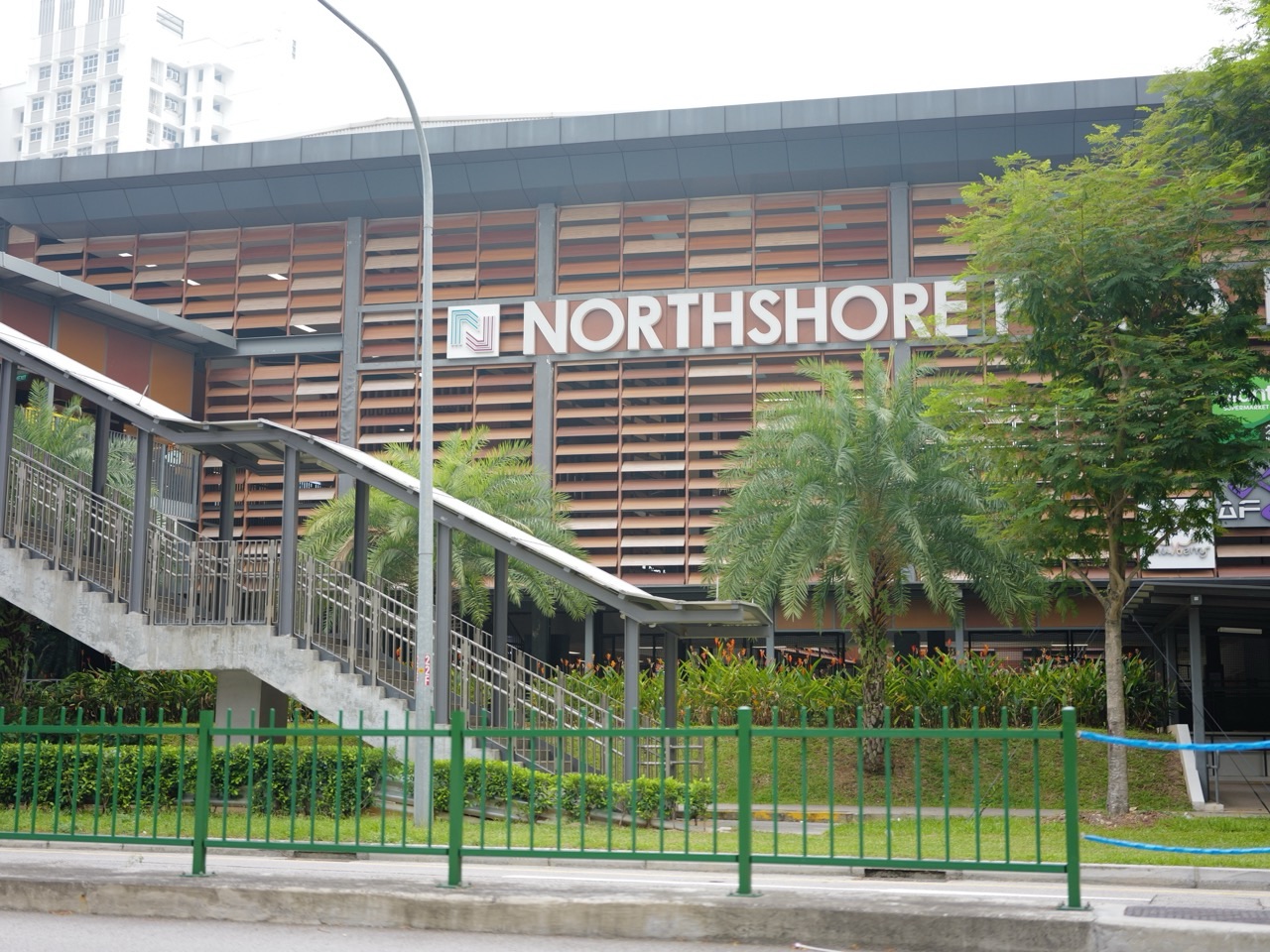
Why does Northshore Plaza I and II in Punggol connect Samudera LRT station, shops, surrounding HDB homes and the seafront through a two-level sheltered community spine, instead of simply putting a shopping centre in the middle of a road junction? A resident usually needs several ordinary destinations in one journey: groceries, a bus or LRT connection, a playground, a meal, and sometimes a waterfront walk. Northshore’s design deliberately links those journeys through one continuous pedestrian-oriented route.
HDB’s Our Town, Punggol: Town Design Guide, updated in 2024, identifies this two-level community spine as the main connector from Samudera LRT through Northshore Plaza I and II to housing precincts and the coastal promenade. Its 2022 Design Awards described the spine as connecting four HDB residential projects with approximately 3,100 flats, shops, landscape decks and the seafront. This is a documented planning mechanism rather than a guess that two malls just happen to stand near one another. The idea is to make a neighbourhood centre part of the walking network, not merely a destination reached by vehicle.
- Where: Northshore Plaza I and II in Punggol Northshore, serving nearby HDB estates and the Samudera LRT area.
- Main feature: a two-level sheltered community spine extending towards the coastal promenade.
- Purpose: connect everyday shopping, housing, public transport, playgrounds, community spaces and waterfront recreation.
- Original milestone: Northshore Plaza began operations in October 2021 and officially opened in July 2022.
- Design context: HDB’s first seafront new-generation neighbourhood centre within the smart, biophilic Northshore district.
- Important distinction: a connected walkway is not a guarantee that every metre is sheltered during wind-driven rain or accessible through every shop after closing.
- Current visitor need: check the exact entrance, LRT direction and shop location rather than assume Plaza I and II share one identical doorway.
Why the word spine fits the layout
A spine connects parts of a body. In urban planning, a community spine is a primary walking connection that links different destinations. It is a network concept rather than one decorative corridor.
At Northshore, HDB describes a two-level route stretching between the Samudera LRT side, the plazas, housing precincts and the seafront. People can use it on an ordinary journey without necessarily intending to browse every shop.
The key planning benefit is continuity. Separate attractive facilities become more useful when residents can travel among them through routes that are legible, appropriately sheltered and connected to the actual neighbourhood.
Why Northshore has two plaza components
Northshore Plaza I and II form a connected commercial centre serving the wider Northshore district. The two names help identify different sections of a broader development rather than one undifferentiated retail floor.
HDB’s town design guide labels both plazas on the district plan and places the community spine through them. A family asking to meet at “Northshore Plaza” may need to specify which section and entrance.
The design can function as one connected public destination while still having distinct addresses, tenant spaces and circulation. Integration does not remove the usefulness of precise place names.
Why proximity alone is not enough
Two buildings may be only a short straight-line distance apart yet require a long route if there is no suitable connection. Roads, level changes and entrances influence how close they feel in practice.
HDB’s Northshore spine deliberately provides a route among the station, plazas and nearby blocks. That changes the geometry of everyday travel rather than merely placing more amenities in one district.
For students, the distinction is between map distance and accessible travel effort. A pedestrian route must actually connect the relevant entrances to create the intended convenience.
Why the link uses two levels
HDB identifies a two-level sheltered pedestrian spine rather than a single ground-level path. This helps link development components and circulation levels that have different positions and functions.
A multi-level connection needs suitable transitions between levels, including paths and vertical access under its approved design. The section diagram is especially helpful for understanding this arrangement.
A two-level system is not inherently better in every town. It works here because the development’s actual buildings, public spaces and seafront sit within a specific urban arrangement.
Why Samudera LRT is the starting point
Samudera is one of the Punggol West Loop stations serving the Northshore area. People arriving by local rail may want to continue to homes, shops or the coast.
A route connected with the LRT reduces the need for some visitors to navigate multiple disconnected roads or car-park entrances before finding the main amenities.
The station remains a transport service with its own signs and operating conditions. A linked neighbourhood centre does not eliminate waiting times, loop-direction decisions or the need to use current travel information.
Why the waterfront is the other destination
Northshore faces the northern coast, and HDB’s design seeks to connect housing and neighbourhood amenities to the coastal promenade. The route therefore has recreational as well as practical value.
A resident can use the same broader connection for groceries on one day and a seafront stroll on another. It helps residents experience the waterfront as part of local life rather than an isolated attraction.
Actual access may vary with weather, works and the route chosen. The presence of a coastal destination does not guarantee that all connected public spaces are open around the clock.
Why shops line the walking route
HDB’s design guide says the community spine is lined with retail, dining and community spaces. These activities give residents practical reasons to use the link and pause along it.
A walkway beside active shops can feel different from a long enclosed service corridor. It can combine movement with ordinary errands and social activity.
But businesses maintain their own operating hours and rules. The path’s planning function should not be confused with a claim that every shop is always open when the LRT is operating.
Why a family can combine errands
A household may need food, groceries and a walk to transport during one outing. Locating these activities along a connected route can reduce unnecessary repeated travel between separate buildings.
That benefit depends on actual origins, destinations and opening conditions. A shop a family wants may not operate there, or its particular entrance may not be on the preferred route.
The useful conclusion is not that all trips become shorter. It is that the planning creates opportunities to combine legitimate activities efficiently within a compact neighbourhood.
Why a neighbourhood centre is not just a mall
HDB designs neighbourhood centres to provide everyday amenities near homes. New-generation centres also include spaces for gathering, play and community activities.
Northshore Plaza incorporates a green lawn, community pods, sheltered gathering space and themed playgrounds in addition to shopping and food outlets.
These features make the centre an area for neighbourhood life, not only transactions. Residents can gain value from a public route or green space even when they do not buy anything.
Why the HDB housing projects matter
HDB’s 2022 Design Awards described approximately 3,100 flats across Northshore Residences I and II and Waterfront I and II, linked with Northshore Plaza.
The size gives context for the pedestrian connection: it serves a substantial population as well as visitors arriving by public transport. The exact number is an award-era project figure, not a count of residents currently living there.
A shared spine is useful only when it reaches the homes and facilities around it. The design connects the residential environment with the neighbourhood centre instead of treating each block as an isolated island.
Why shelter matters in Singapore
An ordinary shopping journey can be uncomfortable during heavy sunshine or rain. Sheltered routes reduce some exposure, especially for caregivers, children and older people.
HDB deliberately describes Northshore’s community spine as sheltered. This can make trips between buildings more practical during ordinary weather conditions.
But a roofed section does not guarantee protection from lightning or wind-driven rain. A sensible resident still follows weather alerts and uses appropriate cover during severe conditions.
Why shelter is not the same as indoor air-conditioning
A sheltered community spine can be open to the surrounding environment rather than sealed like a conventional air-conditioned shopping gallery.
This changes how sunlight, air and humidity influence comfort. Northshore Plaza’s design deliberately takes advantage of breezes and open-concept circulation.
Residents should not assume the entire route has the same temperature or ventilation as an indoor supermarket. The environmental design has multiple zones and different operating conditions.
Why accessibility must be considered across the whole route
A person using a wheelchair may need suitable gradients, lifts, clear widths and entrances. A stroller also changes which paths are convenient.
A continuous line on a planning map is only part of accessibility. The actual route must also work at its level changes and entry points.
Visitors with specific needs should verify the current step-free path rather than rely on the assumption that every short connection is accessible in precisely the same way.
Why an ordinary crossing still matters
A public route may pass near car-park entrances, delivery zones or roads. The design’s convenience does not remove those interactions automatically.
Pedestrians must use authorised crossings and follow actual signals. The community spine is not permission to cut across a vehicle lane because the destination looks close.
For students, the important distinction is between a connected route and an unregulated shortcut. Safe circulation is part of the intended public service.
Why the connected route can aid older residents
Some older people benefit from nearer amenities, places to rest and predictable walking routes. Repeated trips become easier when unnecessary detours are reduced.
Community pods and seating create opportunities to pause, subject to their actual availability and intended use.
The design does not guarantee the same comfort for every individual. A person with particular mobility needs may still need to check distances, lifts and surface conditions before a journey.
Why children experience the route differently
A caregiver accompanying a child may need to supervise crossings, hold hands near vehicles and manage stops at play areas.
A route connecting housing, shops and playgrounds can offer a coherent outing without requiring several car journeys.
The playgrounds remain designated facilities with age and safety rules. The existence of a shared public route does not make every planted area or staircase suitable for unsupervised play.
Why a public plaza needs an activity plan
HDB describes communal areas and a sheltered plaza within Northshore Plaza’s wider design. Such spaces can support suitable neighbourhood events or informal gathering.
Without practical arrangements for use and maintenance, a public square may function only as a space people hurry through.
A community area still needs management. An empty plaza cannot automatically be reserved for a private event, and businesses should not occupy circulation paths without approval.
Why green spaces flank the connected route
HDB’s Town Design Guide identifies common greens and landscaped decks around Northshore’s residential projects. These connect with the community spine and waterfront promenade.
They provide visual relief and opportunities for residents to pause, play or enjoy planting close to home.
A planted deck is not automatically a public garden for unrestricted access or harvesting. Each space has intended functions and management rules that should be respected.
Why roof gardens complement the route
The Northshore residential blocks include landscaped decks and rooftop gardens under the wider biophilic approach. These spaces add greenery across several vertical levels.
The community spine helps connect ground and upper public spaces with surrounding amenities, subject to the actual site layout.
This is a layered public environment. But a visible green roof may be maintenance-only, so residents should check permitted access rather than assume every planted surface is a destination.
Why the seafront edge needs openings
HDB’s town design guide discourages continuous wall-like waterfront development and calls for appropriate openings and public connections.
A waterfront view has little community value if tall blocks and inaccessible sites prevent residents from reaching it. The spine helps organise physical access through developed land.
The guideline is a design principle, not a guarantee of unchanged sea views from every home. Public access and private views are different planning questions.
Why the two-level spine is a physical system
A pedestrian connection includes actual paths, railings, lighting, covered segments, signs and supporting structure.
Those elements must be maintained. A disconnected escalator or damaged walkway can influence the trip even while the broader masterplan remains unchanged.
Describing the spine as an ecosystem of movement is useful only when the physical facilities and operational responsibilities are recognised. A plan alone is not a maintained route.
Why a plan section reveals more than a map
An aerial map may show Northshore Plaza I and II beside the LRT and coast, but it cannot readily show how different circulation levels relate.
HDB’s Town Design Guide includes a section drawing tracing the community spine through the development towards the seafront.
Students can compare plan and section to understand vertical and horizontal connections. Neither image is a substitute for today’s wayfinding signage or a certified accessibility audit.
Why the community spine is not a commercial app
Northshore Plaza also has digital shopping and parking services. Those operate as software or operational platforms.
The community spine is different: it is a built pedestrian link between destinations. An app can provide information about a shop but cannot replace a walkway.
Distinguishing physical, digital and human services helps prevent vague descriptions in which every feature is simply called smart without explaining its actual job.
Why the design was recognised by HDB
HDB’s 2022 Design Award highlighted the integration of Northshore Residences, Waterfront I and II and the neighbourhood centre, including the two-storey connected walkway.
The recognition demonstrates that the planning and architecture were considered a notable design approach.
It does not guarantee that every resident never experiences a fault, a closed shop or an inconvenient route. Awards describe a project achievement; actual operation has to be evaluated separately.
Why open design and wind can support comfort
Northshore Plaza features an open-concept design and louvred elements intended to work with the seafront climate.
That can help bring natural airflow into selected public areas, while the relationship with shading affects comfort.
But a seafront location does not guarantee a breeze at every moment. The specific wind and thermal conditions change with weather and the built environment.
Why smart fans have a separate job
HDB reported using smart fans in Northshore Plaza to help manage comfort when environmental conditions require additional air movement.
Those fans perform a different role from the community spine’s walking connection. One concerns the experience of air, the other the physical route among destinations.
The system’s existence does not warrant inventing today’s sensor thresholds, fan settings or exact energy savings. A useful explanation identifies the documented purpose without claiming access to private operating data.
Why skylights matter in a retail connection
Northshore Plaza’s environmental design uses skylights to admit daylight into appropriate parts of the development.
Daylighting can reduce the need for some artificial lighting under suitable conditions but also requires careful control of heat and glare.
A bright photograph at midday does not establish actual annual electricity savings. The design mechanism is understood more accurately by connecting daylight, building geometry and operating conditions.
Why the promenade is another transport route
A coastal promenade can support walking and cycling where permitted. It is part of Punggol’s wider network of park connectors and waterfront amenities.
Linking Samudera LRT through the plazas to this route creates choices beyond shopping: a resident may use the same area as part of a recreational or commuting journey.
The actual path designation matters. A cyclist should follow current signs and dismount where required rather than assume every pedestrian link is suitable for riding.
Why two shopping centres can be one coherent neighbourhood destination
The names Plaza I and Plaza II identify different commercial components. The walking spine gives them a relationship within one wider development.
A connected arrangement can feel easier to navigate than separated retail blocks requiring multiple unrelated street crossings.
However, a connected destination does not make every shop or entrance interchangeable. People arranging a meeting should identify the correct plaza, level and entrance.
Why navigation needs more than the label Northshore
A visitor can confuse Northshore Plaza I and II or assume Samudera LRT is beside every shop.
The practical journey requires the particular store or meeting point, a suitable route and current operating information.
The existing Northshore Plaza I vs II guide explains exact addresses and meeting points. This article answers why a two-level shared route links the area in the first place.
Why shops can change without changing the urban design
A retailer may open, close or move while the public path remains part of the estate’s physical structure.
The long-term value of the spine comes from linking destinations, including residential areas, transport and the waterfront, not from one specific shop brand.
This is why a 2022 planning account can remain relevant years later even if a 2026 tenant directory is different. The design’s purpose and current commercial content are separate facts.
Why a shared walkway can create community
Residents who repeatedly use the same routes may encounter neighbours, notice community activities or stop to rest.
The route creates opportunities for casual interaction, especially when it includes seats, greenery and everyday amenities.
But architecture cannot guarantee friendships or a universally positive experience. Social outcomes depend on the people using the space and the management of its activities.
Why the route helps people without private cars
A shopping area linked with LRT and public walkways can be reachable by people who do not own or use a vehicle.
That may reduce the need for a special car trip to access everyday amenities, depending on where the household begins and what it needs.
This is a planning benefit of proximity to public transport, not a claim that parking is unavailable or that every possible journey is equally convenient.
Why delivery trucks still need separate access
Retailers must receive stock and dispose of appropriate waste. Public pedestrian links do not make these functions disappear.
The building design must accommodate servicing while keeping ordinary shoppers safe, following its actual approved arrangements.
A visitor should not use an unsigned service corridor as a shortcut. Distinguishing back-of-house operations from public routes helps the mixed-use environment function safely.
Why a sheltered spine is not flood protection
A covered walking route may shelter people from some rain and sun, but it is not the same as a flood barrier or reservoir gate.
The wider coastal district requires its own drainage and long-term environmental planning.
Describing the feature as sheltered should not lead to unsafe claims about crossing the area during severe storms or floods. Follow current public safety information.
Why the spine needs good lighting
Public circulation is used at different times of day, and artificial lighting helps people see routes and steps when natural light is low.
Northshore’s broader smart lighting and environmental design aim to provide appropriate lighting while using resources efficiently.
A well-lit walkway still requires ordinary care and compliance with posted directions. Lighting is part of the usable environment rather than a guarantee of safety in every circumstance.
Why a visible connection can encourage use
People are more likely to use a connection when they can understand where it leads and feel confident about the path.
The spine’s relationship with shops, dining and the coast gives it identifiable destinations, making it more than a hidden rear passage.
This illustrates the importance of wayfinding and lines of sight in public planning. A technically short route is less useful if ordinary visitors cannot recognise or access it.
Why the spine can be part of a school Geography lesson
Students can draw a simple line from Samudera LRT to Northshore Plaza I, Plaza II and the seafront.
They then identify different functions along the line: transport, commerce, common green and recreation.
The exercise teaches the difference between a network connection and isolated points on a map, and why a route’s purpose must be understood through the destinations it serves.
A fictional before-and-after comparison
Imagine three separate buildings with no sheltered connection. A resident must cross exposed roads between a station, shops and a park.
Now connect them with a planned pedestrian spine under appropriate conditions. The student lists possible reductions in detours and exposure while noting that real access still depends on the built route.
The comparison is a conceptual learning model, not measured journey times for Northshore Plaza.
A fictional journey-time example
Suppose a family walks six minutes from an LRT stop to a shop, then four minutes to the promenade, with an additional two-minute detour because of a closed passage.
The total walking effort is twelve minutes under these invented values. Remove the detour and the total becomes ten minutes.
The calculation illustrates the cost of an interrupted connection but does not establish actual walking time for any Northshore visit.
A fictional map-and-section exercise
Draw the commercial centre in plan view and mark its two plaza components. Then draw a vertical section showing two pedestrian levels and the housing precincts around them.
Ask which drawing best communicates location and which reveals the relationship between levels.
This helps students select suitable representations for urban design without assuming a paper section is an exact construction plan.
A fictional accessibility exercise
Give two travellers different needs: one can use stairs comfortably and another needs step-free access.
The class must identify what information is missing before choosing a route, such as the actual lift location and current operation.
The goal is not to rank people but to show that public design serves diverse users only when practical circulation is considered.
A fictional weather scenario
Two friends stand on a sheltered part of the link while wind-driven rain reaches an adjacent exposed section.
They discover that the word sheltered does not apply equally to all conditions and directions.
The correct action in severe weather is to seek appropriate safe shelter and follow official guidance, not treat the spine as a guaranteed storm refuge.
A fictional shared-space dispute
A group wants to place tables across a connecting walkway for an informal activity. Other residents need the route to reach transport and shops.
The class discusses why designated public circulation must remain usable and why organisers need the correct permission for any event setup.
This is civic learning: a public route serves many people and cannot simply become the exclusive property of whichever group arrives first.
A fictional tenant change
A popular shop closes at one plaza. Someone concludes that the community spine has lost its purpose.
The class identifies its other connections: the LRT, housing, community spaces and coastal promenade.
A changing tenant mix can affect reasons to visit, but the infrastructure’s broader connectivity continues to matter. The discussion separates commercial activity from public-space value.
Why the two-level community spine is distinct from Oasis Terraces
Oasis Terraces combines a polyclinic, childcare and shops in one neighbourhood centre, with its own planning history.
Northshore Plaza’s special feature is the two-level sheltered spine linking the LRT, two commercial components, large residential precincts and the seafront.
The Oasis Terraces integrated healthcare guide covers a different co-location mechanism, so the two developments should not be treated as interchangeable.
Why this story is not simply about Northshore sea breezes
HDB’s Northshore design includes staggered residential heights, greenery and environmental simulation for ventilation and shade.
Those features are important but answer a different question from how the pedestrian network connects everyday destinations.
The earlier Northshore wind-and-shade explanation focuses on environmental comfort. This article focuses on the route linking homes, services, transport and the waterfront.
Teaching Guide: draw a community spine that actually connects
Learning goal: explain how a multi-level public route can link a neighbourhood’s separate functions and why it must remain safe and accessible.
Activity one: place Samudera LRT, two plazas, housing precincts and the coast on a fictional map. Activity two: draw a connected walking route and distinguish it from an unapproved vehicle shortcut.
Activity three: add different levels and accessibility needs. Activity four: locate seating, shops, public greens and a playground along the line. Activity five: introduce a shop closure or temporary walkway disruption and ask what alternatives are needed.
Transfer test: compare a different development with separated shopping and transport and explain which features of Northshore’s approach might or might not suit that location.
Frequently asked questions
What is Northshore’s community spine? HDB’s two-level sheltered pedestrian connection running from Samudera LRT through Northshore Plaza I and II towards housing and the seafront.
Is it the same as a single shopping corridor? No. It connects several buildings, public spaces and destination types.
What is its purpose? To make suitable walking journeys between transport, shopping, housing and the coastal promenade more convenient.
When did Northshore Plaza open? It began operations in October 2021 and officially opened in July 2022.
Does it mean both plazas have one address? No. The linked sections still have distinct locations and entrances.
Is the whole route sheltered in every storm? No such guarantee follows. Check actual weather and site conditions.
Can everyone cycle along the spine? Follow current pedestrian and cycling signs; not every link is designated for cycling.
Is every shop open when the LRT runs? No. Individual businesses follow their own hours.
What HDB projects does the spine serve? It relates to Northshore Residences I and II and Waterfront I and II, alongside other adjacent uses.
Where are the official design drawings? HDB’s 2024 Punggol Town Design Guide, Northshore District pages.
Your next step
If visiting, identify the actual shop or destination first, then choose the permitted route from Samudera LRT or the nearby housing precinct. For detailed addresses use Northshore Plaza I or II? rather than an old list of tenants.
The primary sources are HDB’s 2024 Punggol Town Design Guide, especially printed page 71, and HDB’s 2022 Design Awards. HDB’s Neighbourhood Centres page gives the broader community-service setting.
The one idea to remember is that a shopping centre becomes more valuable to a public housing district when its walkways connect the things people already need to do. Northshore’s spine links everyday life rather than expecting each trip to begin with a car.


