
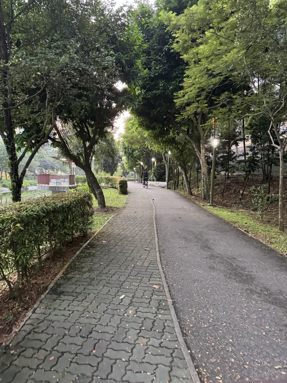
Punggol Promenade Riverside Walk and Punggol Waterway Park are not the same walk. They both offer water views in northeastern Singapore, which is why newcomers often mix them up. The Riverside Walk is the 1.2 km NParks park-connector section near Tebing Lane and Serangoon Reservoir. Punggol Waterway Park is the 25.79-hectare park along Sentul Crescent, set around Punggol’s 4.2 km man-made waterway through the town. One is a riverside edge of Serangoon Reservoir; the other is the landscaped channel linking the town’s reservoirs.
Our original October 2026 photographs cover both settings: Punggol Promenade Riverside Walk near SAFRA Punggol and waterway-side paths, bridges, seating and planting beside Waterway Point. This article compares the places themselves, rather than repeating a general best-parks list. You can use it to choose the right destination for a quiet short walk, understand what you are looking at in the photographs and avoid sending a friend to the wrong waterfront.

The short answer: which Punggol waterfront do you want?
- Punggol Promenade Riverside Walk: 1.2 km; near Tebing Lane and Pasir Ris Industrial Drive 1; NParks describes views over Serangoon Reservoir; wheelchair-friendly section, subject to actual conditions.
- Punggol Waterway Park: the park along Sentul Crescent through central Punggol; NParks lists 25.79 hectares and four zones—Nature Cove, Recreation Zone, Heritage Zone and Green Gallery.
- Why people confuse them: both include Punggol, water, walking paths, bridges and photo-friendly landscapes.
- Photo evidence: October 2026 riverside photos near SAFRA and separate October 2026 waterway pictures beside Waterway Point.
- Riverside access anchor: NParks lists bus stop 65239 (Riviera Station Exit A) and services 3, 50, 83, 85, 381 and 666; verify current routes before travelling.
- Waterway Park rail anchors: NParks lists Punggol MRT and Damai LRT, though the best access depends on the part of this long park you want.
- Do not confuse distances: 1.2 km describes the Riverside Walk park-connector section; 4.2 km is the physical central-town waterway, not a statement that every visitor must walk it end to end.
- Official authority: follow NParks Riverside Walk and NParks Waterway Park, not an undated photo caption.
Why the names matter more than they sound
Imagine telling a relative, ‘I’ll see you at Punggol’s riverside walk.’ That sounds helpful until both of you arrive at different bodies of water. One person might be standing near Waterway Point with the town’s decorative canal in view. The other might have found Tebing Lane and a view across Serangoon Reservoir. Both believe the instruction was correct. The problem isn’t that either person misread a sign: the phrase itself leaves out the essential distinction.
A safer message uses the precise place name and a useful landmark. ‘Punggol Promenade Riverside Walk, near Tebing Lane’ is different from ‘Punggol Waterway Park, beside Waterway Point’. When arranging a family walk, especially with children or older relatives, clarity is worth more than a scenic nickname. Sharing a current map pin from a responsible source can help, but check the place name before sending it.
Two different waters, two different urban stories
NParks describes the Riverside Walk as a part of Punggol Promenade offering views of Serangoon Reservoir. The water body is a reservoir; the promenade follows its edge. The central Punggol Waterway, meanwhile, was designed as a man-made link through the new town, connecting Serangoon and Punggol reservoirs. HDB’s town history explains that this was part of Punggol’s waterfront-town transformation. The waterfronts are related at the regional level, but they are not interchangeable stretches of path.
For a family trying to choose an outing, the difference is practical. At Tebing Lane the experience centres on the reservoir edge and nearby dining. At Waterway Park the experience can involve park zones, landscaped canals, bridges and the built-up town around Waterway Point. The visual difference helps, but the official names and geography are more reliable than simply deciding which photo looks like a ‘river’.
How to recognise the Riverside Walk photographs
Our October uploads labelled Punggol Promenade Riverside Walk include a general riverside view and a second image near SAFRA Punggol. These labels establish which scene the media library intended to document, but do not measure every path’s width or prove a continuous step-free route. They give a visual sense of the water’s edge and the kind of landscape a visitor might encounter in that part of Punggol.
A photograph cannot establish what the view will look like at another water level, season or weather condition. It also does not show whether a particular rest point is occupied, whether a toilet is open or whether a nearby food outlet is trading. Consider it an introduction to the place, not a live status board. For site information that changes, use NParks and the actual signs.
How to recognise the Waterway Park photographs
The Waterway Park photo set includes the landscaped channel beside Waterway Point, a bridge, seating and a water feature along the public path. There is a stronger urban-town-centre context here: mall structures and housing can appear close to the canal. That combination is part of Punggol’s deliberately designed waterfront setting.
These pictures are not necessarily the same viewpoint as the Punggol Promenade reservoir photos. An editor should not combine them into a single unlabelled gallery and call everything ‘Punggol Riverside’. Doing so would remove useful location information. The correct label is part of what makes an archive valuable years after the camera was used.
NParks’ 1.2 km figure belongs to Riverside Walk
The official Punggol Promenade Riverside Walk page, updated in August 2026, describes a 1.2 km park-connector section with reservoir lookout points. It calls the section wheelchair-friendly and places it near Tebing Lane and Pasir Ris Industrial Drive 1. These are specific, checkable details.
That length should not be copied into a guide for every waterfront trail in Punggol. Nor is 1.2 km a guaranteed personal walking distance if you start from your home or extend into another connector. The official figure describes the park-connector section. The total length of your trip includes how you reach it and whether you return by the same route.
The Waterway Park’s 25.79 hectares describe an area, not a route
NParks lists Punggol Waterway Park’s size as 25.79 hectares and its setting along Sentul Crescent. Area and distance describe different things. The 4.2 km waterway’s length is not a measure of the park’s land area, and neither figure tells a parent how long a short visit beside Waterway Point will take.
A student can learn a surprisingly useful data habit here: whenever a number appears in a guide, ask what it measures. Is it the length of a route, the area of a park, the size of the water body or the estimated time for an activity? Copying a correct number into the wrong category creates an incorrect claim. A good local guide keeps the units and their meanings together.
Four Waterway Park zones versus three Promenade sections
NParks names four themed areas at Punggol Waterway Park: Nature Cove, Recreation Zone, Heritage Zone and Green Gallery. Separately, it describes Punggol Promenade as consisting of Riverside Walk, Nature Walk and Punggol Point Walk. These categories are distinct; the four park zones are not subzones of the three promenade sections.
This difference can be confusing when an article casually says ‘explore all of Punggol Promenade’ while showing pictures of the Waterway’s Heritage Zone. The safe approach is to follow the correct park page. Readers interested in the entire promenade can use the site’s Punggol Promenade Guide. Readers interested in the central park can start with Punggol Waterway Park Guide.
What the ‘Nature Walk’ part of Punggol Promenade means
Nature Walk is another named section of Punggol Promenade, not an informal substitute for Riverside Walk. NParks treats Nature Walk, Riverside Walk and Punggol Point Walk as three distinct sections. Someone planning to look for a particular platform or coastal view should know which one the attraction belongs to.
The word nature appears in so many Singapore park descriptions that it can be tempting to use it as a generic label. That makes route advice less useful. Exact names help families find current official maps, identify correct access points and avoid relying on somebody else’s memory of a similar-looking rail or waterfront.
Why the waterfront in the photo looks different from a canal in town
A reservoir edge and a landscaped man-made canal can both be attractive, but their surrounding landforms are different. A wider open-water view often places distant vegetation or a skyline across the water. A town waterway may bring planted banks, bridges and buildings closer together in the frame.
None of this means one is inherently quieter or better for every person. A photograph can be framed to hide a nearby road or include a crowded path. The actual atmosphere depends on time, weather, maintenance and other visitors. Use the visible environment to form a tentative expectation, then follow current site conditions.
A sensible first visit for someone who wants a short walk
If a family wants a manageable reservoir-side outing, the official 1.2 km Riverside Walk description is a useful starting point. They can decide how much of it suits their group’s energy and whether to turn back earlier. A route being listed as wheelchair-friendly does not remove the need to consider personal comfort, weather and current detours.
A family living nearer Waterway Point may find a short look at Punggol Waterway Park more convenient. There is no obligation to cover all four zones in one visit. The real choice is where people want to be, how much they want to walk and how easily they can return. A five-minute pleasant stop can be a successful outing.
Starting from Tebing Lane
NParks identifies Tebing Lane as an adjacent food-and-beverage cluster and lists the Riverside Walk near Tebing Lane and Pasir Ris Industrial Drive 1. Those are useful orientation anchors for the reservoir-side experience. The official access page also includes the Riviera Station bus-stop reference, which can help a visitor use a live journey planner.
Do not assume a photograph proves there is a direct entrance through a particular restaurant, that every outlet is open or that parking is available without restriction. The final route should follow signed public paths. If driving or meeting someone, share a verified public destination rather than an informal ‘behind the café’ instruction.
Starting from Waterway Point
Waterway Point is at 83 Punggol Central, close to Punggol MRT/LRT. The central waterway and park-side paths can be accessed from this broader town-centre setting. For many families it is convenient to combine errands with a short outdoor pause. However, the photograph showing water near the mall is not a map of the only permissible entrance.
Current mall exits, lifts, construction works and park-route signs should determine how you travel from the building to the path. Avoid crossing a road without using the designated crossing simply because you can see the bridge from the window. A visitor with a stroller may need a different approach from someone walking freely.
Where SAFRA Punggol fits
One of the new Riverside Walk images is labelled near SAFRA Punggol. That tells readers which broad stretch the image represents. It does not guarantee a specific current entrance, booking availability or public access to every indoor SAFRA facility. The photograph shows the surrounding corridor, not an admission ticket.
If a family is pairing a riverside walk with a SAFRA activity, they should check the chosen facility’s own operating rules. Sports, recreation and membership programmes can require booking or eligibility conditions distinct from NParks’ public park connector. Never infer these from a picture of a nearby footpath.
What the new Riverside photos can and cannot tell us about accessibility
NParks describes the Riverside Walk as wheelchair-friendly. That is an official characterisation of the section, but individual journeys also involve transport access, kerbs, crossings, changing works and personal mobility needs. The photographs alone cannot establish the entire experience or prove every metre is comfortable for every visitor.
A practical plan identifies the intended start and end points and checks current ground conditions. A wheelchair user should be able to decide which route meets their needs, rather than be told that a blanket ‘accessible’ label settles everything. Ask relevant authorities about a particular barrier if needed. Accessibility is experienced, not simply advertised.
What the Waterway Park official page says about accessibility
NParks describes Punggol Waterway Park as wheelchair accessible and elderly friendly. These are helpful official categories, but the park is large and the practical route will vary by entrance. A person with limited walking endurance may prefer a short return journey near one section rather than a long loop across bridges.
For families, keep the plan flexible. If a bridge approach is uncomfortable or a path is temporarily blocked, follow official alternative signage and change the outing. A photograph from October 2026 cannot certify access on a later date. We should never promise a step-free path based on one beautiful view.
How to plan with a stroller
A stroller changes the importance of kerb transitions, path width and places to pause. Choose the segment that suits the family’s needs and check actual access before setting off. Don’t assume that a distance listed as 1.2 km will feel equally short for an adult carrying an additional child or heavy supplies.
If the child wants to leave early, let the outing be short. A waterfront walk should provide relaxation, not become a race to complete a printed route. A caregiver may benefit from carrying a small drink and sun or rain protection while avoiding unnecessary equipment that makes the return journey awkward.
Waterfront safety is not the same as a playground barrier
Waterfront paths can be pleasant, but the proximity of water changes supervision needs. Keep younger children within appropriate reach, observe signs and do not encourage them to climb railings for photographs. A child seeing birds or reflections may move suddenly; adults should focus on supervision rather than looking only through a phone camera.
Never enter the water or allow unauthorised fishing or water activities simply because another person appears to be doing them. The exact rules depend on the location and the relevant authority. NParks specifically notes that fishing is not allowed in Punggol Waterway Park. For designated angling locations elsewhere, consult current NParks and PUB information rather than assume the two waterfronts share identical permissions.
What to do if the weather turns bad
Punggol’s open paths can feel very different in heavy rain, thunderstorms or intense heat. The view shown in a clear photograph is not evidence that the same journey is suitable when lightning is nearby. If a thunderstorm develops, seek a proper building shelter and follow the relevant official safety guidance rather than remain under a tree or exposed platform to finish a walk.
Check current forecasts and weather alerts before an outdoor family visit. It is sensible to shorten or postpone a nonessential outing. A waterfront photo will still be there for another day; safety is not something to trade for a particular angle of the reservoir.
The difference between shade and shelter
Tall trees, buildings or an overhead structure can create shade. That does not necessarily protect a person from wind-driven rain or lightning. Similarly, a wide open waterfront photo may look cool because the water is blue, yet the path could be hot in strong sun.
Make the plan for the actual weather, not the colours in the photograph. Bring appropriate sun protection and drinking water, and allow older relatives or young children to set a comfortable pace. A short outing that ends before exhaustion is often better than following an ambitious route simply because a map calls it easy.
Why photography at the reservoir deserves extra care
A scenic water view encourages people to move toward the edge for a better composition. Stay behind barriers and on public paths. Don’t climb railings, obstruct cyclists or stand in a route just to capture reflections. The photograph is not worth entering a restricted area or creating risk for other visitors.
Consider the privacy of people using the promenade. A wide scene can show the character of the place without identifying strangers or children. Keep the horizon and path as the subject. The same principle applies whether the scene is the reservoir, canal or a footbridge near Waterway Point.
A photograph’s upload date is not a water-level measurement
The images are October 2026 media records. They capture what was visible to the camera, but their existence does not establish reservoir level, flow rate or the time of a specific rain event. Water surfaces change with weather and management, and reflected colours change with lighting.
An older student studying Geography or Science should distinguish observations from measured data. A picture can suggest that the surface looks calm at one moment, but cannot justify a statement about safe swimming or constant water quality. Use PUB and other official sources for those questions.
Reservoirs and the man-made town waterway: a science connection
HDB explains that the new town’s man-made waterway was created as part of its waterfront development and connected the dammed waterways of Serangoon and Punggol reservoirs. This reflects an integrated landscape approach in which water infrastructure and recreation coexist.
But water connection does not mean visitors should treat every part of the system identically. Different sections have distinct public-use rules and functions. For a student, the safe lesson is that a system may be connected physically while its access conditions vary. A reservoir edge, landscaped town waterway and designated fishing point are different settings.
A Mathematics exercise using the official figures
Imagine a student comparing the Riverside Walk’s official 1.2 km length with the 4.2 km physical length of Punggol’s central man-made waterway. The second is 3.5 times the first if we compare the two numerical lengths. That calculation is correct, but it does not tell us which outing takes 3.5 times longer. A visitor rarely walks exactly along the water’s full physical length without detours.
The more important lesson is interpreting what the units refer to. One number is a park-connector section length; another is a waterway’s physical length. Students can practise saying the comparison aloud with those labels intact. When a word problem includes a number, the context is part of the calculation.
A map-reading activity for older children
Draw a simplified diagram with a town waterway, a reservoir, a shopping mall and a path. Ask the child to match the correct place name to each photograph before adding any route. Then compare the diagram with NParks’ current published maps. The goal is not an exact survey drawing but an understanding of how places connect.
Have the child mark which parts are known from the photo, which come from the official source and which still require verification. A map that makes the differences visible is more useful than a beautiful drawing that labels everything ‘Punggol waterfront’. This exercise also helps with school geography source-based questions.
An English composition exercise based on two photographs
Show a student one Riverside Walk photo and one Waterway Park photo. Ask them to describe each with specific nouns rather than repeating ‘nice river view’. They might describe a reservoir-side promenade in one and a landscaped town canal near shopping buildings in the other. The exact visible detail should guide the vocabulary.
Next, ask for a comparison sentence that does not invent a sound, smell or emotional response the photographer never reported. ‘The first photograph appears more open, while the second shows more nearby buildings’ is a responsible visual comparison if the selected frames support it. ‘Everyone prefers the first place’ is not.
What about Punggol Promenade Nature Walk?
Nature Walk is a separate promenade section. NParks lists it as another waterfront trail rather than as an informal continuation of the same 1.2 km Riverside Walk label. It is possible for people to connect parts of the wider green network, but a writer must distinguish official section names from a personally chosen route.
If a family hopes to continue toward Coney Island or another promenade section, use a current NParks map and check real access. Do not infer a simple continuous walking time from the two photographs in this article. The route may be longer and include different junctions, weather exposure and facility arrangements.
What about Punggol Point Walk?
Punggol Point Walk is another component of the larger promenade and offers a different coastal context. NParks separately identifies it; it is not a rebranding of the Riverside Walk near Tebing Lane. The three thematic sections have their own lengths and views.
A visitor who wants the jetty or views toward the Johor Strait should look for Punggol Point Walk rather than assume those sights are on the Riverside Walk’s 1.2 km stretch. This is exactly the kind of confusion this comparison exists to prevent. One destination name can save a very long wrong walk.
What about Punggol Park?
Despite its name, Punggol Park is a separate park in the Hougang area. It should not be confused with Punggol Waterway Park, which is along Sentul Crescent in Punggol town. A newcomer searching simply for ‘Punggol park’ can easily land on the wrong result.
Before arranging a meetup, check the full official name and address. Singapore’s place names often preserve geography and history in ways that do not match a casual assumption. The safest habit is to search for the exact NParks listing you need.
Why walkers and cyclists may experience the same route differently
Park connectors are used for movement as well as recreation. A person strolling slowly and a rider moving through to another destination have different speeds and needs. Follow current path markings and shared-path etiquette. Do not occupy the full path for a group photograph or stop abruptly without checking what is behind you.
LTA and NParks provide public guidance on considerate active mobility and use of park connectors. A family with a stroller should choose a comfortable area to pause. Cyclists should slow where people gather and comply with posted controls. A scenic path remains a shared public route even when the water looks beautiful.
What the photos leave outside the frame
The Riverside image does not show every access point, while the Waterway image may emphasise a bridge and not the wider park. A single frame also cannot reveal where a toilet is, what happens after the next bend or how busy the path becomes later. That is normal for photography, but poor directions occur when writers treat the frame as a complete map.
A useful article pairs image evidence with the authority responsible for the place. NParks provides the route and park information; a photo helps readers recognise the scene. Neither should be forced to answer questions it cannot answer well.
A simple outing plan for three generations
Before setting off, ask which kind of waterfront each person wants. A grandparent may prefer a short reservoir-side view without covering the whole trail. A younger child may enjoy the Waterway Park landscape and an easy meal afterward. Choose the location that suits the group rather than insisting one trail is objectively superior.
Allow travel time, accessible routes and the option to stop early. Don’t promise that every rest seat will be empty or that every café is open. For a relaxed family outing, a clear destination and flexible return plan usually matter more than adding multiple photo stops.
Why a return route should be planned before the first step
On a long waterside corridor, walking out feels easy because everything ahead is new. The return can feel much longer when a child becomes tired. Decide in advance whether to turn back at a convenient point or complete a route with a verified onward connection. A segment’s full official length is not necessarily the distance your family must cover.
With a stroller or mobility aid, consider crossing and lift arrangements as well as distance. If there is a temporary closure, follow the official detour rather than invent a shortcut along a bank. A safe route is one whose end you understand before you begin.
The difference between a path and a water activity
Walking beside water does not grant permission to swim, paddle, fish or enter planted areas. For Punggol Waterway Park, NParks explicitly states that fishing is not allowed. Other waterfront areas may have designated activities under different rules, but the photograph alone never provides a licence.
Teach children the distinction without making the outing frightening: ‘We can enjoy looking at the water from the path; entering it is different and needs its own rules.’ A thoughtful family can appreciate the water landscape while respecting the infrastructure and habitats that support it.
How Punggol’s waterfront changes through the day
Lighting affects the appearance of water and planted banks. The same bridge may look very different in late afternoon from early morning. Crowding also changes as people finish work or school. A photographer’s choice of timing can make one place look secluded even when it receives many visitors at other times.
Do not infer a guaranteed ‘quietest hour’ from the images. If a low-stimulation visit matters, choose a flexible plan and be prepared to leave when the environment no longer suits the family. Everyday conditions are dynamic; the site name and official route are the more durable facts.
A brief documentary exercise: label the two scenes
At home, give a child two captions with the place name removed. The first shows a reservoir-side route near Tebing Lane; the second shows a canal path beside Waterway Point. Ask what clues would help identify them and what evidence is missing. The answer should include location context, not only the appearance of the water.
Then reveal the original media titles and check them against NParks. This exercise demonstrates why public-facing captions need precise geography. Two places can look similar while leading visitors in very different directions.
A final choice without a winner
If you want the official 1.2 km reservoir-side section near Tebing Lane, choose Punggol Promenade Riverside Walk. If you want the landscaped central-town waterway with park zones and routes near Waterway Point and Sentul Crescent, choose Punggol Waterway Park. Both are legitimate places to enjoy, and neither requires an extravagant itinerary.
The real success is knowing which one you selected, getting there safely and letting the people with you set a comfortable pace. A photograph can inspire the trip. The official name and current directions make it work.


Frequently asked questions: Riverside Walk versus Waterway Park
Is Punggol Promenade Riverside Walk part of Punggol Waterway Park?
No. They are distinct NParks-listed places within the wider Punggol green network, although other park connectors link parts of the region.
Where is Riverside Walk?
NParks places it near Tebing Lane and Pasir Ris Industrial Drive 1, along Serangoon Reservoir.
How long is Riverside Walk?
The official park-connector section is listed as 1.2 km.
Where is Punggol Waterway Park?
Along Sentul Crescent Road, cutting through central Punggol.
How large is Punggol Waterway Park?
NParks lists a park area of 25.79 hectares.
Is the central waterway 4.2 km?
HDB describes Punggol’s man-made town waterway as 4.2 km long. That is the waterway’s physical length, not the length of every particular path.
Which location is near Tebing Lane?
Punggol Promenade Riverside Walk.
Which location has the four themed park zones?
Punggol Waterway Park, with Nature Cove, Recreation Zone, Heritage Zone and Green Gallery.
Which is closer to Waterway Point?
The photographed canal beside Waterway Point is part of the central Punggol Waterway Park setting. Your actual walking route depends on the entrance.
Is Riverside Walk wheelchair-friendly?
NParks lists it as wheelchair-friendly. Check your exact start, end and current route suitability.
Is Punggol Waterway Park accessible?
NParks lists the park as wheelchair accessible and elderly friendly. Individual segments and approach paths still matter.
Can I fish at Waterway Park?
NParks says fishing is not allowed in Punggol Waterway Park. Other designated fishing areas have different rules.
Does Punggol Promenade have other sections?
Yes. NParks distinguishes Riverside Walk, Nature Walk and Punggol Point Walk.
Can I get to Riverside Walk by bus?
NParks lists services 3, 50, 83, 85, 381 and 666 at stop 65239, Riviera Station Exit A. Confirm live route information.
Is Punggol Park the same as Waterway Park?
No. Punggol Park is a separate park in Hougang. Punggol Waterway Park is in Punggol town.
Are the new photos from exactly the same spot?
No. The image library labels a reservoir-side Riverside Walk cluster and a separate Waterway Park cluster.
Can photographs verify weather or safe water quality?
No. Photographs show visual conditions at a moment; weather and water-quality decisions require current official information.
Can I combine both in one afternoon?
That is a personal route-planning question involving transport and energy. This article does not promise a continuous short walking route between them.
Which guide should I use for detailed Riverside Walk directions?
Use the dedicated Riverside Walk and Punggol Promenade guides linked below, then current NParks information.
Which should a family choose?
Choose by the exact waterfront and route you want, access needs, travel distance and weather—not by an unsourced ‘best’ ranking.
Official sources, photo record and onward reading
- NParks — Punggol Promenade Riverside Walk (2026 information).
- NParks — Punggol Waterway Park (location, size, four zones and rules).
- HDB — Punggol town history and the 4.2 km man-made waterway.
- NParks — Nature Walk at Punggol Waterway Park.
- Punggol Promenade Riverside Walk near Tebing Lane — existing local guide.
- Punggol Promenade Guide — all three sections.
- Punggol Waterway Park Guide — central-town park zones.
- Complete Punggol Guide.
Editorial review: 23 October 2026. Featured and inline images come from the site’s original October 2026 uploads and are labelled by the two distinct locations. NParks’ current public pages take priority for route names, distances and visitor rules. This is an explanatory comparison, not a real-time closure feed or a promise that a specific walking path or business is open.


