
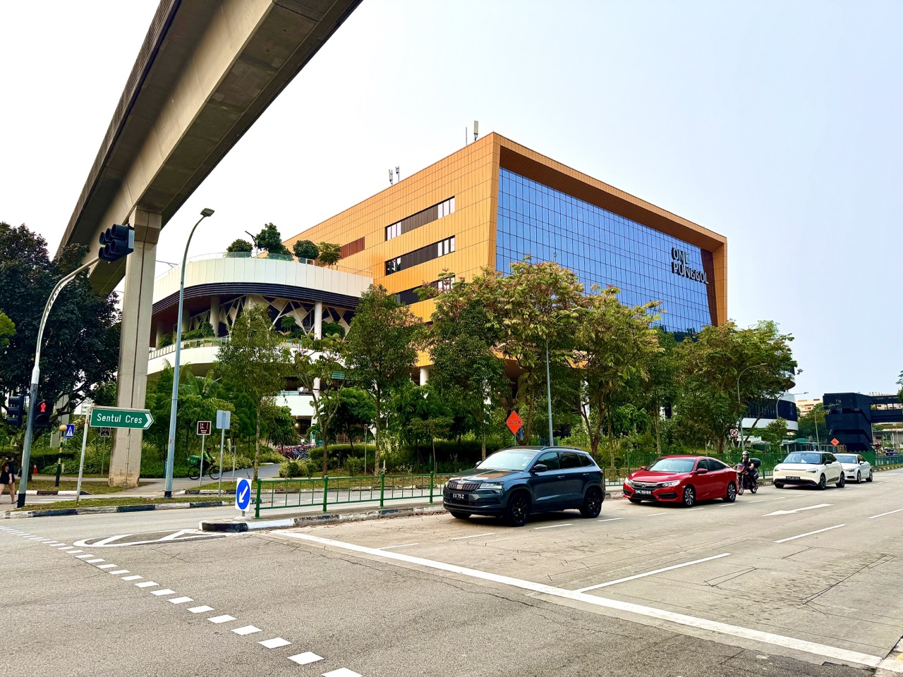
Punggol Drive runs through one of the town’s most interesting everyday transport settings: road traffic below the elevated Punggol LRT, with One Punggol community hub close by. Two newly uploaded October 2026 photographs show the road, vehicles at a junction, the overhead rail infrastructure and the hub in the background. They are ordinary street scenes, but they explain how several kinds of movement meet in a compact part of Punggol.
For families, the practical point is simple: the shortest-looking line between the MRT, LRT, One Punggol and a nearby destination is not necessarily the safest pedestrian route. The right journey uses designated crossings and current wayfinding, respects path markings and makes room for slower walkers and people using mobility aids. This article explains what the photographs can teach about crossing and route planning without inventing a precise junction geometry, a traffic-light phase or live travel times that the pictures do not establish.

Punggol Drive near One Punggol: quick orientation
- Photographed setting: public roadway on Punggol Drive with elevated LRT tracks and One Punggol visible in the background.
- One Punggol’s official address: 1 Punggol Drive, Singapore 828629.
- Nearby public transport context: Punggol MRT/LRT and Sam Kee LRT serve the wider town-centre area; choose the actual origin and destination before deciding a route.
- Road safety rule: use the designated legal pedestrian crossing; do not cross because traffic happened to be stopped when a photo was taken.
- Signals: LTA explains that a steady green pedestrian signal is for starting a crossing; do not start when the green man is flashing.
- Path distinctions: pedestrian-only paths, ordinary footpaths, cycling paths and shared paths have different rules under LTA’s active mobility framework.
- Photograph limitation: a street scene cannot identify the exact bus service, road signal timing, temporary diversions or authorised pickup place.
- Best visit: read current signs and take a comfortable safe route rather than walking directly beneath the visual landmark wherever the pavement is uncertain.
For policy and location grounding, see the People’s Association One Punggol contact page, LTA’s road safety guidance, traffic-signal explanation and pedestrian-only path changes. The existing Punggol Transport Guide covers the wider transport network; this page stays with the specific street scene and how to read it.
Three levels of movement in one photograph
The LRT uses elevated infrastructure to move passengers across the town. Cars and other road users occupy the carriageway below. Pedestrians move between the buildings, crossings and transport nodes at ground level. A single photograph allows us to observe these different layers in one frame, making the urban design clearer than a list of road names alone.
But the three layers do not all follow the same logic. A train runs within a controlled rail system; road vehicles obey signals and road rules; pedestrians use footpaths and crossings. Seeing them stacked visually does not mean they can cross or change directions anywhere they want. The street works only when each layer respects its designated connections.
Why One Punggol belongs in the photograph
One Punggol, the community hub at 1 Punggol Drive, helps viewers locate the scene. The building brings together public services, a library, hawker dining and community activities, so different visitors may be heading to it for different reasons. Someone going to lunch may not choose the same route as a parent with a stroller or a student transferring between rail and an after-school activity.
The building’s address is a reliable destination label, but a photograph with its facade in the background does not mark every entrance, lift or legal crossing. Begin with the destination, then work through the current street-level wayfinding. Avoid treating the building as permission to cross the nearest part of the road.
What stopped cars do not prove
Our image shows vehicles waiting at a road junction. That observation does not reveal why each vehicle is stopped, the sequence of signal phases or whether all directions of traffic are simultaneously at rest. A vehicle may be stopped at a light while other turning movements remain possible. Pedestrians should never infer that the road is safe to cross simply because one lane looks stationary in a photograph.
Traffic can change within seconds. The safe approach is to use the actual marked crossing and observe present signals and moving traffic. This is especially important when walking with children, who may interpret a line of stopped cars as a permanent obstacle rather than a temporary condition. Explain what to check in real time instead of teaching them to copy a frozen moment.
Finding the correct pedestrian crossing
Look for a legitimate zebra crossing, signalised pedestrian crossing, footbridge or underpass appropriate to the route. Do not create your own crossing point because it shortens the walk. LTA’s road safety guidance describes crossing markings and features designed to make pedestrians visible and remind motorists to yield.
If you’re unsure whether a crossing is signalised or uncontrolled, read its actual signs. A photograph supplied for a neighbourhood article is not a crossing inventory and should not be used to identify the legal features at a precise junction without verification. Find the designated crossing and follow the rule attached to it.
A zebra crossing is not the same as a green-man crossing
At a zebra crossing, pedestrians have priority over approaching vehicles, but still need to check that drivers can and will stop safely. At a signalised crossing, the pedestrian signal tells people when to begin. The difference matters because the same cautious behaviour does not mean ignoring the traffic system. Parents should name the type of crossing they are actually using and explain its signals.
Never tell children that ‘cars must stop, so we can just go’. Drivers can make mistakes, and visibility varies. A safer instruction is to use the proper crossing, look and make sure the conditions are safe before moving. The goal is confidence built on an accurate understanding of the system rather than blind trust.
Green man and flashing green man: a crucial distinction
LTA explains that the steady green pedestrian signal is the period for people at the kerb to start crossing. The flashing green signal is intended to allow pedestrians already in the crossing to finish. Someone who arrives after the green man begins flashing should not step out to start; there may not be sufficient time to reach the far side safely.
That detail is important when an adult is moving more quickly than a small child. Do not rush the child into the crossing just to avoid waiting for another cycle. If you’re not sure you can start during the steady phase, wait for the next one. A minute spent waiting is far less important than completing the journey safely.
Why some crossings have push buttons
At some Singapore signalised crossings, a pedestrian push button registers the intention to cross. LTA explains that the GLIDE traffic-signal system uses demand information to manage signals across the network. A green pedestrian phase may therefore not appear immediately when someone reaches the kerb; the signal process can involve a wait.
Teach a child to press the appropriate button where one is provided and then wait for the correct indication. Repeatedly pushing it in frustration won’t necessarily accelerate a traffic system. A person should not cross against the signal because they believe the button is not working. If equipment appears defective, follow the safe existing route and report the issue through a suitable authority.
Green Man+ and people who need more crossing time
LTA’s Green Man+ system is intended to provide extra green-man time at equipped crossings for eligible senior pedestrians and persons with disabilities. LTA has described an extension of up to thirteen seconds at some locations. That is system-level information, not proof that the particular photographed Punggol Drive junction has the feature installed.
If somebody in your group moves slowly, check the actual crossing for the relevant facility and allow enough time. Do not pressure them to hurry into a flashing phase. The best journey may use a different suitable crossing or route. Accessibility is not established by the presence of a traffic light alone.
Why traffic signals cannot eliminate every hazard
Signals coordinate movements, but human attention still matters. Vehicles may be turning, people may be distracted and sightlines can vary near columns, buses or parked vehicles. LTA describes features that remind turning motorists to look for pedestrians, but those measures complement rather than replace careful crossing.
A family can practise the habit of checking the full crossing rather than watching only one direction. Keep younger children close, put phones away and do not walk into the road while looking backward to admire the LRT. The overhead train may be interesting, but the immediate crossing deserves the visitor’s attention first.
The elevated LRT as a landmark, not a pedestrian instruction
The viaduct helps visitors recognise this part of Punggol. People may use it as a reference when discussing the route toward Sam Kee or the main MRT station. However, an overhead track is not a pedestrian path and cannot be followed blindly through every piece of land below. At certain points there may be landscaped areas, columns, fences, courts or other facilities.
Use the legal ground-level paths and signs instead of assuming that ‘keep the tracks overhead’ is enough. A direct-looking line beneath the viaduct could end at a barrier or crossing. A child learning geography may enjoy the track as a long linear feature; an actual journey still needs a safe, verified route.

Sam Kee LRT and the local recreation corridor
Sam Kee LRT is a nearby rail reference for the One Punggol area. There is also a community-space story along the corridor, including Punggol Green and recreational areas below the viaduct. This can make the neighbourhood feel connected, but the transport setting and recreation setting are not one undifferentiated path.
The Punggol Green beneath the LRT guide covers courts, playgrounds and shared space. This article is specifically about road-edge decisions near One Punggol. It focuses on crossings, safe movement, the legal path types and how to navigate when a destination is visually close.
Pedestrian-only paths and shared paths
Singapore has different paths for different kinds of users. LTA’s pedestrian-only path initiative introduced markings on some footpaths adjoining dedicated cycling routes. These marked pedestrian-only paths are different from shared paths where both pedestrian and cyclist symbols appear. The rules for bicycles, non-motorised scooters, powered devices and mobility aids are not identical.
Do not judge legal path status from pavement colour alone. Look for current logos, signs and physical features on the section you are using. A person with a child on a scooter should check whether that type of scooter is permitted in the specific path. If unsure, slow down, stop safely and read the signs rather than assuming all wide paved routes are shared.
What has changed in active mobility rules by 2026
LTA began enforcement of restrictions on cycling and non-motorised personal mobility devices on converted pedestrian-only paths from July 2025. Separate rules govern other devices and path types. A route that permitted a certain behaviour years ago may carry new markings and restrictions. Readers must use current notices and LTA guidance rather than old cycling maps.
This is why we don’t mark an exact ‘scooter route’ across the scene in the October photographs. The images may not show every path logo or sign. A safe, lawful route depends on what is actually marked at the site and the type of device being used.
Children on scooters near One Punggol
Our separate One Punggol plaza photographs show children using scooters in a public open space, but this road-junction photo guide should not be read as granting permission to ride a scooter on every surrounding pavement or road. Legal status varies with device type and path designation. A playground, plaza and pedestrian-only strip may have different operating rules.
For young children, adult supervision is especially important near road crossings. A child may turn suddenly toward the open area they recognise. Stop before the kerb, discuss the crossing and only proceed when safe. If a device cannot be used safely or lawfully for the next segment, dismount and move it appropriately.
Shared routes need more than a painted line
A line painted on a path helps organise movement, but it cannot prevent every collision. Pedestrians may stop to look at a sign, cyclists may approach from behind and families may move across a path to reach a crossing. Good behaviour includes awareness, a reasonable pace and giving other users space.
Don’t take a group photograph while standing across the active path. Move to a suitable stopping area first. A person using a wheelchair or walking aid may need a clear, predictable width, so keep bags and bicycles off the travel route. The ideal path works for people who are not part of your group too.
Crossing with a stroller
Pushing a stroller changes the amount of space and time needed to cross. Avoid stopping in the carriageway to adjust the hood, search a bag or take a photo. Do those tasks safely on the pavement before beginning. Use the marked crossing and wait for an appropriate pedestrian phase, allowing time to move at a comfortable pace.
Where kerbs or temporary works make a crossing difficult, look for a suitable legal alternative. This article does not verify every dropped kerb or access point in the photographs. Plan according to the actual stroller, child and route. A slightly longer accessible path is often preferable to improvising on an unsuitable edge.
Crossing with a grandparent
An older person may prefer a calm pace, fewer turns, a known route and an opportunity to rest. Ask them what makes the journey comfortable. Do not assume they need to be hurried or that the shortest straight-line path is best. Signalised crossings provide a controlled pedestrian phase, but its timing and any special assistance should be checked at the actual location.
If a group reaches the crossing just as the green signal flashes, wait together rather than splitting across the road. This protects the group and avoids the anxiety of being separated by traffic. The most considerate person in a family journey often determines the best pace.
Crossing with a child travelling after school
Schoolchildren eventually learn to navigate streets with increasing independence. A responsible plan introduces a familiar route, safe crossing sequence and clear contingency when buses are delayed. The adult can ask the child to identify the correct crossing and explain why a flashing green man is not a signal to start. This is more useful than simply repeating ‘be careful’.
Do not ask a pupil to prove readiness by making an unsupervised trial journey before the family and school have agreed it is appropriate. Independence develops through judgement, practice and reliable communication, not an artificial test. If the route involves a busy junction, adults should verify that the child’s understanding matches real conditions.
A walking route is a sequence of choices
A digital map may display a continuous coloured line, but the person walking it experiences several decisions: which side of the road, which crossing, which entrance, where to turn and whether a path is obstructed. A safe route description should identify these decisions without assuming that the map is completely up-to-date.
For example, ‘walk to One Punggol’ is a destination request, not a full route. A practical instruction adds an actual starting point, legal pedestrian crossing and the intended public entrance. But because temporary changes occur, the final authority is the current wayfinding and physical environment.
What if temporary works change the usual way?
Road maintenance, building works and event arrangements can change pedestrian access for a period. Do not step around a barrier simply because a familiar map shows the former route. Look for the official diversion and follow staff or signage where present. An area that appears clear beyond a fence may still have hazards or restricted access.
Plan a little extra travel time when the group is unfamiliar with the area. If a normal crossing is unavailable, find the signed legal alternative. It is acceptable to change the destination or postpone a visit when a suitable route cannot be identified, particularly with young children or someone who needs accessible access.
Road edges are not meeting points
At One Punggol, relatives may say ‘wait where you can see the building’. That is too vague. Someone might stand near a traffic junction or on a path used by many people. Choose a public, recognisable spot outside the road crossing and away from entrances or moving traffic, and give the correct full address privately.
A useful meeting point permits the group to pause without obstructing other users. If one person is late, the rest should not drift toward the carriageway to search for their vehicle. Agree on how to communicate safely while stationary. Waiting responsibly is part of route planning.
Cars, taxis and the danger of interpreting a traffic photo
A photograph with cars in it cannot tell readers where a taxi or private-hire vehicle may lawfully stop. LTA road markings distinguish prohibited parking and limited pickup conditions. The place where a car is seen waiting in traffic is not evidence of a designated passenger drop-off.
If you are arriving by vehicle, use the appropriate confirmed pickup or parking information for the destination and obey local signs. Never advise a driver to stop at a junction or on a pedestrian crossing. A group should avoid dashing through moving traffic toward a waiting car, however convenient the apparent shortcut.
The junction as a lesson in systems
A road junction balances movements that would conflict if everyone tried to pass at the same time. Vehicle signals allocate turns; pedestrian signals provide crossing opportunities; the LRT carries passengers on a separate elevated level. The physical structure and the timing system work together to help different users navigate the same urban area.
Students can describe this as a coordination problem rather than saying that one group simply has priority everywhere. For a deeper question, ask why signal timings might consider pedestrian and vehicle demand. LTA’s GLIDE explanation introduces a real example of a managed transport system without requiring students to collect unsafe live measurements from a junction.
What a Primary 2 pupil can learn from this scene
Begin with visible objects: road, cars, rail track and building. Ask which one carries people above the ground and which carries people at street level. Then talk about one important rule: we cross at the designated crossing, not wherever we see a gap. Keep the conversation simple and never position a child in the road to illustrate an answer.
At home, let the child draw a safe street scene from memory and use words such as ‘above’, ‘below’, ‘beside’ and ‘across’. If the child adds a crossing that is not present in the photograph, distinguish the drawing’s imagined part from the observed picture. That small distinction introduces the idea of evidence.
What a Primary 5 pupil can learn about map scale
A wide photograph can make two landmarks appear almost touching, even when the pedestrian route between them includes a longer path. Perspective changes how distances look. A map also reduces real distances according to scale. Children can compare both representations without using either as a guaranteed walking-time calculator.
To practise, take two hypothetical routes of 350 metres and 480 metres. The second is 130 metres longer, but it might still be more suitable if it includes a safer crossing or accessible path. Those distances are invented teaching numbers, not measured routes from the pictured location. The key learning is that shortest distance and best route are different questions.
What a Secondary Geography student can investigate
Geography students can ask how an integrated transport landscape serves different users. The photo supports observations about elevated rail, road space and the nearby community hub. Students might then research pedestrian connectivity, accessibility and land use through official sources, clearly separating photographed facts from wider planning aims.
A responsible fieldwork plan stays away from the carriageway and does not identify individual commuters. It could compare one official map with the photo and list uncertainties: precise signal layout, legal path marking and temporary barriers. Such limitations are not failures; they show why public-space analysis requires more than one form of evidence.
An English exercise: writing a precise caption
Compare two captions: ‘Cars stopped at a Punggol Drive junction under an LRT line’ and ‘The main Punggol junction is always gridlocked.’ The first is supported by the photograph’s basic description. The second makes an unverified claim about frequency and the whole transport network.
Ask the student to rewrite the exaggerated sentence with a time limit and uncertainty. ‘Several cars were waiting at the junction when this photograph was taken’ is a stronger factual statement. Precise language makes an article more trustworthy, and it helps readers avoid treating a single image as a permanent traffic report.
Rain changes the way the scene is experienced
A junction viewed from a comfortable indoor screen is very different from a crossing during heavy rain. Wet surfaces can be slippery, visibility may be reduced and families may need more time. An overhead viaduct does not guarantee continuous shelter along all paths or make outdoor walking safe during lightning.
Carry appropriate rain protection, allow time and follow official safety warnings. If a crossing or walkway is flooded, do not assume it is safe because cars are still using another part of the road. Use a suitable legal alternative and postpone nonessential travel if necessary.
Heat and fatigue matter too
In Singapore’s hot and humid conditions, even a short journey can feel harder when carrying a school bag, pushing a stroller or accompanying an older person. A route with a comfortable place to pause may be preferable to a slightly shorter but exposed or awkward approach. The photographs do not establish shade coverage or seating along every route.
Prepare water as appropriate, choose a manageable pace and pay attention to how the people in your group feel. A family meeting for lunch at One Punggol does not need to treat walking speed as a competition. The entire point of a connected town centre is to make everyday activities usable, not exhausting.
Emergency access must remain clear
Traffic junctions, drop-off areas and main walkways may also be used by emergency or service vehicles. Keep road shoulders, marked crossings and access points clear. Don’t gather for photography in a place that blocks responders or causes drivers to make sudden manoeuvres. If an incident occurs, follow official emergency directions.
A person witnessing a hazard should report it through the proper public channel rather than attempting risky interventions in moving traffic. Parents can teach children that helpfulness includes stepping back when a scene needs trained personnel. Public safety depends on knowing the limits of what a pedestrian should do.
The ethical use of everyday street photographs
Our images are useful because they depict the road and buildings, not because they allow us to investigate individual drivers or pedestrians. A car seen waiting in one frame does not establish the driver’s intentions, destination or compliance with every rule. Avoid publishing readable private information or speculating about the occupants of vehicles.
Photographing a public street may be lawful in many circumstances, but the method still matters. Do not stand in traffic, block a pedestrian route or take invasive images of children. A wide architectural view can communicate the street’s layout without creating unnecessary privacy risks.
A calm route rehearsal for visiting One Punggol
If you are unfamiliar with the area, make a practice journey at a low-pressure time. Begin at your actual origin, check the current route and identify where you will cross. Find the building’s public entrance without cutting through restricted areas. Then imagine how the same route might feel at the time of your actual appointment.
A rehearsal can reveal whether a curb, lift or path is suitable for your group, but conditions may still change later. Save a reliable address and relevant contact details. For information about library, hawker and community-club facilities once you arrive, see the dedicated One Punggol Guide.
A one-page family crossing routine
Before setting off, identify your destination and legal pedestrian route. At the crossing, stop at the correct place, check the actual signal and watch traffic. Start only when the crossing permits it and it is safe. Keep moving calmly rather than running or stopping to take photographs in the road. Once safely across, step aside before using a phone or looking at the map again.
Repeat the routine in ordinary situations, not as a frightening lecture. Children are more likely to remember what adults model consistently. If the group is uncertain, pause on the pavement and clarify the next step. This turns a complex transport environment into a sequence of manageable decisions.
Frequently asked questions
Where is the photographed Punggol Drive scene?
The uploaded photo captions place it on Punggol Drive near One Punggol, with elevated LRT tracks visible. They do not independently establish an exact junction coordinate or signal arrangement.
What is One Punggol’s official address?
1 Punggol Drive, Singapore 828629, according to the People’s Association.
Does the elevated LRT provide a walking route beneath it everywhere?
No. The rail line is a landmark; legal walking routes depend on the actual paths, barriers and crossings on the ground.
Can I cross when the photographed cars look stationary?
No. Photographs freeze a moment and cannot establish current road conditions or legal crossing permission.
When may pedestrians start at a signalised crossing?
When the pedestrian signal gives the steady green phase and crossing is safe. Do not begin after the green man starts flashing.
Does a flashing green man mean hurry and begin?
No. LTA explains that the flashing phase is for pedestrians already crossing to finish.
Is a zebra crossing the same as a traffic-light crossing?
No. The legal control and cues differ. Use the rules and road conditions at the actual marked crossing.
Can older pedestrians get extra crossing time?
Some equipped signalised crossings offer Green Man+ extensions for eligible people. This article does not verify which features are fitted at the pictured junction.
Can children ride scooters on any pavement there?
No. Permitted devices and speeds depend on whether a path is pedestrian-only, a footpath, cycling path or shared path, and current restrictions.
Can bicycles use pedestrian-only paths?
Not where LTA’s converted pedestrian-only path restrictions apply. Follow current markings and official rules.
Are the photographed roads safe for a child to cross independently?
A picture cannot assess an individual child’s readiness, current traffic or the exact safe route. Families should plan and practise appropriately.
Is the approach fully step-free?
That is not verified from the images. Check the current route’s kerbs, ramps, lifts and any diversions for specific mobility needs.
Can a taxi stop where a photographed car is standing?
The image does not establish a legal pickup area. Follow current road markings and the destination’s proper pickup directions.
Is the junction always congested?
No such claim follows from one image of vehicles waiting. Live traffic conditions vary.
Can I take photographs under the LRT?
Use lawful safe public viewpoints, don’t enter restricted spaces and avoid obstructing traffic or pedestrians.
Does the rail line lead directly to Sam Kee?
The wider area connects with Sam Kee LRT, but an overhead track does not tell pedestrians which crossings or paths to use. Confirm an actual route.
What should I do if roadworks block my normal path?
Follow official pedestrian diversions and barriers; never walk through a work zone to follow an outdated map.
Where can I read about the recreation spaces beneath the viaduct?
Use our separate Punggol Green photo guide, which covers courts, playgrounds and the Sam Kee corridor.
What if a crossing signal appears faulty?
Do not cross against the signal or take unnecessary risks. Use a safe legal alternative and report the issue through an appropriate authority.
Why is this a useful learning photograph?
It shows transport layers and prompts precise discussion of routes, evidence, safety and different public-space users.
Sources and connected Punggol guides
- People’s Association — One Punggol address and contact.
- LTA — Road Safety, zebra crossings and signal safety.
- LTA — Intelligent Transport Systems and green-man phases.
- LTA — Pedestrian-only paths and active mobility protections.
- LTA — Cycling infrastructure and pedestrian-priority zones.
- Understanding Punggol Transport.
- Punggol Green under the LRT — Courts and Shared Spaces.
- One Punggol Community Hub Guide.
- Complete Punggol Guide.
Photo note and editorial review, 23 October 2026: Original photographs come from eduKatePunggol’s October 2026 Punggol Drive collection. Street conditions, path markings, signal timing, permitted stops and roadworks must be checked on the actual travel day. The images provide context, not a substitute for current LTA rules or safe pedestrian judgement.


