
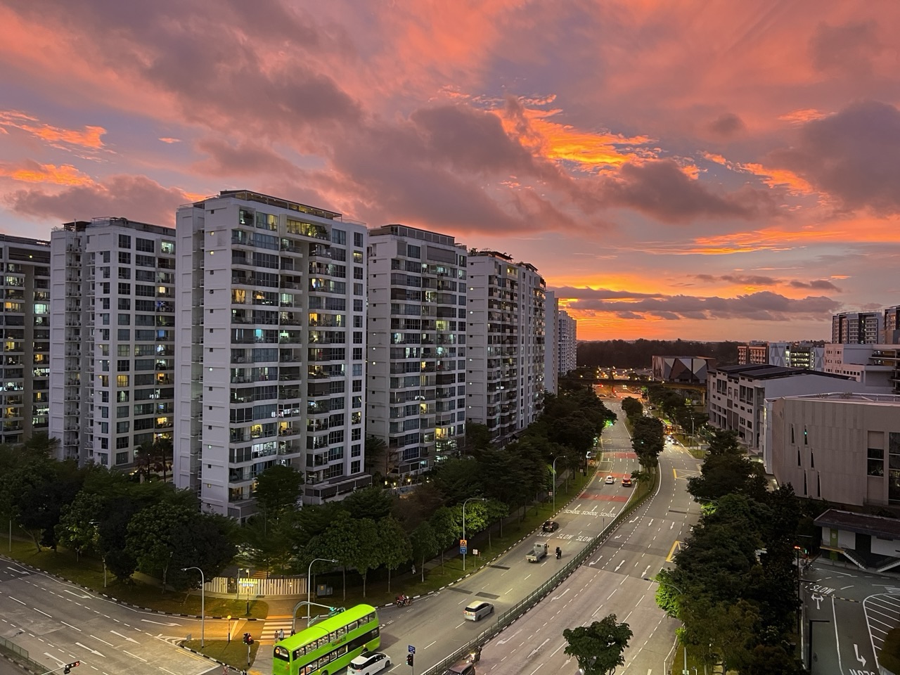
Not every Punggol sunset needs a bridge, beach or waterfront viewpoint. Sometimes the evening light falls across ordinary Punggol Central roads, condominium facades and nearby HDB blocks, turning a familiar journey home into a memorable scene. Our original October 2026 photo collection includes several images labelled Punggol Central Sunset with Condominium and Road, Sunset over Punggol Central and Punggol Central at Sunset, alongside a wider sunset and a bus-interchange image.
These photographs tell a different Punggol story from a top-ten sunset-spots itinerary. They show the **lived streetscape**: the buildings we pass, the roads we cross, and the short interval when daylight changes into evening. This photo essay looks at what the pictures genuinely show, why the light changes colour, how Punggol’s modern townscape arrived here and what a family or student can learn from a safe, thoughtful photo observation. It does not claim to measure actual haze, traffic congestion, real-estate prices or anybody’s private routine from one picture.

What these Punggol Central evening photographs capture
- Scene: Punggol Central roads and residential buildings in the light of sunset.
- Photographed subjects: condominium facades, some wider HDB/residential townscape context, the road and sky; other images show a general Punggol sunset and the bus interchange around evening.
- Place context: Punggol Central is within the modern Punggol new town developed under HDB’s waterfront-town vision.
- Why the colour changes: low-angle sunlight passes through a longer atmospheric path; shorter wavelengths scatter more strongly, leaving more orange and red light in the direct view.
- What colour alone does not prove: current air pollution, a specific PSI reading, a fire or a chemical problem.
- What a single photo cannot measure: rush-hour delays, exact housing prices, resident numbers or the duration of sunset.
- How to view safely: remain on permitted footpaths and public spaces, keep pedestrian crossings clear and avoid photographing into private homes.
- How to use the photos: a dated local record, a source-analysis example and inspiration for ordinary-neighbourhood observation—not a promise of one precise ‘best sunset time’.
For verified background, refer to HDB’s Punggol town history, National Heritage Board’s Punggol history and NASA’s explanation of low-Sun atmospheric scattering. Those sources answer historical and physical questions that a street photograph alone cannot settle.
The neighbourhood sunset that does not require a special destination
A visitor may travel to a waterfront bridge expecting the most dramatic evening view, while somebody returning from the shops notices a beautiful sky between ordinary apartment buildings. Both experiences are real. But the second is easy to overlook because the setting is familiar: road, traffic, balconies, windows and an intersection that looks mundane at midday.
Our October pictures are valuable because they document that familiar setting without manufacturing a tourism landmark. A local photo essay need not claim that every reader should travel to the exact camera position. The story is about noticing the town you already use, not convincing strangers to stand at one roadside spot at a precise time.
What we mean by ‘Punggol Central’ in this article
The media-library names identify several shots as Punggol Central with condominium and road. This gives a location context, but not an independently surveyed camera coordinate or the precise apartment block inside the frame. We should not infer the photographer’s full walking route from filenames alone. A Punggol Central label is a useful geographic description, not a complete map.
Do not use the images to guess a resident’s unit number, an exact home address or a legal place to park. If a reader wishes to explore the area, public roads and walkways should be understood through current signage and maps. The photographs exist to describe a neighbourhood mood, not to reveal personal residential details.
Punggol’s identity begins before the current towers
HDB explains that Punggol was historically a fishing village before its major transformation into a new town. The Punggol 21 blueprint was unveiled in 1996, and later Remaking Our Heartland planning introduced the waterway and broader waterfront living concepts. Today’s condominiums and HDB developments belong to a long, planned evolution rather than appearing all at once.
The images of ordinary housing gain depth against that background. A present-day skyline is a snapshot in a development story. Yet it would be careless to identify the construction year, developer or market price of a particular visible block without independent evidence. The historical account explains the town, not the ownership of individual apartments in a photograph.
What the 1996 Punggol 21 plan has to do with an ordinary road
The original ‘Waterfront Town of the 21st Century’ vision helped shape Punggol’s subsequent planning. Streets and homes are not separate from that vision; they connect residents to schools, shops, parks, transit and public services. A photo featuring road and housing is therefore relevant to understanding the town even when no water appears in the frame.
One of the easiest mistakes in writing about Punggol is to reduce the town to its waterfront attractions. Most people still spend much of their day in housing estates, crossings and transport corridors. Photographing those places alongside famous bridges creates a fuller record of what living in Punggol looks like.
Why HDB and condominium forms can appear together
Singapore’s residential new towns can contain different housing forms close to one another. HDB estates and private condominiums serve different tenure and management systems, but both rely on the surrounding public infrastructure. The photographs can show building types and their visual relationship without establishing the private lives of those who live inside.
A reader should not infer household income, nationality or social status of a specific resident from the type of building in the background. The photograph does not reveal who lives there. The built environment offers context; it is not a personal profile. This matters when teaching students to describe a neighbourhood fairly.
A warm sky changes how concrete looks
Golden or orange light can make a building’s edges look softer and alter the apparent colour of its facade. Surfaces that appear neutral in strong midday sun may look warm in the evening, while shaded sides become darker. The same tower can look noticeably different between two exposures taken only a short interval apart.
This does not mean the building has physically changed. It means the light reaching the camera and the camera’s processing have changed. A student comparing two images should account for that before claiming new paintwork or architectural alteration. Photography records light as well as objects.
Why sunset light often turns orange and red
When the Sun is low near the horizon, its light passes through a longer path in Earth’s atmosphere. Scattering removes proportionally more short-wavelength blue light from the direct beam, making the remaining direct light appear warmer. NASA’s explanation of crepuscular rays and sunset colour describes this principle.
Clouds, aerosols and camera settings can modify the final appearance. A particular photograph’s intense orange does not demonstrate that Punggol’s air was polluted that evening. Atmospheric-scattering physics explains the general mechanism; a pollution measurement requires certified air-quality data, not a glance at the sky.
Orange does not automatically mean haze
Singaporeans sometimes associate a reddish sky with haze because particles can influence light scattering. But brilliant sunsets also occur without unhealthy pollution levels. A photograph is not a calibrated atmospheric instrument, and colour differences may come from white balance, exposure or later editing.
If air quality matters to a family’s health or outdoor plans, use current NEA readings and the appropriate health guidance. It would be misleading to label a sunset image ‘dangerous haze’ purely because it looks fiery. The scientific habit is to keep observation and measurement distinct.
How a phone camera can intensify the scene
Modern phones often adjust exposure, white balance, contrast and local tone to make a scene easier to view. Those algorithms can render a sunset differently from the way a person remembers it. Even two shots taken from the same place can vary as the phone changes how it meters a bright sky and dark buildings.
That doesn’t make all phone photography unreliable. It means the image is a representation processed by a device, not a neutral scientific sample of actual light intensity. A family can enjoy the result while remaining careful about factual claims drawn from the colours.
Why foreground roads help tell the story
In a composition with a dramatic sky, a road in the foreground can anchor the image to everyday life. It adds a sense of movement, scale and transition between residential buildings. Cars may be visible, but the photograph cannot establish their routes or why they were stopped. A street scene becomes interesting without inventing a traffic report.
Many tourism photographs crop out roads to create a cleaner landscape. Here the road belongs in the story. It is part of how residents reach home and how the town functions. The best local archive is not always the one that hides ordinary infrastructure.
The photographed cars are not an official congestion measurement
Traffic lights naturally cause queues of vehicles to pause. A single image of several cars cannot tell us whether the junction is unusually slow across the evening or whether the vehicles will move seconds later. Proper congestion analysis would require repeated measurements of delay, speed and flow under defined conditions.
A secondary student can write ‘cars were visible on the road’ without claiming ‘Punggol always has terrible rush-hour traffic’. That is a useful example of evidence discipline. The first is observation; the second is a generalisation needing far more data.
Evening journeys happen for different reasons
Some people may be returning from work or school, others going out for dinner or travelling between errands. But the photograph does not identify individual drivers or pedestrians, their jobs or their destinations. We can discuss typical purposes of public streets without assigning a story to specific people pictured.
This is an important distinction in community photography. It is possible to write warmly about everyday urban life while leaving residents’ private routines alone. Use the street’s visible architecture and movements as the subject instead of imagining a named family behind a lit window.
A photograph cannot show how safe a crossing is
A road and pedestrian crossing may appear quiet from one angle, but the image cannot verify signal timings, traffic speed, turning restrictions or the current legal pedestrian route. Avoid recreating a camera position by standing in a carriageway or on a divider. Never ask a child to step into traffic just to match a picturesque sunset composition.
Stay on permitted footpaths and use marked crossings. If the best sky happens to be above a dangerous spot, accept a different view. The photograph’s purpose is to document the town, not make somebody take an unnecessary risk.
How to choose a safe place to enjoy evening light
Look for ordinary public walking or sitting areas with enough space to avoid blocking others. Do not enter condominium property or a private residential facility without permission. Do not climb barriers or lean out of unsafe places for a skyline shot. A public road-facing view can be attractive without requiring a privileged rooftop or restricted access.
For a family, a short stroll on an appropriate public path may be better than hunting for a dramatic angle. Plan a comfortable route home before the sky gets dark. The point is to enjoy the evening light, not compete for the most difficult viewpoint.
Why evening visibility changes quickly
Sunset is a transition, not a static coloured backdrop. As the Sun moves below the horizon, direct illumination weakens and streetlights become more important for navigation. A route that felt obvious a short while earlier may require closer attention to signs, cyclists and crossing signals.
With children, decide when to head back before the outing begins. If visibility deteriorates, put away the camera and focus on the walk. A family can always return for another photograph; it cannot assume that a road remains easy to cross because it looked bright in a photo taken earlier.
The role of streetlights and building lights
Evening images often contain both fading natural light and artificial illumination from roads or windows. That mixture can make exposure difficult. A bright lamp may appear blown out while a building facade becomes a silhouette. These visual effects tell us about the camera’s dynamic range rather than prove a lighting system is functioning properly across the whole town.
If an actual streetlight appears faulty or a walkway feels unsafe, use the appropriate municipal reporting channel. A photograph might help describe an observed issue, but don’t diagnose an electrical fault from a glowing or dark pixel alone. The site’s Punggol streetlights guide deals with those practical procedures.
Why sunsets are more than a waterfront experience
Punggol’s best-known scenic images often show the central waterway, Coney Island or coastal promenades. Those destinations are worthwhile, but they don’t represent every resident’s daily view. A street beside homes may deliver a sky that feels just as meaningful, particularly when the viewer has memories tied to the surrounding buildings.
This article intentionally avoids claiming a new top-ten viewing point. The existing Sunset Chasers guide handles destination discovery. Here the story is the ordinary neighbourhood scene, without a ranked attraction or a promised ticket.
How to frame a residential sunset without invading privacy
Keep attention on the skyline, building forms and public road. Avoid zooming into identifiable residents through apartment windows or photographing balconies to determine who is home. A silhouette of a residential tower can carry a visual story without showing a single private interior.
This principle applies even when the photographer can see into a space from a public road. Ethical community documentation asks whether the detail is necessary for the reader. A private household’s routine is not necessary to explain how evening light falls over Punggol Central.
Respecting people caught in the foreground
A passer-by may appear small against a broad sunset. If the person’s identity isn’t relevant, there’s no need to describe their age, relationship, occupation or beliefs. Cropping or selecting a wider frame can often remove identifying detail without losing the street scene.
Don’t place a camera directly in a stranger’s path or request that an unknown child pose in public for an online article. The best photographs of ordinary public life document places while respecting the people using them.
What a sunset image tells us about urban design
Buildings form a skyline because their heights and positions vary. Roads and pedestrian routes occupy the spaces between them. Evening light can make that arrangement easier to notice, particularly when edges become silhouettes. A student might identify a tower, lower building, road corridor and open sky as layers of the scene.
But a photograph does not disclose building height, occupancy, fire-safety requirements or land zoning with precision. HDB and URA planning documents are better sources for those facts. The photo helps a learner see a question; the official plan helps answer it.
The transition from older Punggol to a new town
HDB’s account of Punggol explains changes from its rural and agricultural past to the Punggol 21 plan and contemporary waterfront development. The modern residential streets captured in our images represent one recent stage. That context makes the photographs useful for local history even when nothing overtly historical is pictured.
A classroom discussion could ask what a person living here thirty years ago might recognise or find unfamiliar. Answer the factual part using historical records, not invented personal testimony. A modern photo becomes stronger historical evidence when paired with dated archival material.
A small Geography exercise: identify land uses
Ask a secondary student to label residential buildings, transport space and any visible open area in one Punggol Central picture. These are observable or reasonably identifiable categories. Then ask which facilities, such as schools or shops, might be nearby—but label those as questions requiring a map rather than assume they are just outside the frame.
The exercise encourages careful land-use analysis. A photograph can show different uses arranged in one urban scene without proving detailed zoning or ownership. A good answer distinguishes broad context from specific verifiable claims.
A Mathematics exercise with scale and perspective
Suppose two buildings appear different in height in a photograph. Without knowing their real distances from the camera, you cannot calculate their actual height ratio reliably from the image alone. Perspective makes closer objects appear larger. This is why a street-level sunset is a poor substitute for surveyed building measurements.
A student can explore the principle with a simple model: two equal-height objects at different distances appear different in angular size. The exact formula can be introduced at the appropriate level, but the central lesson is already useful—pixels are not metres unless a justified scale and viewpoint are available.
A Science exercise with scattering
Students can discuss why short-wavelength blue light is scattered more strongly by molecules in the atmosphere and why direct sunlight looks warmer near the horizon. NASA’s educational resources explain the general optical mechanism. Ask the student to describe the difference between a scientific explanation and a measured local atmospheric condition.
The sunset’s orange colour is consistent with scattering physics but is not enough to establish the concentration of aerosols that day. A real investigation would require instruments and validated data. Learning the limit of an explanation prevents attractive pictures from becoming unreliable environmental claims.
An English writing activity: a real scene, not a made-up interview
Have a child write a descriptive paragraph about a warm sky over Punggol Central. Encourage concrete observations: outlines of buildings, the direction of the road, changing brightness and patches of colour. If they include imagined footsteps, dialogue or thoughts, label the result as creative writing rather than a documentary account.
Parents can model a useful distinction: ‘The road appears beneath the buildings’ is visual evidence, while ‘Everyone was rushing home’ invents a population-wide intention. Creative writing is valuable; accurate captioning has a different responsibility.
A visual-arts exercise: silhouettes and negative space
Invite a student to trace the visible outline of buildings and then look at the shape of the sky around them. The dark residential blocks can create strong negative space at sunset. This helps explain why a familiar townscape sometimes appears more graphic in low light than it does at midday.
An artist can intentionally exaggerate colours in a painting. A documentary caption, by contrast, should not claim that the exact painted hue was measured at the site. Distinguishing artistic licence from factual description is part of learning to communicate well.
Why two photos from the same area can look unrelated
A slight change in direction can replace a warm sky with a darkened building face. A phone may also adjust exposure after the user taps a different point. Even if the photographer remains in the same general area, one image can look like a dramatic sunset and another like an ordinary urban street.
Compare our multiple Punggol Central images to see how the foreground and sky share attention differently. Do not assume the photographs form a precise minute-by-minute sequence or infer camera settings from filenames. The upload collection gives broad context, not complete capture metadata.
A family’s simple sunset routine
If somebody wants to enjoy the evening view close to home, choose a familiar legal public place and a convenient walking route. Keep the outing short if children are tired and make sure everyone knows how they will return. There is no need for a long journey to a famous bridge to appreciate the sky.
Check current weather and don’t go outdoors solely for a photograph during lightning or hazardous conditions. If clouds cover the colour, the family can still enjoy a brief walk. A small local tradition is better when it doesn’t require perfect skies or rigid expectations.
What if a parent has only ten minutes?
A ten-minute pause after an errand may be enough to notice the changing light. The parent can point out how the same familiar building looks different as the sun lowers, then continue home. That is a small lesson in observation and light without any special equipment.
Do not build the plan on an exact ‘sunset window’ unless you have checked current local astronomical times and conditions. Cloud cover and surrounding buildings can hide the Sun earlier than an official horizon time. A photo essay should inspire flexible noticing rather than guarantee a view.
The road and homecoming as a theme
One reason neighbourhood sunset photographs are engaging is that they connect large natural processes with small personal routines. The sky changes for an entire region, while individuals finish work, buy groceries or head to evening activities. The image holds those scales together: atmosphere above, public infrastructure below.
We can discuss that general theme without identifying the purpose of a specific driver in the image. The narrative is about the town as a shared environment, not a report on the people in one car. Respect for that boundary makes the reflection more credible.
What a traffic photo cannot say about home values
A condominium facade may prompt conversations about property prices or estate desirability, but the picture cannot establish a fair market valuation. Home prices depend on verified transactions, unit attributes, dates and broader conditions. Do not use an attractive sunset as evidence that the estate is ‘premium’ or that nearby flats have risen in value.
If the user needs a property comparison, HDB and URA transaction sources belong in a different article. This essay’s evidence is visual and historical. Let it remain that, instead of filling the page with invented price estimates.
Keeping the archive useful in 2036
Buildings change appearance, roads may be realigned and new structures may enter the skyline. A photograph from October 2026 can help future residents understand how a familiar stretch of town once looked. The value lies in preserving the image with a correct broad location and date context.
A future comparison should confirm viewpoints before announcing that a building was demolished or a road was widened. Different lenses and camera positions can make unchanged places look unfamiliar. Precise photo metadata and cautious captions make the collection stronger as local history.
The small truth that makes this photo series worth keeping
A city is not experienced only through its attractions. It is also experienced when a person stands near home and notices the sky over an ordinary road. Our Punggol Central photographs record that moment without needing to turn it into a commercial tour or an argument about the best place to live.
The broader Punggol archive includes school entrances, parks, bus stations and community facilities; this small sunset cluster gives that archive an evening dimension. It is a useful reminder that everyday places deserve the same care in documentation as the famous waterfront.
A final note on what to do with the pictures
Use them as an October 2026 visual reference for Punggol Central’s residential streetscape. Appreciate the light, compare the frames and discuss the town’s physical development using HDB’s history. Keep any current travel, air-quality and road-safety decisions grounded in the responsible official information.
A photograph can invite questions and stir memories without claiming to know every answer. That is enough. It makes the piece a local essay rather than another list of photo spots with invented coordinates or promises of perfect weather.


Frequently asked questions about Punggol Central at sunset
Where were the main sunset photos taken?
The original image records label multiple views as Punggol Central with condominiums, roads and sunset light. Exact camera coordinates are not verified.
Are these current photographs?
They were uploaded in October 2026. They document their photographed scenes and do not provide live road or weather conditions.
Is this a guide to the best sunset viewpoint?
No. It is a documentary photo essay about ordinary residential streets, not a ranked destination itinerary.
Why does the sky turn orange?
Low-angle sunlight travels through more atmosphere, which scatters relatively more short-wavelength blue light from the direct beam. NASA explains the mechanism.
Does an orange sky mean dangerous haze?
No. Atmospheric scattering, clouds and camera processing can all affect colour. Use official air-quality readings for health decisions.
Can I get the exact sunset time from the images?
No. Capture timestamps and astronomical conditions are not established by the image titles alone.
Can I stand at the road junction to copy the photo?
Never stand in the carriageway or obstruct crossings. Use lawful, safe public pedestrian locations.
Are all the buildings private condominiums?
The photo labels identify some condominium subjects, while wider Punggol town views include residential context. Do not identify every block or tenure without verification.
Does a condominium in a sunset photo imply a particular property price?
No. A photograph cannot establish market price, occupancy, tenure of individual units or financial status of residents.
How does this relate to Punggol’s history?
HDB describes Punggol’s transformation from a former rural area to the Punggol 21 waterfront-town plan and later developments.
Are the road images evidence of traffic congestion?
Not by themselves. Traffic delays and persistent queues require repeated measurements and context.
Can a phone alter sunset colours?
Yes. White balance, exposure, contrast and image processing can change the final appearance.
Can students use the images for English?
Yes. They can practise precise description while distinguishing observation from imagination.
Can students use them for Science?
Yes. They provide an accessible starting point for a lesson on light scattering and the limits of evidence.
Are the photographs suitable for Geography?
They can support discussion of land use, residential form and transport space, but not detailed zoning claims without official sources.
Can I photograph people through their windows?
Avoid intrusive images of private interiors or identifiable residents. The article focuses on public streetscape and building form.
Does this photo set include the Punggol Waterway?
The main cluster is about Punggol Central residential streets, not a systematic record of the waterway’s bridges or trails.
Are sunset and sunrise photos the same event?
No. The archive contains both types; they should be labelled separately and not stitched into an invented chronology.
Where can I find a guide to waterfront sunset spots?
Use the separate Punggol Sunset Chasers and Waterway Park articles linked below.
Can a single photo prove a road or building has changed?
Only with a verified older comparison from a matching viewpoint and supporting records. Perspective alone can mislead.
Why publish ordinary streets instead of a landmark?
Because everyday transport and housing are central to what Punggol residents experience and worth documenting accurately.
Primary sources and onward photo guides
- HDB — Punggol town history, Punggol 21 and eco-town planning.
- National Heritage Board — History of Punggol.
- NASA — Crepuscular Rays and Light Scattering.
- NASA — Visible Light Scattering.
- Punggol Sunset Chasers — location recommendations.
- Punggol Photo Essay Walk — compose your own images.
- Punggol Streetlights and Safer Evening Walking.
- Punggol in Pictures — wider October 2026 local archive.
- Complete Punggol Guide
Image and editorial note: reviewed 23 October 2026. The article uses original October 2026 eduKatePunggol photograph records. The primary views are labelled Punggol Central; wider sunset, interchange and sunrise images are clearly distinguished. Photo colours are not treated as measured air quality, and no individual’s residence, identity or private routine is inferred.


