
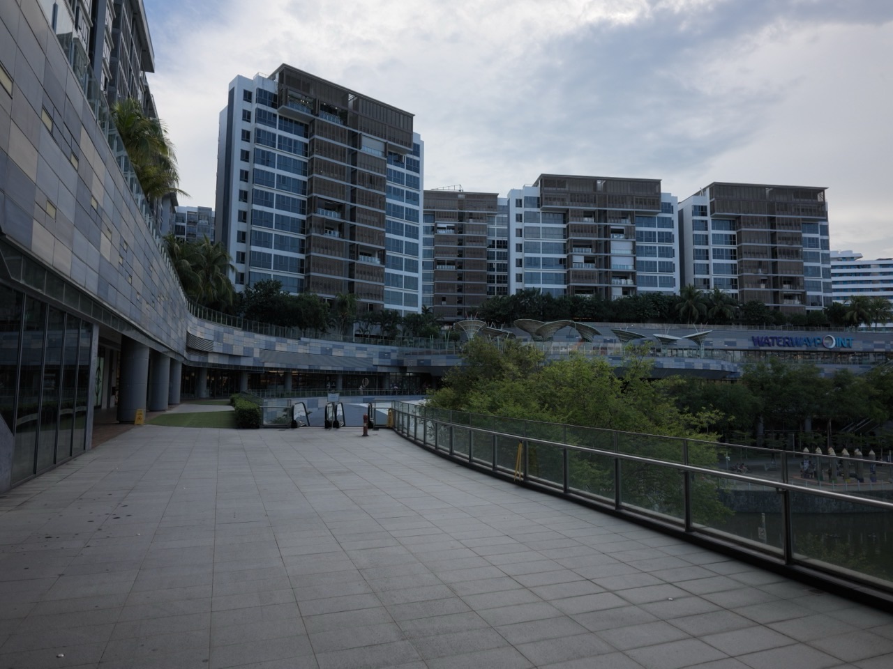
Waterway Point has another side that shoppers sometimes miss: the outdoor connection between its terraces, Watertown residences and the landscaped Punggol Waterway. Our original October 2026 photographs include an outdoor escalator between Waterway Point and Watertown, the mall’s exterior facade, outdoor shopfronts, the waterside walking path, resting areas and a separate building service frontage. Together, these images explain why Waterway Point is more than an enclosed shopping centre beside Punggol MRT.
This guide isn’t a map of secret exits, a list of Waterway Point’s East and West Wing shops or a general Punggol park itinerary. It looks specifically at the public-facing waterfront edge: how a mixed-use development meets a pedestrian corridor, why the landscape is pleasant but also contains operational infrastructure, and how families can make a short, considerate visit without assuming every visible staircase, private residential route or service area is open to them.

Waterway Point’s waterfront side: the essentials
- Main destination: Waterway Point, 83 Punggol Central, Singapore 828761, beside Punggol MRT/LRT.
- Development: the mall forms the retail component of the mixed-use Watertown waterfront residential and retail project.
- Historical project description: Frasers Property identifies Watertown as a 992-residence integrated development with waterfront dining and retail; the site’s exact tenant mix changes over time.
- Design connection: RSP describes pedestrian connections between the project and transport, along with terraced public-facing spaces complementing the waterway.
- Photographed October 2026: outdoor escalators, rear-facing shopfronts, public path views, residential buildings and separate service infrastructure.
- What needs an on-site check: escalator operation, current pedestrian routes, step-free options, opening times of specific shops and any temporary closure.
- What a photo cannot authorise: entry into private Watertown residential areas, staff operations, delivery routes, plant rooms or restricted service spaces.
- For the park: NParks manages Punggol Waterway Park, with visitor rules and park information separate from mall management.
- For a family: choose a short public path, observe signs, plan how to return, and respect other walkers and riders.
The key sources are Frasers Property’s Watertown development page, RSP’s project design explanation, the official Waterway Point visitor page and NParks’ Punggol Waterway Park information. Older project figures describe design intent or historical completion and should not be turned into present-day shop, access or leasing guarantees.
Why the side facing the water feels different from the front facing the station
A visitor arriving from Punggol MRT may first experience Waterway Point as a transport-connected shopping destination. Turn toward the waterway, and the impression changes. You see outdoor terraces, paths, vegetation, the mall’s built edge and nearby residential forms. The activity becomes less about finding a particular shop and more about the relationship between a building and the public landscape around it.
That shift matters. It shows why urban designers talk about the interface between private developments and public spaces. A mall isn’t experienced only through its floor directory. The entrances, walkways and spaces around it influence whether residents can pass through, pause or connect their errands with time outdoors. The photograph introduces that relationship without proving every route is open.
Waterway Point and Watertown are connected but not identical
Frasers Property describes Waterway Point as part of the Watertown integrated residential and retail development. Watertown is the residential component, with 992 units in the developer’s historical project information. The mall’s shops and the residences share a broader development setting but have different property and access arrangements.
A shopper cannot assume an attractive staircase or lift leading toward the residences is public. Read the current signs and use designated areas. An image showing a connection should not be captioned as a universal shortcut to someone’s home. Respecting the separation between public retail and private residential space is part of enjoying the shared waterfront respectfully.
What the architect says about the development
RSP’s project description explains a design that extends the waterfront experience through terraces and pedestrian connections linking Watertown, Waterway Point and transport. It describes multiple outdoor levels and public-facing spaces in a project intended to make the waterfront part of ordinary community life.
That official design explanation is more useful than guessing an architectural intention from a single photograph. The images show selected external features; the design source explains why those types of features were included. A student can combine them to understand the project, provided they distinguish a design statement from a guarantee that a particular facility is operating today.
The outdoor escalator in the image
Our first October photograph is labelled ‘Outdoor escalator between Waterway Point and Watertown’. It shows an element of vertical movement, which helps explain why the development feels terraced rather than flat. Vertical changes matter when a site has retail, waterway paths and residential levels occupying different heights.
The image does not establish whether the escalator runs continuously, which direction it operates today, who is permitted to use it or whether nearby lifts are working. For real access, the official building signs and staff instructions govern. A parent with a stroller should never substitute an escalator photograph for a verified suitable route.
A second escalator image can tell a different story
The same October upload contains another outdoor escalator view with a person in the frame. A different viewpoint can alter how steep, long or central the structure appears. It also changes the viewer’s sense of the adjacent building and outdoor circulation.
Do not describe the person as a resident, worker or delivery rider unless the source actually establishes that identity and publication is appropriate. The point of the photograph is the publicly visible structure. A wide contextual caption is more useful than inventing a personal story about somebody passing through it.
What ‘terraced’ means in everyday language
A terraced building arrangement uses changes in level to create distinct platforms and relationships between spaces. Instead of forcing all activities onto one flat plane, the development can place retail, pedestrian routes and landscaped spaces at different elevations. RSP discusses the role of stepped terraces in Watertown’s design.
This isn’t permission to climb onto every visible terrace. Public-facing open areas may coexist with private property and restricted facilities. A family should treat a level change as a navigation question: where does the permitted path continue, and what is the appropriate accessible route? The answer comes from current signs, not architectural admiration.
Why Punggol’s waterway is next to a large shopping complex
HDB’s Punggol town history explains that the 4.2 km man-made waterway was part of the Punggol 21 and Remaking Our Heartland vision for waterfront living. Waterway Point and Watertown are examples of how shopping and housing were integrated into that broader landscape. Their proximity to water is deliberate town development, not merely an incidental view from a mall.
The public waterway also has its own park and shared-path functions. That means visitors can encounter shopping areas, residential buildings and park users within a short geographical span. But the rules of a retail mall, condominium and NParks park are not identical. Accurate wayfinding respects those boundaries.
The waterway path has a different purpose from an indoor mall corridor
Inside a mall, visitors may be heading for a shop or restaurant. Along a park-side path, people may be walking, jogging, cycling through or simply taking a short break. Movement speeds, surfaces and the need to share space can differ. Our waterway-path photographs illustrate that public recreational corridor.
Do not treat a park path as a private mall queue. Stay to the appropriate side where markings require it, keep groups from blocking the full width and look before moving into a rider’s path. Conversely, riders should slow and observe current active-mobility rules around other users. The shared environment works when everyone recognises that other people have legitimate reasons to be there.
How to reach the water without inventing an exact secret route
Waterway Point’s official visitor page gives its permanent address and transport connection, while NParks identifies the separate park and waterway. A person wanting a short stroll can use current mall and park signs to find a designated public approach. The photograph collection proves the waterfront setting exists, not the exact position of every safe crossing, lift or accessible entrance.
We deliberately do not publish instructions such as ‘go through the service lane and down the unmarked steps’. A photograph’s shortest visual line may not be a legal public path. Follow signed routes or ask the mall’s concierge for present access information. A little extra walking is preferable to entering the wrong space.
Why the outdoor shops are part of the experience
One of the photo records is labelled ‘Outdoor shopfronts at the rear of Waterway Point’. Shops that face a promenade can change the feel of a public path. A family may move between errands and outdoor views without the entire experience taking place in a sealed indoor corridor.
Storefront photos are dated. They do not guarantee a particular business remains open or that its outdoor seating may be used freely by every passer-by. The mall’s current directory and the businesses themselves own that information. The architectural point is the mixture of indoor retail, external frontage and public circulation.
Outdoor seating is a comfort feature, not an entitlement to a particular table
Waterway-side seating appears in the October photo set. It is easy to imagine a parent stopping for a drink while a child takes a break from shopping. But we cannot know from the picture whether a given seat belongs to a restaurant, is general public seating or has specific use restrictions.
Check the current signs and respect businesses’ seating arrangements. Don’t assume every attractive chair beside a waterfront is a free picnic area. If the family needs a rest, identify a legitimate public seat and avoid blocking the path. The convenience comes from planning a comfortable stop, not claiming the first empty chair in view.
The resting corner can change a family’s whole visit
A large shopping trip can be tiring for a toddler, grandparent or somebody carrying bags. A short permitted pause beside greenery may improve the experience without adding another activity. The photographed resting area suggests how a mall and park can complement one another.
However, the availability of a particular bench is not guaranteed. Consider whether the group can comfortably walk back if the seat is occupied. A family can choose to return indoors or shorten the outing. The point is flexibility, not a promise of a picturesque private space every time.
A service frontage has a legitimate job
Some images show a rear service area and visible air-conditioning-related equipment. Large buildings require infrastructure for deliveries, maintenance, waste management and environmental control. The existence of operational infrastructure beside a pleasant landscaped route is not a contradiction; it is part of what allows retail and residential buildings to function.
Visitors should stay in public areas and avoid treating staff entrances or equipment zones as walking shortcuts or sightseeing attractions. Our descriptions remain broad: the photograph documents a visible service frontage, not access-control details or a route through restricted areas. Good local publishing respects operational safety.
Why an air-conditioning plant photograph is not an energy audit
A photograph may show external equipment, but it does not establish its power consumption, efficiency, carbon emissions or operating state. You cannot infer annual electricity use from the apparent number or size of units in a partial frame. The relevant evidence would include technical specifications, metered data and building-management information.
A student interested in sustainable design can ask good questions from the image—how buildings manage heat, why equipment needs ventilation and how shared services affect the waterfront—but should not supply invented numerical results. Frasers’ project descriptions and Singapore’s building standards offer context, not a photo-based measurement of this one component.
The difference between the public waterfront and private home amenities
Watertown has residential amenities that may appear in developer marketing, and the mall has publicly accessible retail areas. Being part of the same integrated development does not make a condominium swimming pool, terrace or garden freely accessible to mall shoppers.
Never advise readers to tailgate through a residential door to improve a waterway view. Likewise, avoid photographing into private units from nearby public spaces. The boundary between access and privacy is not always obvious in a photograph; follow present signage and approved routes.
Why the waterfront scene includes roads and service access
A complex that supports shopping and residences must accommodate deliveries, waste handling, maintenance and transport as well as pleasant walking routes. A photograph showing a delivery-side corridor does not mean the public can use it, nor does an attractive canal guarantee that service operations are invisible.
Understanding the whole place makes the architectural story more interesting. Public space and infrastructure coexist, with different areas intended for different users. We can appreciate the design without criticising essential work simply because equipment appears in a picturesque photograph.
A short walk is usually better than an ambitious route
If a family is shopping and wants a breath of outdoor air, it may be enough to step onto a permitted waterfront path, enjoy a brief view and return. There is no need to complete all of Punggol Waterway Park’s four themed zones in one outing.
Before leaving the mall, know how you will return and whether you are taking a stroller, heavy shopping bags or an older relative. The most useful walking plan fits the people present. Avoid turning a short break into a long, tiring circuit because a map makes the canal look beautifully continuous.
Where the waterway park belongs in this story
NParks lists Punggol Waterway Park along Sentul Crescent, with themed areas such as Nature Cove, Recreation Zone, Heritage Zone and Green Gallery. Those zones provide the larger park context, but this article concentrates on the mall’s outward-facing edge and the nearby canal pictures.
For a fuller park visit, use the dedicated Punggol Waterway Park Guide. The waterfront mall connection is only one way to encounter the park setting. It should not be presented as the only entrance or the only appropriate starting point.
This is not Punggol Promenade Riverside Walk at Tebing Lane
One source of confusion is the word ‘riverside’. Punggol Promenade Riverside Walk is a separate NParks park-connector section near Tebing Lane and Serangoon Reservoir. The canal shown immediately beside Waterway Point belongs to the central Punggol Waterway environment.
A reader planning a route must use the precise location name. The site’s two-waterfronts comparison explains that geography. Here we are discussing the mall’s relationship with the central waterway, not providing access instructions to Tebing Lane.
How the waterfront shops and mall levels fit together
Waterway Point is arranged in different wings and levels, with public retail routes that connect to the surrounding town. An attractive outdoor escalator photograph may give a sense of vertical circulation without showing the complete directory. Indoor shopping routes and outdoor waterfront paths are complementary but not interchangeable.
Readers who need a specific East or West Wing floor should use the existing Waterway Point wing-navigation guide and current mall signs. This article focuses on the exterior landscape and terraces, not today’s location of every shop.
A first visit with small children
Children may enjoy the view of water and bridges, but a waterfront path introduces safety considerations. Stay within permitted public space, supervise young children near railings and discourage climbing for photographs. Keep a comfortable distance from riders and other walkers. If the child is tired after shopping, shorten the outing.
It helps to explain the plan simply: ‘We will go outside for a short look and then return to the mall.’ The promise is manageable and does not depend on a particular outdoor attraction running. A small, predictable break can be more enjoyable than a long spontaneous detour.
A first visit with a stroller
A stroller makes the choice of lifts, ramps and permitted paths especially important. A photographed escalator does not confirm a safe stroller route or the availability of a functioning lift. Follow the mall’s current accessible wayfinding and check conditions before leaving a level.
Do not carry a child in an unsafe way merely to use an impressive architectural feature. A family may decide the accessible route is too inconvenient that day and return to an indoor activity. That is a sensible choice, not a failure to enjoy the waterfront.
A first visit with an older relative
Some older visitors enjoy gentle waterside views, while others prefer not to negotiate steps or outdoor heat. Ask what the person actually wants and which distances are comfortable. A resting area may be valuable, but no specific seat can be reserved through a photograph.
Start with a short public route and allow an easy return. Don’t assume that someone wants assistance or that every person of the same age has the same mobility needs. The success of an integrated development depends partly on how flexibly people can choose their own level of participation.
Why outdoor escalators invite interesting architectural photographs
Stairs and escalators create strong lines, diagonal movement and contrasts between levels. In a composition with Watertown above and Waterway Point below, the eye naturally follows these elements across the frame. The photographer can tell a story about connection even without a person in the centre of the image.
That visual quality can tempt someone to stand at a dangerous angle for symmetry. Don’t do it. Never block an operating escalator or stop at its landing to compose a photograph. A less dramatic image taken safely is better than obstructing other users.
How to photograph a public waterway without blocking the path
Choose a safe permitted position beside the path and keep enough room for walkers and riders to pass. Avoid stopping abruptly or placing a tripod across a shared route. Frame water, vegetation and architecture while respecting people using the space.
A photograph does not have to identify every stranger to convey life around the canal. A wide viewpoint often captures more of the relationship between buildings and water while avoiding intrusive details. This is a useful standard for community publishers and family photographers alike.
Why the canal can look different in each photo
Water reflections vary with light, cloud, angle and movement. A shallow-looking photograph does not reveal water depth or current. A dark surface does not automatically mean pollution; exposure and surroundings can alter appearance. Similarly, a sunny photograph cannot establish safe swimming conditions.
Students can practise describing water appearance accurately and then asking which scientific measurements would be needed for a claim about quality or flow. The answer is not found by zooming in on a screenshot. Good photography and good scientific reasoning ask different things of the same scene.
The role of greenery beside large buildings
The landscaping seen near Waterway Point softens the visual edge between hard surfaces and the waterway. Plants can contribute shade and habitat, though their actual environmental effects depend on species, design and maintenance. A photograph of green leaves alone cannot quantify cooling, air purification or biodiversity.
An interesting student question is how different materials—concrete, planted areas, water and glass—interact in a dense townscape. The image offers a starting point. To measure real effects, you need defined methods and data. That distinction prevents generic ‘green building’ claims from outrunning the evidence.
Why a bridge can matter even when it is not the main attraction
Bridges along the Punggol Waterway join paths and shape the way people experience the canal. From a mall-side photo, a bridge may simply appear as a distant compositional feature. For a pedestrian, it can be part of a real route, but the appropriate direction and crossing rules require an actual map.
Our collection includes many Waterway Park bridge views. This article uses them to explain the waterside setting, not to identify every named bridge from a distant photograph. The site’s Bridge-Hunting Walk is better suited to the full landmark activity.
The mall and park have different authorities
Waterway Point’s retail and concierge arrangements are managed through its mall operator, while NParks supplies information and rules for the park. Residential property arrangements belong to the relevant private management. Even when a person can walk between areas, the responsible authority changes with the space.
This matters for questions about lost items, repairs, seating, accessibility or events. A shop’s closing hour is not the park’s operating hour. A park notice does not grant access to a condominium pool. Understanding who manages what makes a destination easier to use responsibly.
What to do if an escalator or route is temporarily closed
A mechanical route can be unavailable for maintenance or operational reasons. Never step past a barrier or use a restricted access route simply because an older photograph shows it open. Look for a signed alternative and ask the mall staff about a suitable current path.
If somebody needs a step-free option, do not simply recommend another escalator. Ask which accessible route is available. That detail can determine whether the outdoor break is practical for the person. A photo guide should tell readers how to verify, not pretend to maintain a live equipment status feed.
The rainy-day version of the waterfront
Outdoor areas beside a mall are not automatically fully sheltered. Rain may make steps or surfaces slippery, and wind can blow water into open terraces. If there is lightning, a proper safe indoor shelter is more important than a quick photograph from near the canal.
A family can stay inside Waterway Point if conditions are poor and return outside on another day. Punggol’s waterway is a permanent landscape; there is no reason to rush an unsafe visit simply because the mall offers convenient access.
The hot-afternoon version
Heat and humidity can make a pleasant-looking outdoor path uncomfortable, especially for younger children and older visitors. Sun protection, drinking water and a short return option are useful. A roof casting shade in a photograph does not establish that a path is cool at every hour.
Let people set their own pace. If somebody wants to sit indoors instead, that can still be part of a successful day at an integrated mall. The built environment offers options rather than a single correct itinerary.
A small Geography lesson about mixed land use
Place three labels on a copy of the photograph: ‘retail’, ‘residential’ and ‘waterfront public environment’. The relationship among them explains why integrated developments are often discussed as more than buildings. People may live, shop and walk in neighbouring spaces without taking a long trip across town.
A student can ask what benefits and tensions might arise when different users share the same area. The photograph does not establish actual residents’ opinions, so those remain questions to research. The lesson is in identifying visible functions and appropriate sources, not inventing a survey result.
A Design & Technology lesson about level changes
An older student may notice that pedestrian movement between different levels requires decisions about stairs, escalators, ramps and lifts. Each has different design and maintenance implications. The photographed escalator is one part of that system, not the whole system.
Ask the student which information would be needed to assess accessibility: gradients, lift availability, signage, clearances and current route conditions. The exercise shows why a design can’t be evaluated simply by its attractive photograph. The most important user may be the one who cannot use the most visually prominent route.
A Mathematics lesson on routes and time
Suppose, hypothetically, a family wants to walk 300 metres to a viewpoint and 300 metres back. At an illustrative pace of 1 metre per second, walking alone would take 600 seconds, or ten minutes, before accounting for pauses, lift waits or crossings. Those figures are a worked example, not measurements of the actual Waterway Point path.
The useful insight is that time estimates depend on the person and route, not merely on a map’s straight-line distance. Older children can add reasonable allowances and compare scenarios. They should label assumptions clearly rather than invent a precise official walking time from the mall to a photographed bench.
A Science question about heat from buildings
Glass, concrete, vegetation and water respond differently to sunlight and heat. That makes a built waterfront a rich starting point for questions about urban climate. Yet a photograph of exposed equipment or reflective windows cannot establish a building’s precise temperature or energy demand.
A fair inquiry would define measurement points, instruments and times before drawing conclusions. Asking whether trees or shade improve comfort is sensible; declaring a particular temperature reduction without data is not. This distinction is useful far beyond Waterway Point.
A writing exercise about public and private space
Ask a secondary student to describe the outdoor escalator image without making false assumptions about access. A good paragraph might say, ‘An escalator connects visible levels in the mixed-use development, while nearby buildings and terraces frame the route.’ A poor paragraph might declare that the escalator leads directly to a private resident’s door and is always open.
The point is precise, ethical language. Local guides are widely read, and one mistaken sentence about access can send real visitors into inappropriate areas. Writers can be descriptive and conversational while keeping claims tied to evidence.
A practical thirty-minute family plan
If your family is already at Waterway Point, choose one small public-facing waterfront observation rather than attempt a grand tour. Check current signs for an appropriate exit, walk a comfortable distance, pause at a legitimate public place and return through a verified path. Keep children supervised, and don’t promise a vacant bench or open shop.
The thirty minutes is an example of a self-chosen outing length, not a measured route duration or guaranteed park programme. A family can shorten the plan if weather, accessibility or energy makes that sensible. The important outcome is a comfortable change of scene beside the water.
Why this is not a substitute for the mall’s wing directory
A reader trying to find a specific tenant needs the correct East or West Wing, level and live directory. The outdoor photos do not provide that. The site already has a Waterway Point East versus West Wing photo guide for that search intent.
This article owns a different question: how does the development’s public-facing outdoor edge connect shopping, residential form and park landscape? Keeping those purposes separate reduces duplicate content and helps visitors select the right source for the task.
What the rear service photos should never become
A wide photograph of building equipment can help explain that malls need operations behind the attractive storefronts. It should not be turned into detailed instructions for locating staff-only entrances, bypassing barriers or accessing private service rooms. The images belong to an urban-design discussion, not an access plan.
Residents, workers and mall visitors all benefit when operational boundaries are respected. Describe the visible equipment in general terms and let facility management own security and access arrangements. Good local storytelling doesn’t require revealing restricted paths.
How the October photo set will help future readers
Photographs of external facades, terraces and pedestrian spaces can become valuable records if buildings or landscaping change. A later resident may compare the public-facing skyline with a dated October 2026 view. That is useful only if the original caption records what it actually shows and avoids claiming today’s conditions will last forever.
Don’t treat the media upload order as a measured walking route. Different cameras and angles can produce images that seem sequential but were not. A long-term archive becomes stronger when it keeps place labels, photographer metadata and operational statements separate.
A final first-time visitor checklist
Start with the official Waterway Point address and your actual destination inside the mall. If you want a short waterfront break, follow current public signs and check accessible routes where needed. Treat visible terraces and outdoor escalators as architectural context until you’ve confirmed they are open for the intended journey. Stay out of private residential and staff areas.
On the path, respect other users, supervise children and plan how to return. When weather or a closure changes things, return indoors or try another day. The photographs can make the waterfront edge feel familiar, but the current place—not an article—sets the operational rules.


Frequently asked questions about Waterway Point’s waterfront edge
Is Waterway Point connected to Watertown?
Yes. Frasers Property identifies Waterway Point as the retail part of its mixed-use Watertown waterfront residential development.
Where is Waterway Point?
83 Punggol Central, Singapore 828761, beside Punggol MRT/LRT.
What are the escalators in these photos?
The media-library captions identify outdoor escalators between Waterway Point and Watertown. Current operation and permitted access must be checked on site.
Can anyone use the private residential areas?
No public-access assumption should be made. Follow building rules and do not enter Watertown’s restricted residential amenities without authorisation.
Is the Punggol Waterway visible from near the mall?
The original October 2026 images document canal-side paths, landscape and the retail building within the central Punggol setting.
Does the mall have outdoor-facing shops?
The photo set documents external shopfronts. Current business identities, hours and rules require the mall directory and establishment information.
Where should I go for a short waterfront walk?
Use present mall and NParks signs to reach a designated public path. This article does not claim a secret shortcut or precise walking time.
Is the outdoor escalator wheelchair-accessible?
An escalator is not the same as a verified step-free route. Check current lift and ramp options suitable for the visitor.
Can I take a stroller on any visible staircase?
Choose a safe permitted route and do not assume every staircase or escalator is suitable for a stroller.
Are all waterfront benches public?
Not necessarily. Some outdoor seats may belong to businesses. Follow present signs and staff directions.
May I use a service area as a shortcut?
No. Stay within authorised public routes and keep clear of staff operations and delivery areas.
Is Watertown a condominium?
It is the project’s residential component; Frasers’ historical description lists 992 units.
Why is the mall built near the waterway?
Punggol’s waterfront-town planning encouraged integrated residential, retail and recreational development along the man-made waterway.
Is this the same as Punggol Promenade Riverside Walk?
No. Punggol Promenade Riverside Walk is a separate section near Tebing Lane and Serangoon Reservoir.
Does a photo of air-conditioning equipment show energy use?
No. Energy performance needs metered data and technical specifications rather than an exterior photograph.
Can I photograph the outside of the mall?
Use lawful and safe public positions, follow venue rules and respect other people’s privacy.
Are waterside paths open all the time?
Do not assume a particular connector, escalator or mall door is continuously available. Current operational signs take priority.
Which organisation runs the mall?
Frasers Property provides the official Waterway Point website and visitor information.
Who provides official information about the park?
NParks publishes Punggol Waterway Park’s facilities, rules and general park information.
Does this page replace the East/West Wing guide?
No. The wing guide serves interior store navigation; this page explains the public-facing outdoor waterfront side.
Why show the service frontage at all?
It illustrates the infrastructure that supports mixed-use buildings without publishing restricted-access instructions or engineering claims.
Primary sources and next useful Punggol routes
- Frasers Property — Waterway Point & Punggol Watertown.
- RSP — Watertown & Waterway Point project design.
- Frasers Centrepoint Trust — Waterway Point portfolio and connectivity.
- Waterway Point — official visitor address and current services.
- NParks — Punggol Waterway Park and public rules.
- HDB — Punggol town and waterfront development history.
- Waterway Point East versus West Wing — indoor navigation.
- Punggol Waterway Park Guide — the wider park.
- Punggol Riverside versus Waterway Park — geography clarification.
- Complete Punggol Guide
Editorial note, 23 October 2026: original October 2026 photographs are drawn from the eduKatePunggol media archive. Frasers Property and RSP supply the historical mixed-use development and design context; NParks supplies the park context. Photography does not confirm today’s escalator operation, private access, shop tenancy, route accessibility or equipment energy use. Follow current signs and the responsible facility management.


