
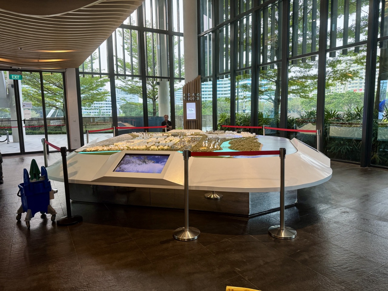
The Punggol Discovery Cube at Punggol Town Square is a visitor centre built to explain Punggol’s development, history and plans. Its miniature town model is a wonderful way to ask a surprisingly powerful question: how does the neighbourhood actually fit together? Our newly uploaded October 2026 photographs show the model inside the Cube, giving families, curious residents and students a real object to discuss rather than another generic illustration of Singapore urban planning.
Start with the answer. The Cube opened with Punggol Town Square on 15 January 2017 and was identified by HDB as the first visitor centre in an HDB town. A model like this can help you see relationships among homes, waterways, transport and public places. It is not a live navigation map, proof that a future building is open or a substitute for a current official planning document. The most useful visit is one where you leave knowing what you observed, what you inferred and what you still need to check.

Punggol Discovery Cube: the quick facts
- What: an interpretive visitor centre at Punggol Town Square, associated with the model and displays about the town’s history and development.
- When it opened: 15 January 2017, according to the Prime Minister’s Office’s opening speech.
- Why it matters: HDB identifies it as the first visitor centre in an HDB town; it helps residents understand the town around them.
- What our latest images show: the miniature town model, photographed in October 2026.
- What remains unverified here: today’s admission arrangements, exact opening hours, working interactive exhibits, accessibility details and whether any particular display has changed.
- Good visitor question: which parts of Punggol do we recognise, and how could we check the rest against an up-to-date official map?
HDB’s Town and Community Plazas page places the Cube at Punggol Town Square beside the wider Punggol town-centre setting. The 15 January 2017 opening speech explains its intended role in telling the town’s history and showing sustainability ideas. Those historical statements do not give a live 2026 visitor timetable. Check current entrance notices before making a special journey solely for the exhibition.
Why a miniature town can explain more than a big map
When we stand on Punggol’s streets, we experience the neighbourhood one path at a time. A child sees the crossing outside school; a grandparent thinks about the closest sheltered route; a student thinks about how to reach the library; a delivery worker needs building access. The model lets us lift our eyes above any one journey. It shows that an HDB town is not just a collection of blocks but a set of decisions about what should be near, connected, separated or protected.
That shift from street-level experience to a bird’s-eye view is the real attraction. Instead of simply announcing that Punggol has housing, water, greenery and transport, try showing how these parts fit. A home is more useful when residents have a reasonable way to reach everyday services. A park is better used when there are ways to enter and leave. A railway can be a remarkable connector, but its viaduct and stations also shape the ground-level spaces around it.
A model allows a family to hold these relationships in one view. It also reveals limitations. The actual feeling of noise, shade, crowding, heat and road-crossing difficulty is hard to encode in a miniature. An excellent conversation takes both views seriously: what the model helps us see, and what living in the neighbourhood tells us that the model cannot.
The first task: find a landmark you know
Don’t start by identifying every building. Give each person one familiar anchor. It might be Punggol MRT, Waterway Point, a visible part of the waterway or a building they recognise from the neighbourhood. Ask them to point out a second related place. Can they trace the connection between the two? If not, that’s interesting: perhaps the model’s scale or orientation is different from the mental map they carry.
For children, this is a valuable explanation of scale. A building that feels huge at street level becomes a small block in the model. A very long walk may look only a finger’s breadth. Without a verified scale printed on the specific model, you cannot measure that breadth and declare it represents a fixed distance. The correct learning question is ‘What information would we need before measuring?’ rather than ‘Can we guess the distance from this picture?’
The second task: water first, because Punggol has a waterway story
Punggol is often described through its waterfront identity. The HDB-era planning story is about more than a picturesque blue strip. Water shapes the way people move, where bridges are built, how walking routes meet and where public open space can have value. The model can serve as a visual prompt: which neighbourhoods are separated by the water, and which crossings link them? Does a bridge connect useful places, or is it a striking photograph without an obvious route?
With an older child, add a caution about sources. A three-dimensional model might show a waterway’s shape, but not water-quality readings, ecological health or flood-design capacity. Don’t infer those from attractive colours. Use official HDB, NParks or PUB information if the discussion moves into those specific technical questions. The model creates good questions; a responsible student learns where to obtain the evidence to answer them.

The third task: how do MRT and LRT connections change the town?
Rail transport is easier to understand in context than as a list of station names. Punggol MRT connects into the North East Line, while the Punggol LRT loops provide local links. On a town model, ask what a resident gains when public transport connects homes to jobs, schools, shops, open space and community facilities. Does a connection make a journey straightforward, or does it require a transfer? The answer depends on the actual current network, not simply on how close two model buildings appear.
This matters for parents, because children eventually begin making more independent journeys. A map exercise can teach that knowing a station name is not the same as knowing a safe route. Crossing points, station entrances, current platform signs and service notices matter. Our Punggol transport guide covers practical system details. The Cube exercise is about seeing the network as a whole and asking better questions.
The fourth task: distinguish homes from public spaces
Look at how residential clusters sit near parks, roads and activity nodes. A dense cluster of buildings may suggest a place where many people live, but a model cannot show exactly how lively or quiet an individual block is in the evening. Similarly, a blank or green-looking patch cannot by itself establish that the public may enter it at any hour. Land-use colours, development phases and public access can carry different meanings.
Ask a practical question: ‘Where can somebody be without paying to be there?’ This might lead to a comparison among a town square, a mall, a playground and a community space. A shopping centre welcomes the public within its own management rules, but a town square has a different civic purpose. A visitor centre explains the place. An LRT station moves people through it. The relationships between these places make the centre interesting, not their names alone.
Reading the town by layers rather than all at once
One effective way to prevent visual overload is to consider one layer per minute. First, look for the waterway and major open spaces. Second, consider rail corridors and streets. Third, locate residential zones. Fourth, choose key community services. Only then combine them: imagine a journey from a home to a school, then to a library, then back to transit. You will begin to notice why the location of each layer matters to the others.
Layering is also a useful research method. In Geography, people ask about land use, human movement and environmental impact. In Mathematics, they ask about relative position, proportion and scale. In Social Studies, they ask who benefits from access and whether different people have different needs. The same Punggol model can support these questions without pretending that they are the same subject or that every conclusion is automatically correct.
What a model can prove — and what it cannot
- Can support: a visual comparison of the model’s represented buildings, waterways, paths and broad relationships.
- Cannot alone prove: that every represented development has been completed, occupied or opened to the public.
- Can prompt: a discussion of how housing, jobs, transport and leisure facilities relate.
- Cannot alone measure: actual walking times, gradients, crowding, accessibility or traffic conditions.
- Can reveal: what designers chose to show at the time the model was prepared.
- Cannot automatically validate: current policy, zoning, service frequency, school catchments or future completion schedules.
- Best next step: confirm any date-sensitive claim on the relevant agency’s current source.
Many impressive displays are designed to make a complex project legible to the public. Their usefulness does not remove the obligation to read dates and legends. ‘Proposed’, ‘illustrative’, ‘subject to change’ and ‘open’ are different claims. A child who learns to spot those words gains a habit they can use far beyond Punggol, including when reading property advertisements, news visualisations and social-media maps.
Punggol before and after: why the 2017 date matters
The Cube opened in January 2017, during a major period of Punggol’s transformation. An opening speech from that year is a valuable historical source, but it belongs to its year. Statements about future developments in that speech describe what was planned or anticipated in 2017. They should not be reproduced as an unqualified present-tense account in 2026. Families can make a two-column comparison: ‘What the historical source said’ and ‘What today’s official information confirms’.
This small habit prevents an otherwise common mistake. A 2017 model may depict a planned road, facility or building that has subsequently changed. The fact that an image was photographed in 2026 does not guarantee that the model’s underlying design data was updated in 2026. In the captions, say ‘model photographed October 2026’ rather than ‘Punggol development as of October 2026’. Those two statements make very different promises.
The History of Punggol: Town Square and Discovery Cube Opening in 2017 owns the chronology. This article has a different job: help visitors read what a town model is showing and learn how to test their conclusions against the real neighbourhood.
How to use the model with a Primary 1 or Primary 2 child
At this age, don’t demand a sophisticated map-reading performance. Begin with two words: ‘near’ and ‘far’. Let the child point at one familiar feature, then one different feature. Ask which looks larger and whether that means it is larger in reality or simply represented differently. If the child loses interest after three minutes, that’s fine. The goal is curiosity, not a worksheet marathon.
You can play ‘I can see’: ‘I can see some buildings. I can see a route. I can see a patch of green.’ Stay with features that are actually visible. If the child invents a story about a tiny building, enjoy the imagination, then distinguish it from a factual claim. The child is beginning to learn that models are representations. A good first experience should make the idea welcoming rather than make public space feel like another classroom test.
How to use the model with a Primary 3 or Primary 4 child
Move from naming to describing relationships. Ask the child to explain why a path connects two places and what might happen if a crossing were missing. Let them trace a simple route with their eyes rather than touching a protected display. They can practise the words ‘between’, ‘adjacent’, ‘opposite’ and ‘connected to’ in natural conversation. A route description should be checked against the model and then against a real map if it will be used for travel.
For an optional home follow-up, ask for a tiny labelled sketch based on memory. Use no more than five features. On a second attempt, compare it with an official OneMap view and ask what changed. The result needn’t look artistic; it should make the student’s understanding clearer. This is a useful distinction for parents who may mistake neatness for geographical accuracy.
How to use the model with a Primary 5 or PSLE-age child
Introduce the difference between an observation, an inference and a claim requiring evidence. Observation: ‘The model shows a bridge.’ Inference: ‘The bridge may make it easier to cross the waterway.’ Verification: ‘Let’s check whether that bridge is a currently open pedestrian crossing.’ The child can write those as three separate sentences. It is a surprisingly transferable reasoning exercise for Science, comprehension and source-based tasks.
Another useful question is what a model leaves out. Does it show how people feel about shade? How easy is it to tell whether a crossing has a ramp? Can it show a comfortable place for an older person to rest? These are reasonable design questions and teach that a model captures selected variables, not all of life. Avoid turning conjecture about a displayed area into an unverified criticism of a real estate or population.
How to use the model with a secondary-school student
Ask for a small inquiry with a testable question. For instance: ‘How does the Punggol town-centre layout bring transport, retail and civic uses together?’ Students can identify features in the model, compare them with current official maps and describe the limits of their evidence. They can use the URA Master Plan and HDB materials to distinguish planned land use from actual current opening status. This introduces source evaluation more convincingly than memorising a list of urban-planning terms.
A good answer should include a counterpoint: facilities may be close on a map but feel harder to reach when routes involve stairs, crossings or crowding. A model may simplify the experience of a wheelchair user or parent with a stroller. Students should use careful language, such as ‘the model suggests’ rather than ‘every resident can easily’. That phrase may appear small, but it protects the credibility of an entire explanation.
A simple Mathematics example: scale is not decoration
Suppose an imaginary display model is at a scale of 1:1,000. This means one unit on the model corresponds to 1,000 of the same units in reality. One centimetre would represent 1,000 centimetres, or 10 metres. A 7-centimetre model route would represent 70 metres under that hypothetical scale. But if the real Cube model’s scale has not been checked, these numbers cannot be applied to it. They belong solely to the worked example.
The concept is useful even without calculation. A child can learn that a small representation can stand for something much larger, and that scale must be stated rather than guessed. An older pupil could compare two maps with different scales: the same real distance occupies different lengths on paper. Connecting scale to modelling teaches why detail changes when you zoom in or out. It also helps a student resist the temptation to judge walking distance from a screenshot.
A design-thinking conversation: whose journey matters?
Imagine three hypothetical visitors. One is a Primary 2 child travelling with a parent. Another is an older person who prefers a flat, short route with places to rest. The third is a student arriving by public transport for an evening class. Each person might choose a different route even if their destinations look close in the model. What additional information would they need before setting off? This exercise introduces empathy without claiming to know a real resident’s personal needs.
Rather than award a winner, ask the family to list useful information: clear crossings, accessible entrances, current facility opening times, sheltered portions and places to pause. These are practical questions for any town. You can revisit them during an ordinary supervised walk and compare what the model shows with what the street feels like. Take care not to assume a person with a disability has the same preferences as another. Ask, don’t stereotype.
A photograph of a model is not the model itself
Our images preserve one vantage point. Perspective can distort relative distances, and a camera frame may exclude a legend, text panel or neighbouring section of the display. Captions should describe what is actually visible without pretending to identify every miniature building. If you want to interpret a model accurately, look for scale markers, labels and date information at the display itself. When those are not legible, say so.
This is also a media-literacy lesson. Online photographs make claims feel real because viewers can see something tangible. Yet the question remains: exactly what does the image document? A 2026 photograph of a 2017-era visitor centre proves that the object was photographed; it does not independently prove the date of every future project depicted. That distinction is worth teaching in an age of confident captions and rapidly shared images.
Getting there as a town-centre outing
The Cube is at Punggol Town Square near the Punggol MRT and Waterway Point area. A visitor who is already using the town centre may find it practical to pair the display with a short waterfront walk, subject to weather and current access. Avoid planning a tightly timed visit on the assumption that every part of the building and exhibition will be open. The historic visitor-centre material does not establish today’s full access conditions.
For a family with a limited schedule, it can be enough to start with the Square, look for current admission information and decide whether the Cube fits the day. If it does, enjoy a short visit. If it doesn’t, you still have the wider town-centre environment to observe. A library visit, a walk or a nearby meal need not be bundled into a marathon. Our One Punggol Guide can help with another part of the neighbourhood.
What to check before travelling with a wheelchair or stroller
Because this page does not hold a verified, current facility-access statement for every level and display, do not treat an old photograph as an accessibility guarantee. Confirm current entrance and lift arrangements from the facility’s responsible operator or staff. If a route looks unsuitable or a display is temporarily unavailable, choosing a different activity is a sensible decision, not an inconvenience to apologise for. The purpose of a community venue is to serve real people whose access needs differ.
Bring a practical plan rather than a promise: where can the group regroup, what nearby destination is manageable and what can be shortened if the weather turns? In a dense town centre, the option to stop and rest is part of a good outing. For small children, keep enough adult attention for moving around the square; there is no need to collect an answer from every exhibit to make the visit count.
Photography etiquette inside a public-facing exhibition
A miniature town is a tempting subject to photograph. Check the venue’s current photography rules before shooting; don’t use flash or touch displays contrary to posted directions. Avoid filming other visitors, especially children, in an identifiable way without permission. Stay clear of entrances, emergency routes and displays that others want to enjoy. A useful family photograph can frame the model and its interpretive material without turning someone else’s visit into background content for public social media.
When sharing the picture later, caption it accurately. ‘Miniature town model inside Punggol Discovery Cube, photographed October 2026’ is stronger than ‘Punggol’s exact 2026 master plan’. If you make a claim about a road or building being open, link to the current responsible source. Good captions are not less exciting because they are careful; they are more useful to the next family searching for the place.
A 15-minute family learning route
Minutes 0–3: begin with one familiar landmark and give each person a moment to orientate. Minutes 3–6: locate water and at least one connection across it. Minutes 6–9: identify one housing area and one public service. Minutes 9–12: ask each person to describe a possible journey and one thing the model cannot tell them. Minutes 12–15: summarise one surprising discovery and one fact you want to verify later. This is a suggested activity, not an official guided tour, and it depends on the relevant display being accessible.
The strength of the short route is that it ends with a real question. ‘Where is that crossing?’ leads to a map check. ‘Was that building already open in 2017?’ leads to historical research. ‘Why does the model place these facilities together?’ leads to a discussion of planning decisions. A child does not have to master all three. The experience can begin simply and deepen whenever curiosity returns.
A longer thirty-minute version for teenagers
Ask the student to choose a single topic: transport, public space, waterway design or town development. They should record no more than five observations visible in the exhibition. Then write two inferences and two questions for verification. Back at home, compare the notes with HDB and URA materials. This approach produces a small, credible piece of thinking instead of a five-page essay filled with unverified slogans about green living.
For an English-writing follow-up, write a balanced paragraph: one claim, one piece of observed evidence, an explanation and a limitation. For Geography, draw a simple annotated diagram of a connection among housing, transit and a service. For Mathematics, explain why model scale is essential to distance estimates. These activities use a common place without flattening every subject into exactly the same exercise.
Common mistakes when reading a town model
- Calling a planned structure ‘open’ just because it appears on the display.
- Treating the photograph’s upload date as the model’s design or update date.
- Guessing walking time from the gap between two miniature objects.
- Assuming a green-looking piece is publicly accessible parkland at any hour.
- Forgetting that height may be exaggerated or represented differently from horizontal scale.
- Making an accessibility claim without checking real entrances, kerbs and lifts.
- Confusing the original 2017 opening story with the status of facilities in 2026.
- Ignoring the explanatory legend because the model looks self-explanatory.
If you avoid these traps, you already have the beginnings of excellent information literacy. What can I observe? What does it suggest? How old is the source? What current evidence would settle it? These four questions work as well for a miniature Punggol as for a chart in a school textbook or a viral claim online.
Frequently asked questions about Punggol Discovery Cube
What is Punggol Discovery Cube?
It is a Punggol Town Square visitor centre created to explain the town’s history, development and planning, including through model displays. HDB describes it as the first visitor centre built in an HDB town.
When was it opened?
The official opening of Punggol Town Square and Punggol Discovery Cube took place on 15 January 2017. The Prime Minister’s Office retains the speech marking that event.
Can I use the miniature model as a current road map?
No. A display model is an interpretation of the town and may represent plans. Use current maps and site notices for real journeys. A photograph taken in 2026 does not prove all represented features were updated in 2026.
Are all the interactive displays operating today?
That is not verified in this guide. The original opening materials describe the visitor-centre purpose, but current interactive availability and visiting arrangements need to be checked directly.
Is this suitable for young children?
A brief, supervised look at a recognisable model can be engaging. Ask simple location questions without requiring calculations or a long formal tour. The visit should match the child’s interest and the exhibition’s actual access conditions.
What can a secondary student learn?
Students can practise interpreting models, separating observed evidence from inference, evaluating source dates, discussing land use and testing transport or public-space assumptions using official information.
Can I photograph the model?
Follow the venue’s posted photography rules. Do not interfere with other visitors or share identifiable images of children without appropriate permission.
Does this article reproduce an official future development schedule?
No. Its purpose is to teach how to read the model responsibly. Current planning status and project timelines belong to HDB, URA and the respective project operators.
Official references and nearby reading
- HDB — Town and Community Plazas, including Punggol Town Square and Discovery Cube.
- Prime Minister’s Office — 15 January 2017 opening speech.
- History of Punggol: Town Square and Discovery Cube.
- Build a Mini Punggol Town — separate at-home creative activity.
- How Punggol Town Centre Works — the canonical town-centre context.
- Complete Punggol Guide — broader routes and topic hubs.
Photo record: newly uploaded eduKatePunggol images of the miniature town model, October 2026. Editorial review: 22 October 2026. This is an interpretive visitor and learning guide; it does not promise current exhibition hours, exact project status, site accessibility or present-day opening arrangements. Check the current venue information before travelling.


