
A Punggol student walks from home towards a bus stop. Along the way are trees, shops, a crossing, a playground and perhaps a shared courtyard where neighbours stop to talk. The route looks ordinary until Geography asks the child to notice what it does: provide access, influence comfort, connect people, support urban nature and expose users to different risks. Families searching for Secondary Geography tuition in Punggol, sustainable urban neighbourhoods notes, O-Level Geography ecosystem services, or Geography in Everyday Life tuition can begin with that single familiar walk.
The core aim of Punggol Geography tuition for sustainable urban neighbourhoods and ecosystem services is to help students understand how a neighbourhood functions as a connected human–environment system. They should identify benefits that nature and infrastructure provide, explain how land use and population affect daily living, recognise common urban hazards and evaluate stewardship and community resilience. Crucially, the 2027 G3 Geography syllabuses include Sustainable Development within Geography in Everyday Life for both full Geography and the Humanities Geography component, though the assessment structures differ.
A neighbourhood is not sustainable simply because it has trees, nor is it unsustainable because its buildings are tall. The real questions are more interesting: Can people reach what they need? Can ecosystems continue functioning? Are resources used thoughtfully? Do residents have opportunities to shape shared spaces? And how well can the community respond when a normal day goes wrong?
The Core Aim: Read a Neighbourhood as a Living System
Geography teaches children to move beyond a tourist’s glance. A playground is a place for recreation, but also a possible site of social interaction. A pond can support urban biodiversity, but its value depends on its design and ecological context. A walkway connects locations, but its actual accessibility depends on crossings, shade, gradient and the needs of different users.
These relationships are the foundation of geographical thinking. Students should be able to identify a component, state its function, consider who benefits and explain what other systems it depends upon.
A good tuition session may start with a simple map of a fictional housing district. The learner identifies homes, public space, roads, greenery and services. The tutor asks not “How many symbols are here?” but “Which connections make the place liveable, and what happens if one breaks?”
That is the change we want: from naming objects to explaining processes and decisions.
Which Students Study Sustainable Urban Neighbourhoods?
In the 2027 G3 full Geography syllabus K329 and G3 Humanities (Social Studies, Geography) syllabus K335, Cluster 1 is Geography in Everyday Life. Topic 1.2, Sustainable Development, includes sustainable urban neighbourhoods, ecosystem services, common hazards, environmental stewardship and community resilience.
The two courses are not identical in assessment: full Geography has its own two-paper structure and extended fieldwork, while the Humanities Geography component has its prescribed one-paper component and bite-sized fieldwork. The school’s teaching sequence can also differ.
Students using 2026 O-Level resources or later SEC syllabuses should check the correct examination year. This article focuses on durable conceptual understanding and learning activities that can be adjusted to the assigned course.
Parents should ask tutors which syllabus is being taught before selecting a practice book labelled vaguely as “Pure/Elective Geography”.
What Is an Urban Neighbourhood?
An urban neighbourhood is part of a larger town or city where people live and interact with nearby services, spaces and one another. It is not necessarily identical to a single administrative boundary, housing block or rail catchment.
Different neighbourhood definitions can be useful for different questions. A student may define an area around a school for travel analysis, but a different boundary may be needed to study park access or community facilities.
This matters because geographical results depend partly on how space is grouped. A neighbourhood average can hide differences among blocks or streets. A drawn boundary can include one facility and exclude another.
A good Geography answer states the area being considered and avoids treating the chosen boundary as a natural fact that can never change.
Sustainable Development: Present and Future Needs
Sustainable development asks how present needs can be met without compromising the ability of future generations to meet theirs. In neighbourhood planning, this involves economic opportunities, social wellbeing and environmental care.
Economically, residents need practical access to shops, work opportunities and services. Socially, they need safe, inclusive spaces and ways to connect. Environmentally, the neighbourhood should manage resources and protect ecological functions.
These dimensions overlap. A well-connected pedestrian route may support access to businesses, reduce some short vehicle trips under suitable conditions and provide opportunities for everyday interaction.
But sustainability involves real trade-offs. More development may improve access to services while increasing pressure on existing infrastructure or habitat. A student should not assume one indicator tells the whole story.
Population Density Can Be an Opportunity
A sufficient concentration of residents may help support nearby shops, public transport and facilities. Where demand is adequately distributed, businesses may find a customer base and certain shared infrastructure can be used efficiently.
That does not mean unlimited density is automatically desirable. The quality of design, transport capacity, green space, ventilation, service access and public amenities matters.
Students should distinguish population density, which can be measured as people per unit area, from crowding, a condition involving the use and capacity of particular spaces. Two neighbourhoods with similar densities may feel and function very differently.
In tuition, ask students to compare two hypothetical maps. One has many homes but few safe crossings; the other includes connected amenities and shared spaces. Which neighbourhood offers better accessibility, and which evidence is needed to make a firm judgement?
Social Scale: A Neighbourhood Is Made of Relationships
The syllabus also recognises that local interaction can be supported when communities have opportunities to know one another and discuss shared concerns. This is not a universal argument for a single ideal number of residents.
A shared space can help people meet, but the quality of interaction depends on design, social context, time and participation. A large public plaza may remain empty at certain hours; a smaller courtyard may be used regularly.
Students should learn the difference between an opportunity for interaction and proof of community cohesion. The existence of a bench cannot by itself establish trust or collective action.
A small fieldwork prompt might ask students to map where people visibly pause or interact without collecting personal information. They should then explain what the observation does and does not prove.
Local Businesses and Accessibility
A sustainable neighbourhood supports everyday economic activity when shops and services are practical to reach. But proximity should be measured from the perspective of the user, not just with a ruler.
A supermarket may be geographically close but difficult to access because of a major road, a long indirect route or unsuitable walking conditions. Transport cost, travel time, shelter and accessible paths can change which facility is easiest to use.
A good tutor asks the learner to distinguish straight-line distance from network distance. The child’s usual route through Punggol becomes useful evidence of how crossings, paths and transfers affect travel.
In an assessment, students should not simply state “everything is near.” They should name which connection improves access, for whom and under which conditions.
The Neighbourhood as an Urban Ecosystem
An ecosystem consists of living organisms interacting with one another and with non-living components of their environment. Cities are ecosystems too, although their structures are shaped strongly by human decisions and infrastructure.
Trees, grasses, soil organisms, birds, insects and aquatic life may interact with water, sunlight, temperature, built surfaces and the movement of people. Ponds and green corridors can provide habitat, while buildings and roads change the spatial environment.
Students should avoid treating “nature” as something that exists only outside cities. Equally, a small landscaped garden should not be assumed equivalent to a mature forest or mangrove ecosystem.
Good Geography identifies which functions are present, which pressures matter and what observations or data would be needed to evaluate them.
Ecosystem Services: Four Useful Categories
Ecosystem services provide a framework for understanding benefits associated with ecosystems. School Geography commonly distinguishes provisioning, regulating, cultural and supporting services.
Provisioning services concern products obtained from ecosystems, such as food and water where applicable. Regulating services concern processes such as microclimate regulation, aspects of air and water quality or flood mitigation. Cultural services include recreation, education and aesthetic experiences. Supporting services encompass ecological processes that underpin other services, such as soil formation and primary production.
Students should understand the mechanism, not simply remember the four labels. A park can provide recreation, while vegetation may influence shade and habitat, but the strength of these services depends on conditions.
The tutor can give an unfamiliar photograph and ask the learner to identify a possible service, describe the visible evidence and name one claim that would require measurements.
Provisioning Services: Nature and Essential Resources
Provisioning services include food and freshwater from relevant ecological systems. In a dense urban neighbourhood, these services may be partly local and partly supplied through networks extending far outside the town.
A student should not confuse a decorative pond with a drinking-water source. Nor should they assume every tree produces a harvest used by residents. The presence and scale of a service must be established.
An effective exercise uses two examples: an actual reservoir serving a managed water system and a public water feature whose purpose is mainly recreational or landscape-related. Students compare what each is designed to do.
This supports careful source reading and prevents a common overgeneralisation: if two places contain water, they must offer the same resource service.
Regulating Services: Shade, Cooling and Water
Urban vegetation and ecosystems can influence local microclimates and aspects of environmental quality. Trees may shade surfaces and people; vegetation can contribute to evapotranspiration; suitable habitats may support water-related ecological functions.
But “trees make it cooler” is not a complete scientific explanation. Cooler in which sense: surface temperature, air temperature or perceived thermal comfort? At what time of day? Compared with which site?
The effect of a water body also depends on surrounding conditions. A student should not automatically assume that every urban pond prevents floods, because that depends on the actual hydrological design.
A strong response connects the ecosystem component to a mechanism and specifies what evidence would test the claim.
Cultural Services: Recreation, Memory and Education
Urban nature offers places where people can walk, observe wildlife, rest, play and encounter changing seasons or daily weather. These experiences can contribute to wellbeing and a sense of place.
Cultural ecosystem services may also support learning. Students can notice how different plantings attract wildlife, how paths shape movement and how public signage communicates conservation issues.
However, use is uneven. Accessibility, opening hours, safety, physical mobility, personal interests and weather all affect who enjoys a park. The presence of a green space does not prove equal access.
A thoughtful geographical judgement asks who benefits and what might improve accessibility without harming the ecological functions being valued.
Supporting Services: The Processes Beneath the Picture
Supporting services involve processes that sustain ecosystems, such as soil formation, nutrient cycling, photosynthesis and ecological interactions that underpin other functions. These are often less visible than a walking path or playground.
Students should avoid claiming that a single photograph demonstrates the full health of these processes. A green lawn may look tidy but offers limited information about soil conditions, biodiversity or ecological connectivity.
A good tutor can use a simple diagram showing sunlight, plants, soil, decomposers and movement of nutrients. Ask the learner which interactions support life and what could disrupt them.
The aim is to deepen appreciation of the environment through explanation rather than sentiment alone.
People and Nature Affect One Another
Urban nature may offer cooling, recreation and habitat. Human activity may support conservation through stewardship, education and careful maintenance. But human movement can also damage vegetation, disturb wildlife, compact soil or leave waste.
The relationship therefore runs in both directions. Students should not write only that “parks help people” while ignoring how people affect parks.
A lesson can ask learners to identify a beneficial interaction, a harmful interaction and a management response. For example, designated paths may help visitors enjoy a green area while directing movement away from sensitive parts, but the impact depends on layout, behaviour and enforcement.
This develops a balanced view without portraying residents as automatically destructive or nature as always benign.
Urban Nature Can Also Bring Challenges
Living near nature can involve contact with wildlife, insects or environmental conditions that require management. Students should avoid exaggerating every wildlife encounter into a danger, while acknowledging that human–wildlife interactions can create genuine concerns.
A geographical answer asks what species or hazard is involved, why the interaction occurs, and which response protects people while treating ecosystems responsibly. Simple slogans such as “remove the animals” are poor substitutes for ecological understanding.
The NParks City in Nature strategies offer a useful national context for habitat restoration, connectivity and wildlife management.
Neighbourhood sustainability means learning to live responsibly with a dynamic environment, not imagining nature as a static decoration.
Waste Reduction and Resource-Efficient Design
Waste systems influence cleanliness, material use and environmental impacts. Reducing unnecessary consumption, separating suitable recyclables and providing clear collection infrastructure can contribute to better resource management.
But a coloured recycling bin does not prove that waste was successfully recycled. Outcomes depend on how materials are sorted, collected, processed and used.
Similarly, an energy-efficient building design needs to be evaluated for actual performance and suitability. Shade, lighting, ventilation and water efficiency all have mechanisms and limits.
Students should distinguish intended design, installed feature and verified outcome. That habit creates better evaluation answers across almost every sustainability topic.
Fire Hazards: Small Causes, Serious Consequences
Urban neighbourhoods face hazards that do not require an earthquake or typhoon. Faulty electrical installations, unsafe appliance use or unattended cooking can contribute to fires.
A geography discussion should focus on exposure, risk reduction, preparedness and the relationship between people and the built environment. It should not invite students to experiment with unsafe equipment.
Fire consequences can include injury, smoke exposure, property damage and disruption of essential services. Prevention, appropriate building systems and official safety guidance can reduce vulnerability.
A strong student traces the process: unsafe condition → potential ignition → spread or exposure → consequences → suitable preventive or preparedness response.
Air Pollution Hazards in Urban Areas
Air pollution can come from various sources, including vehicle emissions and some combustion processes. Regional transboundary haze is a separate related context that can affect air quality in Singapore under certain conditions.
A pupil must distinguish a visible cloud or mist from measured pollution concentration. Appearance alone cannot establish particulate levels or health risk.
When analysing an air-quality source, the student should identify the pollutant or index, observation period, location and applicable guidance. They should not fabricate a reading for a Punggol park or school.
The response pathway might include emissions reduction, monitoring and protective public-health advice where relevant. Good Geography separates source control from actions that reduce exposure.
Traffic Hazards and the Design of Streets
Traffic safety involves the interactions of vehicles, pedestrians, road layouts, signs, speeds and behaviour. Hazards may be influenced by speeding, distracted driving, unsafe crossings and design limitations.
The presence of a road does not prove it is dangerous; the evidence needed might include traffic conditions, observed conflicts, speeds or official incident records.
Students can study a fictional street plan to identify potential conflict points and propose safer design features. Evaluate each measure for accessibility, feasibility and the needs of different users.
The goal is not to produce an engineering blueprint. It is to demonstrate geographical thinking about human movement, exposure and the built environment.
Environmental Stewardship: More Than a Clean-Up Poster
Environmental stewardship involves people taking responsibility for caring for shared environments. It may include education, volunteer action, habitat care, waste reduction or participation in local planning under suitable supervision and authority.
However, an impressive one-day event is not automatically evidence of long-term change. A responsible evaluation asks whether the activity has clear goals, sustained participation and observable outcomes.
Students can compare two hypothetical stewardship projects: a one-off clean-up and a longer programme combining waste prevention, education and monitoring. Which might produce a more durable effect, and under what conditions?
A good conclusion recognises that different actions can complement one another rather than treating publicity and effectiveness as the same thing.
Community Resilience: Relationships Are Infrastructure Too
Resilience at neighbourhood scale includes the ability to prepare for and respond to disruptions. Physical systems—roads, power, water and shelter—matter, but information networks, community trust and appropriate support matter too.
Residents may be better able to act when they understand official guidance, know where to obtain help and have opportunities to coordinate. The effect depends on inclusion: people with different languages, abilities or schedules must not be overlooked.
A community event may create opportunities for familiarity, but students should not claim that attendance numbers alone prove readiness for a disaster.
The geographical question is how social connections interact with the physical layout of a place to change vulnerability and recovery capacity.
Worked Example: Two Fictional Neighbourhoods
Neighbourhood A has a large park but only one convenient pedestrian entrance from its housing area. Neighbourhood B has smaller green spaces linked by several walking routes, but less total open land.
Which is more sustainable? There is not enough evidence for an absolute answer. A student should consider habitat quality, the uses of open space, walking accessibility, resident needs and ecological connectivity.
The best response identifies which criteria favour which option and what further data would help. Total green area alone does not capture all services, just as the number of paths alone does not establish environmental quality.
The exercise teaches that good geographical evaluation begins by clarifying the question, not by deciding that one visual feature is always superior.
Worked Example: A Punggol Waterway Observation
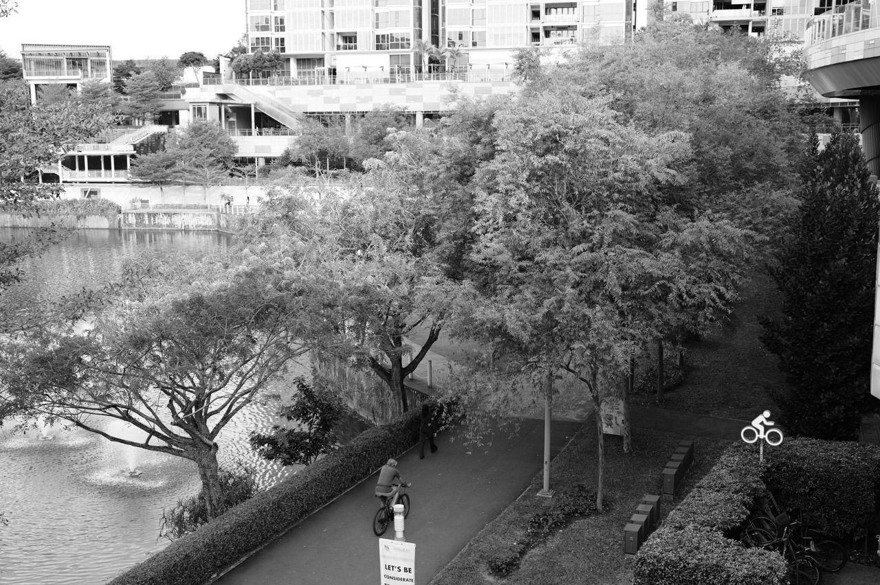
Punggol Waterway Park offers a real setting for noticing paths, vegetation, water and shared public space. A student can sketch an observation map from a safe public location and label only what is visible.
<figure class=”wp-block-image size-full”><img src=”https://edukatepunggol.com/wp-content/uploads/2026/10/edukatesingaporeleica04-10-2026-at-20.01.47-113.jpg” alt=”Running and cycling path at Punggol Waterway Park beside Waterway Point” /><figcaption>Paths, planting and public space in Punggol provide a local prompt for discussing access and urban ecosystem services.</figcaption></figure>
The next step is analytical. The learner can identify a likely cultural service, such as recreation, and a possible regulating role for vegetation. Then ask what evidence is missing to quantify those claims: usage counts, shade measurements, ecological observations or a defined comparison.
A photograph alone cannot prove water quality, ecological health, accessibility for every group or a reduction in air temperature. Learning to name the boundary of evidence is as valuable as recognising the features.
Worked Example: Hazard Preparedness Without Alarmism
Imagine a fictional neighbourhood with a busy road crossing, a public facility and a cluster of older residential blocks. Students are asked to propose steps to reduce everyday hazards and improve resilience.
Their answer might discuss traffic management, maintenance of built infrastructure, clear information, safe accessible routes and community preparedness. But which issue should be prioritised? That depends on evidence of likelihood, exposure, severity, feasibility and resident needs.
A good evaluation avoids treating all hazards as equally urgent. It also avoids implying that a particular real neighbourhood is unsafe simply because some buildings are older.
The educational aim is to practise risk-based, context-sensitive reasoning without sensational claims.
Fieldwork: Can Students Investigate Sustainability Safely?
A simple classroom or supervised fieldwork question might ask how shaded walking access differs along two selected routes. Students can define visible shade, choose comparable observation times and record route sections using a clear checklist.
The method should be safe, non-intrusive and appropriate to the school. Students should not obstruct public paths, collect identifying information without authorisation or enter restricted areas to complete an assignment.
Back indoors, they can create a small table, describe the recorded pattern and identify method limitations. Were both routes observed at the same time? Were category definitions consistent? Does the sample represent other days?
The companion Geographical Investigation and Fieldwork Skills guide explains how to build the full question-method-evidence chain.
How a Good Tutor Teaches This Topic
The tutor begins with a simple neighbourhood map or photograph the student has not seen before. First, the learner identifies features without interpretation. Next, they explain a possible service or hazard. Then they choose what evidence would be needed to test the claim.
If the student says “trees make the whole area cooler,” the tutor asks which temperature is meant and what comparison supports the statement. If the student claims “everyone can walk to the shop,” the tutor asks about route, distance and different users.
This is not being difficult for the sake of being difficult. It is the smallest practical repair to the student’s reasoning.
After guided practice, give a new map or situation and reduce the hints. Genuine progress appears when the learner starts asking those checking questions independently.
The Four-Week Sustainable Neighbourhoods Tuition Cycle
Week one — Systems and sustainability. Identify economic, social and environmental dimensions. Map homes, services, routes and green spaces, then connect each to a function and possible trade-off.
Week two — Ecosystem services. Practise provisioning, regulating, cultural and supporting services through unfamiliar examples. Distinguish a service from the evidence needed to establish its strength.
Week three — Hazards and resilience. Study fire, air-pollution and traffic hazards through mechanisms, exposure, vulnerability, prevention and community preparedness.
Week four — Fieldwork and transfer. Use a safe observation plan or a fictional dataset. Interpret the results and evaluate two neighbourhood improvements with stated criteria.
The pace should reflect the learner’s actual needs, and any formal school fieldwork must follow the school’s requirements. This is a diagnostic learning cycle, not a claim that every pupil becomes proficient in exactly four weeks.
Practice Tasks for Secondary Geography Students
Task one: The two-minute neighbourhood map. Label visible services, green spaces and transport routes. Describe one relationship between locations without inferring a cause yet.
Task two: Ecosystem service with proof. Choose a green feature, name one possible service and state what data would establish its effect.
Task three: Accessibility comparison. Compare two routes to a facility for an older person, a wheelchair user or a child. Explain which criteria matter and what the map omits.
Task four: Urban hazard chain. Pick a fire, air-pollution or traffic scenario. Identify hazard, exposure, vulnerability and a plausible management response.
Task five: Stewardship evaluation. Compare a one-off environmental event with a sustained programme. State the evidence needed to judge which offers a lasting benefit.
Task six: Transfer. Repeat the analysis for a different fictional neighbourhood. If the learner still uses the same reasoning sequence, the skill is becoming independent.
Common Misconceptions and Repairs
- “Sustainable means lots of trees.” Include economic, social and environmental dimensions and show how they interact.
- “All nature spaces provide identical benefits.” Identify the ecosystem, function and evidence.
- “A nearby service is accessible to everyone.” Consider routes, mobility needs, cost and time.
- “High density always means crowding.” Separate people per unit area from the lived capacity and design of spaces.
- “A pond automatically prevents flooding.” Verify actual water-management design and conditions.
- “Recycling bins mean waste is recycled.” Distinguish infrastructure from demonstrated outcomes.
- “A neighbourhood meeting guarantees resilience.” Explain participation, trust, information and the ability to act.
- “Hazard reduction eliminates every risk.” Identify which component of risk changes and what remains.
- “A photograph is enough to prove sustainability.” State the observation and what other evidence would be needed.
A targeted correction should change how the child approaches the next unfamiliar question, not merely improve one memorised paragraph.
Frequently Asked Questions About Sustainable Urban Neighbourhoods
Is sustainable development in the 2027 G3 Geography syllabus?
Yes. Sustainable Development is Topic 1.2 in Geography in Everyday Life for the 2027 G3 full Geography and Humanities Geography syllabuses. Students should follow their own assessment route.
Is sustainable urban neighbourhoods the same as Singapore’s national sustainability cluster?
No. They are related but different scales and content emphases. The neighbourhood topic examines everyday systems, services, hazards and stewardship; the full Geography Singapore cluster examines wider national characteristics and strategies.
What are ecosystem services in simple terms?
They are benefits associated with ecosystems, including provisioning, regulating, cultural and supporting functions. Students should explain what produces the benefit and what evidence would support a claim about it.
Does every urban park reduce flood risk?
Not automatically. Effects depend on the landscape, soils, vegetation and drainage or water-management design. A particular park’s hydrological contribution requires site-specific evidence.
Why is population density relevant?
Density can influence demand for shops, infrastructure and public transport, but the quality of accessibility and environmental conditions also matters. High density alone does not determine liveability.
What urban hazards should students recognise?
The syllabus includes fire, air-pollution and traffic hazards within sustainable urban neighbourhoods. Students should understand causes, consequences and appropriate risk-management concepts.
Can Punggol Waterway be an example?
Yes, as a real setting for observing public space, movement and vegetation. It should not be used to invent measurements or to assert that every visible feature performs a particular technical function.
What is environmental stewardship?
It means taking responsibility for caring for shared environments through suitable personal, community or institutional action. The effectiveness of any measure should be evaluated, not assumed from participation alone.
How can families practise at home?
On an ordinary safe walk, ask your child to name one useful connection, one ecosystem service and one question that would require data. Keep it conversational rather than turning the outing into a timed test.
How do I know Geography tuition is helping?
Give the student a new neighbourhood map and ask them to identify functions, explain mechanisms, distinguish evidence from inference and evaluate one proposed improvement. Look for fewer unsupported claims and stronger independent reasoning.
A Neighbourhood Is More Than the Sum of Its Buildings
Families who want the national perspective can continue to Sustainable and Resilient Singapore. Students who need the source-reading tools should begin with Map Reading Skills and Geographical Data Interpretation. The broader eduKate How Geography Works library provides the conceptual bridge between space, place and human–environment relationships.
For official course details, use the SEAB 2027 G3 school-candidate syllabus listings and choose the exact subject. For national nature strategy, see NParks City in Nature.
The nicest moment in a Geography tutorial is often a small one. A student walks past the same familiar patch of green and no longer says only, “It’s a nice park.” They notice the paths, the people, the habitat and the questions that remain unanswered. They can explain why the place matters—and how to make a more responsible judgement about its future. That is the core aim.


