
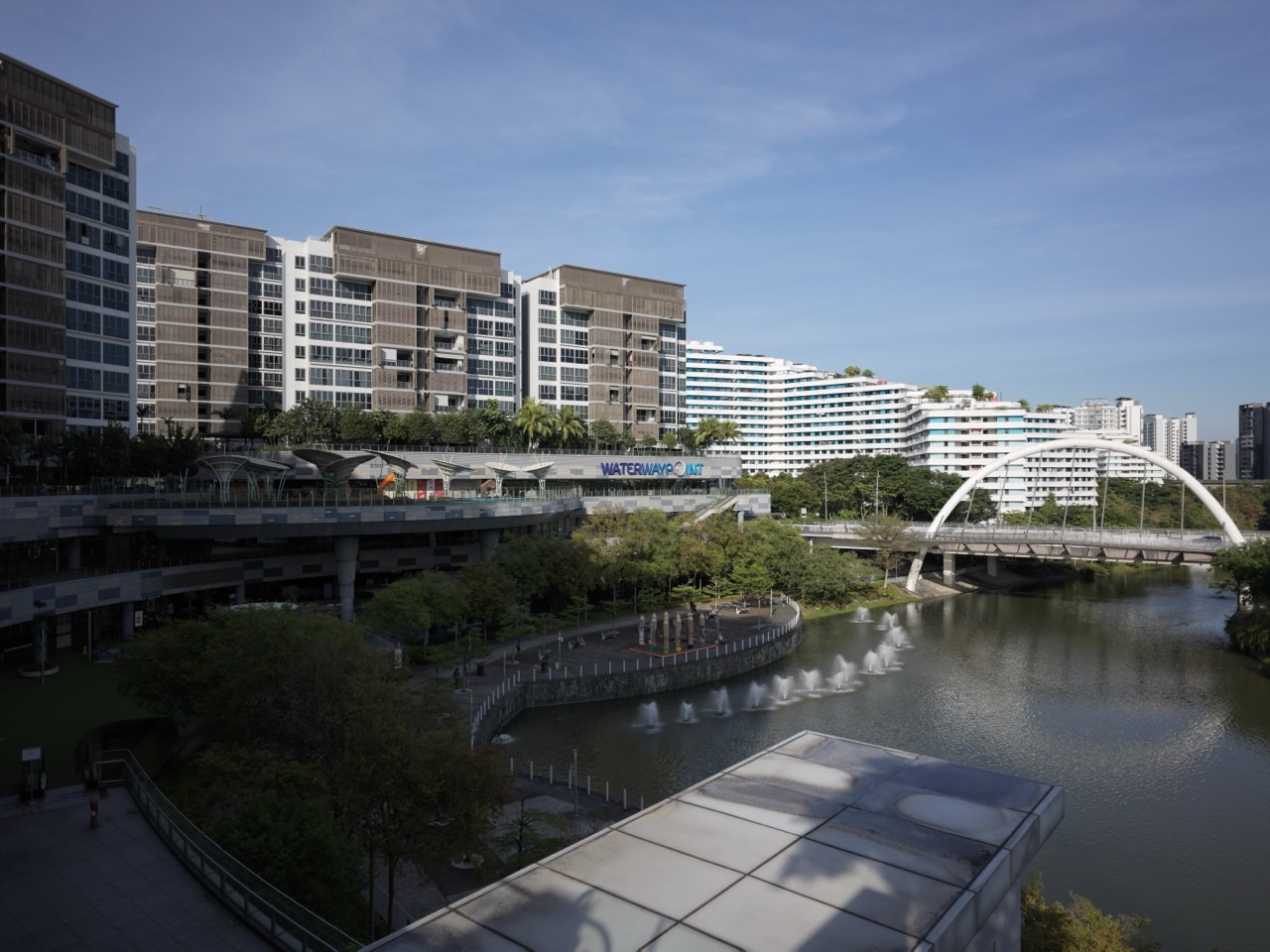
Punggol walking routes, cycling routes, Heritage Trail, Punggol Promenade and Campus Boulevard are not separate attractions accidentally placed near one another. Together they form the long linear systems that make Crazy Rich Punggol legible: routes that help people move, remember, orient themselves and reach water, homes, schools, transport and workplaces without every journey becoming a road trip.
Did you know? HDB’s Punggol Town Design Guide identifies five key corridor families: Punggol Waterway, Punggol Heritage Trail, Punggol Promenade, Campus Boulevard and Mobility Corridors. URA’s current Punggol Digital District guidelines add detail to the newer network: Old Punggol Road is preserved as an approximately 1.3 km walking-and-cycling Heritage Trail, while Campus Boulevard is designed as a minimum 18 m-wide pedestrian mall with at least 12 m for walking and cycling and landscaped strips on both sides, linking Punggol Coast MRT through the district toward the waterfront.
The Crazy-Rich Idea: A Town Is Wealthier When Its Important Places Are Joined by Good Journeys
Great destinations are not enough.
A library, park, station, waterfront, school or workplace becomes less useful when the route between them is confusing, exposed, indirect or hostile to walking and cycling.
Punggol’s corridors matter because they turn individual places into a network. The wealth is not only at the destination. It is in the journey remaining understandable.
The Waterway Corridor Is Punggol’s Blue Spine
Punggol Waterway runs through the town between the reservoir systems and is simultaneously landscape, movement route and public space. Bridges create crossings; promenades let people follow the water; housing and parks face it rather than treating it as leftover drainage land.
This corridor is easy to recognise because water does the wayfinding. Even without a map, people often know where they are in relation to the town by knowing where the Waterway lies.
The Heritage Trail Is Memory in Linear Form
Old Punggol Road survives as an undulating green route connecting the Waterway side toward Punggol Point. Its job is different from the Waterway corridor.
The Heritage Trail carries memory north. Its bends, vegetation and preserved alignment remind pedestrians and cyclists that the district had a road and landscape before the newest buildings arrived.
That makes heritage useful as movement rather than something visited only at a monument.
Punggol Promenade Turns the Coast Into a Public Route
The Punggol Promenade corridor follows the town’s coastal edge. It lets the coastline work as more than scenery by connecting recreation, cycling, walking, Punggol Point, the wider park-connector network and routes toward Coney Island and Lorong Halus.
Waterfront land is valuable. Keeping a continuous public route along it is therefore a deliberate kind of public wealth.
Campus Boulevard Is the Newest Kind of Punggol Corridor
Campus Boulevard does not preserve an old route. It creates a new one for a different Punggol.
URA requires it to connect Punggol Coast MRT to the waterfront as the primary public thoroughfare through Punggol Digital District. The corridor is designed for walking, cycling, shade, seating and social interaction between SIT and JTC developments, with barrier-free access along its length.
That makes it more than a campus street. It is an urban room stretched into a line.
Mobility Corridors Carry the Fast Movement
Not every corridor is meant to be slow and scenic. HDB also identifies major mobility corridors for vehicles and buses, including Punggol Central and the future east-west road connection.
The important design problem is how these faster corridors meet the walking-and-cycling network without breaking it. URA’s PDD guidelines repeatedly emphasise uninterrupted pedestrian connections, covered routes, ramps and barrier-free continuity where different movement systems cross.
Corridors Make Wayfinding Easier
People rarely navigate a familiar town by memorising every street name. They use strong mental lines.
- follow the Waterway;
- head north along the old-road green corridor;
- stay on the Promenade;
- walk down Campus Boulevard toward the coast;
- use the major road corridor to cross the town.
That is why HDB describes key corridors as contributing to wayfinding, orientation and imageable identity. A corridor is not only where movement happens. It helps the town become mentally readable.
Corridors Are Where the Eleven Districts Become One Town
Punggol’s 11 districts create local identity. Corridors perform the opposite job: continuity.
They let Matilda, Waterway, Northshore, Punggol Point, Downtown and Punggol Field remain distinct while still belonging to one connected geography.
districts create belonging; corridors create connection.
A Child Can Read Punggol as a Network
Ask a student to draw Punggol without starting with roads. Draw the Waterway, coast, Heritage Trail, Campus Boulevard and major transport corridors first. Then add stations, schools, parks and neighbourhoods around them.
The exercise reveals a powerful planning idea: places become easier to understand when the lines between them are designed as carefully as the destinations themselves.
Continue Through the Punggol Movement Story
For the Waterway itself, continue with Crazy Rich Punggol | Punggol Waterway, Reservoirs and the Luxury of Water as Public Life. For Old Punggol Road, read Crazy Rich Punggol | Old Punggol Road, Heritage Trail and the Luxury of Memory. For car-lite active mobility, continue with Crazy Rich Punggol | Walking, Cycling and the Luxury of a Car-Lite 10-Minute Town.
Current Official Sources
- HDB — Punggol Town Design Guide: Key Corridors
- URA — Punggol Digital District pedestrian connectivity, Heritage Trail and Campus Boulevard
The crazy-rich Punggol lesson is that a town does not become connected merely because roads exist. It becomes connected when the routes between important places are memorable, comfortable and useful enough to become part of everyday life.
Punggol is not held together only by centres.
It is held together by lines.
The Waterway runs through the town.
Old Punggol Road survives as a Heritage Trail running north.
The Punggol Promenade follows the coast.
Campus Boulevard cuts through the newer Punggol Digital District toward the waterfront.
Mobility corridors carry vehicles, buses, pedestrians and cyclists across the wider town.
Each corridor performs a different job. Together, they explain how a town that contains many districts, two increasingly strong centres, reservoirs, coastline, university, housing, parks and employment can still feel spatially connected.
HDB’s Punggol Town Design Guide formally identifies five key corridor families: Punggol Waterway Corridor, Heritage Trail Corridor, Punggol Promenade Corridor, Campus Boulevard Corridor and Mobility Corridors. HDB says these distinctive corridors contribute to wayfinding, orientation and the town’s imageable identity; they also support vehicular circulation, active mobility, walkability and the wider move toward a more car-lite urban environment.
This pillar owns that canonical question: how do Punggol’s long linear systems connect places, organise movement and give residents a readable mental map of the town?
For the complete Punggol reading system, return to the parent hub: What about Punggol?
The surrounding pillars keep their own ownership. How Punggol Waterway Works owns the water-security and reservoir mechanics. How the Punggol LRT Shapes the Town owns loop-and-station transport geography. Punggol’s Eleven Districts owns local identity. This article takes the lines that connect those pieces.
Why corridors matter in a large planned town
A town can contain many excellent destinations and still be difficult to understand.
A park here.
A school there.
A station somewhere else.
A waterfront at the edge.
Without strong relationships among them, the town becomes a catalogue rather than a system.
Corridors solve a different problem from centres.
A centre concentrates.
A corridor connects.
A centre says, “many things happen here.”
A corridor says, “follow this and the town will reveal itself.”
This is why strong corridors become wayfinding devices even for people who never read a planning map.
Follow the Waterway. Walk north on the Heritage Trail. Continue along the coast. Cross the Boulevard toward the waterfront.
Those instructions are spatially richer than a sequence of road names because each corridor has a recognisable physical character.
A corridor is not simply a path
Some corridors are mainly pedestrian.
Some carry cyclists.
Some carry vehicles.
Some are water.
Some combine several modes.
What makes them corridors is not one transport technology.
It is continuity.
A corridor creates a long relationship through space. Buildings, parks, junctions, bridges and public spaces respond to the same line. The line begins to organise what sits beside it.
This is why HDB’s corridor framework asks adjacent developments to respond, connect or engage with the corridor rather than behave as isolated plots.
Corridor 1: Punggol Waterway — water becomes a town spine
The Waterway is Punggol’s most recognisable corridor.
HDB identifies it as a key corridor running through Punggol and connecting Punggol Reservoir with Serangoon Reservoir.
Technically, the Waterway belongs to the town’s water system.
Spatially, it does much more.
- Housing faces it.
- Bridges cross it.
- Walking and cycling routes follow it.
- Town-centre public space meets it.
- Parks and planted edges use it.
- Residents use it as an orientation line.
This is one of Punggol’s defining planning achievements: infrastructure became legible enough to organise everyday movement.
NParks’ current park-connector material describes the Punggol Waterway corridor as a major leisure and active-mobility route built around Singapore’s largest man-made waterway.
The Waterway therefore demonstrates the corridor principle perfectly:
the line performs one engineering job while creating several urban jobs around it.
The Waterway Corridor changes what counts as “through the town”
Traditional town movement is often imagined along roads.
Punggol gives residents another internal axis.
A person can move through large parts of the town while following water rather than traffic.
That matters psychologically.
The Waterway becomes a continuous public realm rather than a sequence of isolated parks.
It also means districts along the Waterway can differ architecturally while still sharing one powerful town-wide reference.
The separate pillar How Punggol Waterway Works explains the 4.2 km water system in depth. Here the important fact is connectivity.
Corridor 2: Heritage Trail — Old Punggol Road becomes a green memory spine
The Heritage Trail performs an almost opposite historical move.
The Waterway is new infrastructure that became identity.
The Heritage Trail takes an old infrastructure line—Old Punggol Road—and converts it into a new walking, cycling and memory corridor.
URA’s current Punggol Digital District guidelines state that Old Punggol Road is to be preserved as an undulating heritage trail for walking and cycling. The planned Heritage Trail links Punggol Central northward toward Punggol Point and is approximately 1.3 km in length through the PDD area.
The physical route is important because it preserves continuity where the surrounding city has changed almost completely.
Roads are powerful memory devices.
A building can disappear while the route that once led past it survives.
A kampung can vanish while the direction of movement remains legible.
By preserving Old Punggol Road as a green corridor rather than simply erasing it beneath new development, the town keeps one historical line visible inside a future district.
The Heritage Trail is deliberately more than heritage interpretation
A heritage trail can easily become a line of plaques.
Punggol’s version is stronger because the trail is also useful movement infrastructure.
URA describes it as a walking and cycling connection.
It links Punggol Waterway Park toward Punggol Point Park.
It crosses the Punggol Digital District.
It intersects the new Campus Boulevard.
It must negotiate future roads without losing the sense of an uninterrupted green corridor to the northern coast.
This gives heritage everyday utility.
A resident does not need to be on a heritage excursion to use the historical route.
The route can become part of an ordinary journey.
As of 2026, the Heritage Trail is still becoming complete
It is important not to write the future as if it were already finished.
NParks’ current Punggol Heritage Trail page states that the trail is located within the newly developed Punggol Digital District and complements Punggol Waterway Park, Punggol Waterway and Punggol Point Park. NParks also notes that Phase 2 is expected to be completed by the end of 2026.
So there are two layers to describe carefully:
- the planned corridor logic — a continuous green heritage connection from the central Waterway area north toward Punggol Point;
- the delivered trail at the present moment — substantial portions are open, while the full current programme is still being completed.
That distinction preserves evidence discipline while still explaining the intended town-scale system.
Corridor 3: Punggol Promenade — the coast becomes a continuous public edge
The Promenade takes Punggol’s natural outer boundary—the coast and reservoir edge—and makes it publicly traversable.
NParks describes Punggol Promenade as a waterfront recreational destination linking Punggol Point with Punggol East and providing access to the north-eastern coastline.
The Promenade contains three thematic zones:
- Punggol Point Walk,
- Nature Walk,
- Riverside Walk.
The 2.4 km Nature Walk forms the middle section, with fishing platforms and rest shelters along the route. Riverside Walk continues along Serangoon Reservoir, while Punggol Point Walk connects the northern waterfront and park environments.
This creates a corridor with a very different character from the Waterway.
The Waterway is internal.
The Promenade is peripheral.
The Waterway brings water into the town.
The Promenade takes people out toward the town’s edge.
The Promenade converts an edge into a route
Edges can isolate.
A coast marks the place where land stops.
A reservoir forms another boundary.
A promenade changes the logic.
The edge becomes a linear destination.
Instead of moving perpendicular to the coast only to reach a viewpoint, people can move along the coast.
This increases the amount of waterfront that becomes part of public life.
It also connects important nature and recreation destinations, including Punggol Point and the approaches to Coney Island.
The Promenade therefore performs two jobs:
make the edge accessible, then make the accessible edge continuous.
Coney Island makes the Promenade part of a larger ecological network
NParks identifies Coney Island Park as an 81-hectare park beside Punggol Promenade Nature Walk.
The island’s west entrance connects near Punggol Point Walk and the Promenade, while the east side links toward Lorong Halus Wetland.
This extends the corridor idea beyond one administrative park.
A resident can move from housing landscapes into promenade, island, wetland and reservoir-edge environments through linked routes.
The separate article Can Punggol Grow Without Losing Coney Island? owns the development-versus-nature question. Here, Coney Island matters because it expands the corridor network into a much larger green-blue system.
Corridor 4: Campus Boulevard — a new pedestrian main street through Punggol Digital District
Campus Boulevard represents a very different generation of Punggol corridor.
It is not inherited from the old town.
It is not primarily a water body.
It is deliberately designed as a pedestrian-first public thoroughfare through the new education-and-employment district.
URA’s current Punggol Digital District urban-design guidelines specify Campus Boulevard as the primary public thoroughfare connecting Punggol Coast MRT Station at the Nexus to the waterfront.
The Boulevard is required to be at least 18 metres wide.
Within that width, URA specifies a minimum 12-metre pedestrian walkway and cycling path, flanked by 3 metres of landscaping on each side.
This is not a sidewalk enlarged slightly beside a road.
It is a public-space corridor with movement at its centre.
Campus Boulevard is meant to produce interaction, not only movement
URA describes the Boulevard as a well-shaded and vibrant pedestrian mall flanked by SIT and JTC developments.
Its intended social role is unusually explicit.
The space is meant to become a focal point for interaction and collaboration among education, research and industry.
Landscaping provides shade.
Ground-level porosity keeps adjacent developments connected to the public space.
Seating and informal breakout areas create reasons to stop rather than simply pass through.
This creates a stronger corridor model:
movement + shade + seating + active edges + institutional proximity = social corridor.
Campus Boulevard therefore tries to turn circulation into chance encounter.
The Boulevard crosses several vertical levels without giving up barrier-free continuity
Punggol Digital District sits on undulating terrain.
URA’s guidelines therefore control not only plan width but also the Boulevard’s vertical relationship with surrounding streets, the Heritage Trail, New Punggol Road and the waterfront.
The design is required to remain barrier-free through the full corridor, with ramps managing level differences.
This is important because a corridor can look continuous on a two-dimensional plan and still be difficult to use if vertical changes are poorly handled.
True connectivity is three-dimensional.
Campus Boulevard intersects history rather than replacing it
One of the most interesting moments in northern Punggol is the intersection between Campus Boulevard and the Heritage Trail.
One corridor is new.
One preserves an old road.
One runs east-west toward the waterfront.
One runs north-south toward Punggol Point.
The crossing therefore becomes a spatial argument about time.
the future district does not need to erase the historical line in order to become new.
Instead, the new corridor can cross and reinforce the old one.
The Boulevard also extends beyond PDD
URA’s framework includes a Boulevard Extension westward through the landed housing area and onward to the waterfront at Northshore.
The extension is planned as a minimum 15-metre-wide pedestrian mall.
Existing roadside Rain Trees are to be retained where relevant so the route can become a shaded public connection rather than a bare new corridor.
This expands Campus Boulevard from a district spine into a connector between several urban conditions:
- Punggol Coast MRT,
- SIT,
- JTC/PDD workplaces,
- Heritage Trail,
- waterfront promenade,
- Northshore.
The corridor is therefore not merely campus circulation.
It is part of the town-scale mobility network.
PDD also keeps a direct north-south connection back to Punggol Town Centre
A new district can accidentally turn its back on the older town.
URA’s current guidelines address that risk explicitly.
A roadside cycling-and-pedestrian path along Sentul Crescent Extension is intended to connect Campus Boulevard southward toward Punggol Town Centre.
This relationship matters because Punggol now has two strong centres:
- the established MRT–Waterway Point–Town Square centre;
- the emerging Punggol Coast–SIT–PDD centre.
The stronger the walking and cycling connection between them, the more likely they behave as complementary parts of one town rather than competing islands.
The existing article Punggol Coast Is Becoming a Second Centre of Gravity owns the second-centre question. The corridor story explains one of the connections that makes two centres possible.
Teck Lee adds another east-west connection to the waterfront
URA also requires a covered walkway of at least 3.6 metres width connecting Teck Lee LRT to the waterfront across Punggol Digital District.
The route links with Campus Boulevard and crosses the Heritage Trail.
This is a useful example because it shows the difference between a corridor network and one flagship boulevard.
Campus Boulevard is the primary public spine.
But additional links feed into it.
The network gains strength from intersections.
Corridor 5: Mobility Corridors — the road network still matters
A car-lite town is not a car-less town.
Deliveries still need access.
Buses need roads.
Emergency services need roads.
Some residents and trips will continue to require private vehicles.
HDB’s key-corridor framework therefore includes Mobility Corridors for vehicular movement, including the Punggol Central axis and the planned east-west road connection linking toward Seletar and Pasir Ris.
The important planning shift is not to eliminate roads.
It is to prevent roads from being the only strong organising lines in the town.
Punggol’s corridor hierarchy distributes movement across several systems:
- roads for vehicles and buses,
- LRT and MRT for rail,
- Waterway and promenade paths for active mobility,
- Heritage Trail for walking and cycling,
- Campus Boulevard for pedestrian and cycling priority.
That is the deeper meaning of car-lite planning.
People gain alternatives.
The strongest corridors are multimodal even when one mode dominates
Punggol Waterway is visually dominated by water, but people walk and cycle beside it.
Heritage Trail is pedestrian and cycling territory, but it intersects roads and MRT infrastructure.
Campus Boulevard prioritises walking and cycling but links directly to MRT, bus and surrounding developments.
Mobility Corridors carry vehicles but must still negotiate pedestrian crossings and active-mobility routes.
The town therefore works through interfaces among modes rather than through perfect separation.
Intersections matter more than individual corridors
A corridor is valuable on its own.
A network becomes valuable through intersections.
Consider several important Punggol intersections:
- Heritage Trail meets Campus Boulevard.
- Campus Boulevard meets the waterfront promenade.
- Heritage Trail connects toward Waterway Park.
- Teck Lee’s covered connection crosses the Heritage Trail and links into Campus Boulevard.
- Punggol Promenade connects toward Coney Island.
- The Waterway ties into Town Centre and multiple district routes.
Each intersection creates route choice.
Route choice creates resilience.
A resident can alter a journey based on destination, weather, crowding or preference.
Wayfinding improves when corridors look different
HDB’s guide explicitly connects key corridors with wayfinding and imageable identity.
This matters because navigation is easier when routes have distinct sensory signatures.
The Waterway feels like water and bridges.
The Heritage Trail feels greener and historically quieter.
The Promenade feels coastal.
Campus Boulevard feels urban, institutional and pedestrian-focused.
A mobility corridor carries stronger road infrastructure.
These differences reduce cognitive load.
A person can orient through character rather than signs alone.
A corridor can become a memory sequence
People remember journeys as sequences of events.
Cross the bridge.
Pass the old road.
Reach the shaded Boulevard.
See the waterfront.
Turn toward Coney Island.
These repeated sequences become more memorable than anonymous distance.
Corridors therefore organise not only space but memory.
The Heritage Trail is especially powerful because the route itself is the artefact
Most heritage preservation focuses on objects.
A house.
A monument.
A tree.
Old Punggol Road is different.
The heritage value lies partly in linear continuity.
The road was historically a way of reaching the northern coast.
Preserving the line allows future residents to move through part of the same orientation, even though the surrounding landscape has changed.
The existing article Old Punggol Road: Why a Future Town Still Needs Memory owns the deeper heritage argument. This corridor pillar explains why linear continuity matters to the town network.
Campus Boulevard demonstrates a twenty-first-century main street without cars at its centre
Traditional main streets usually combine vehicles, footpaths, shops and civic activity.
Campus Boulevard rearranges the hierarchy.
Walking and cycling become the primary public movement through the Boulevard itself.
Adjacent education and employment uses generate footfall.
Shade and seating make stopping possible.
The MRT anchors one end of the movement chain.
The waterfront anchors another.
This is transit-oriented urban design expressed as public space rather than road capacity.
The corridor system reduces the importance of one perfect route
A robust town should not depend on one ideal path for every trip.
Different journeys need different routes.
A commuter may prioritise speed.
A runner may prioritise continuity.
A family may prioritise shade and safety.
A cyclist may prioritise uninterrupted distance.
A visitor may prioritise scenery.
A person with mobility needs may prioritise barrier-free gradients.
Multiple corridors let the town serve these different objectives without demanding that one street solve all of them.
Corridors also redistribute commercial and social opportunity
People create activity.
Routes determine where people pass.
Therefore routes influence where activity can accumulate.
A well-used pedestrian corridor can support cafés, seating, community activity and informal encounter.
A waterfront promenade can support recreation and dining destinations.
A trail can bring visitors through a heritage landscape.
Campus Boulevard is explicitly designed around this principle, using institutional frontage and breakout spaces to encourage interaction rather than treating the route as empty circulation.
Corridors have edges, and edges determine whether the corridor succeeds
A beautiful path between blank walls is still weak urbanism.
A corridor becomes more useful when its edges engage it.
Buildings can provide entrances.
Shops can face the route.
Seating can occupy shaded zones.
Landscape can create ecological continuity.
Community uses can spill into public space.
This is why HDB asks adjacent developments to respond to key corridors, and why URA’s Campus Boulevard rules pay close attention to porosity, seating and interfaces with SIT and JTC buildings.
Crossings are the weak points of continuity
Every corridor eventually meets something that wants to interrupt it.
A road.
A rail line.
A level change.
A development parcel.
These crossings are where the quality of the system is tested.
URA’s Heritage Trail guidelines explicitly warn that intersections with the future arterial road, roads in Punggol North and the Integrated Transport Hub must be handled carefully to preserve an uninterrupted green corridor toward the northern coast.
This is a general rule:
a corridor is only as continuous as its hardest crossing.
Barrier-free design is corridor engineering
Accessibility is not something added after the route is drawn.
If a corridor contains steep level changes, stairs without alternatives or discontinuous crossings, it does not function equally for all residents.
URA’s PDD requirements therefore specify barrier-free accessibility throughout Campus Boulevard and the Teck Lee connection, with ramps managing level changes.
This matters for:
- wheelchair users,
- older residents,
- parents with prams,
- people carrying loads,
- children on bicycles,
- temporary injuries.
Universal access increases the number of people for whom the corridor is genuinely continuous.
Tropical comfort determines whether people actually use a corridor
A corridor can be perfectly connected on a map and unpleasant in real life.
Singapore’s sun and rain raise the standard.
Campus Boulevard is required to be well shaded.
The Boulevard Extension is designed to retain existing Rain Trees where relevant.
The Teck Lee connection is covered.
Promenade routes include shelters.
The Heritage Trail is conceived as a lush green route.
These are not decorative details.
They determine the effective hours during which people are willing to walk or cycle.
The earlier pillar Punggol’s Tropical Design owns heat, wind and shade in depth. Here, climate comfort is one requirement for corridor performance.
Systems view: five corridor families, one town network
The corridor system can be understood as five different spatial technologies.
1. Waterway Corridor — internal blue spine
Connects reservoirs, parks, housing districts and active-mobility routes through the middle of the town.
2. Heritage Trail Corridor — north-south memory spine
Preserves Old Punggol Road as a walking and cycling route linking the Waterway area through PDD toward Punggol Point.
3. Punggol Promenade Corridor — coastal public edge
Runs along the waterfront, connecting recreation, nature and reservoir/coastal landscapes.
4. Campus Boulevard Corridor — new pedestrian urban spine
Connects Punggol Coast MRT, SIT, PDD workplaces, Heritage Trail and the waterfront through a wide, shaded walking-and-cycling public space.
5. Mobility Corridors — vehicular and bus movement framework
Carry the road-based movement the town still requires and interface with the pedestrian, cycling and rail networks.
None is sufficient alone.
The network appears through their overlap.
What can go wrong?
Corridor planning has characteristic failure modes.
- Discontinuity: one difficult road crossing can break an otherwise excellent walking route.
- Blank edges: a corridor can feel empty and unsafe when adjacent developments do not engage it.
- Heat exposure: an unshaded path may exist physically but fail as attractive active-mobility infrastructure.
- Wayfinding ambiguity: too many similar routes can reduce the corridor’s cognitive identity.
- Mode conflict: fast cyclists, slow walkers and service vehicles can compete for limited space.
- Accessibility gaps: level changes or narrow links can exclude users.
- Fragmented delivery: a planned town-scale corridor may remain weak for years if adjacent phases are incomplete.
- Heritage dilution: a historical corridor can retain its name while losing the physical qualities that made it meaningful.
- Overcommercialisation: public corridors can become less civic if every useful stopping point depends on transactions.
The response is not to avoid corridors.
It is to evaluate continuity, edge quality, climate comfort, accessibility and actual use—not only whether the line appears on the master plan.
The best corridor metric may be how many different journeys it can support
A corridor becomes resilient when it is useful to different people for different reasons.
The Waterway can serve a commuter cyclist and an evening walker.
The Heritage Trail can serve a student travelling north and a resident exploring local history.
The Promenade can serve a runner, angler, family and nature visitor.
Campus Boulevard can serve SIT students, office workers, cyclists, visitors and residents heading toward the waterfront.
Multi-use increases the amount of the day during which the corridor has people and purpose.
For a child, corridors turn Punggol into a map that can be walked
A child can learn geography by following one continuous route.
Begin at the Waterway.
Move toward Old Punggol Road.
Follow the Heritage Trail north.
Cross Campus Boulevard.
Continue toward the coast.
Join the Promenade.
Inside that single journey are several urban ideas:
- water infrastructure,
- heritage preservation,
- active mobility,
- digital-district planning,
- coastal geography,
- public-space design.
The map becomes an experience rather than an image.
For Mathematics, corridors are network edges
Punggol’s corridor system can be modelled as a graph.
Centres and intersections are nodes.
Corridors are edges.
A student can ask:
- Which route minimises distance?
- Which route minimises exposure to roads?
- How does adding one bridge change network connectivity?
- What happens to travel time when a corridor is interrupted?
- How many useful route combinations appear when two corridors intersect?
The geometry of the town becomes mathematical because connectivity can be measured.
For History, corridors reveal which lines survived redevelopment
Punggol has been physically transformed so extensively that many historical spatial relationships disappeared.
The Heritage Trail is valuable precisely because one old line survives through that transformation.
The Promenade shows a different historical change: coastline that was once less publicly accessible has become a continuous recreational edge.
The Waterway shows an entirely new line inserted into the town.
Campus Boulevard shows the newest generation again.
Read together, the corridors form a chronology:
old road → reclaimed and planned town → new Waterway → coastal public realm → digital-district pedestrian boulevard.
Punggol’s history can therefore be read not only through buildings but through lines of movement.
The final return: what do Punggol’s corridors actually do?
They make distance readable.
They connect districts.
They give walking and cycling continuity.
They preserve memory.
They expose the coast.
They connect Punggol’s original centre to its emerging northern centre.
They allow institutions to face public space rather than internal roads alone.
They create alternatives to car-only movement.
Most importantly, they convert a collection of destinations into a town that can be understood as a continuous system.
A centre gives Punggol somewhere to arrive. A corridor gives Punggol somewhere to continue.
That is why the lines matter.
A corridor is useful when movement remains continuous
The educational value of a corridor is not only that two places are connected on a map. A corridor becomes meaningful when people can actually move through it with understandable transitions, useful anchors, reasonable effort and enough redundancy that one small disruption does not make the whole line unusable.
This gives students a stronger systems question: what makes a route continuous in practice?
Use five corridor tests
- Legibility: can a person understand where the corridor goes?
- Continuity: are there awkward breaks or missing links?
- Accessibility: can different users move through it?
- Resilience: is there an alternate path when one segment fails?
- Purpose: what destinations or activities does the corridor connect?
These tests help the child see a corridor as infrastructure plus use, not merely a line drawn between landmarks.
Corridors create sequence
A good corridor lets people experience the town as a chain of connected places. Waterway, promenade, neighbourhood, campus, transport and civic spaces begin to make sense in relation to one another.
For children, that sequence is a practical lesson in geography: locations gain meaning through connection.
Use corridor walks to teach mental mapping
Ask the child to identify anchors, direction changes, crossings, decision points and alternate routes. The learner should eventually be able to describe the corridor without relying entirely on a phone map.
This supports the broader Punggol Wayfinding for Families system while keeping this page focused on the town-scale line.
A corridor can reduce transfer cost
When routes connect cleanly, people spend less time reorienting, waiting or making unnecessary detours. That can make walking, cycling or public-transport combinations more practical.
Students can measure the effect through route time, number of decision points or the amount of exposed walking rather than relying on vague statements that a corridor is “better connected”.
Accessibility reveals whether the corridor works for more than one user
A route that is easy for a confident teenager may be difficult for a wheelchair user, family with a stroller, older adult or child carrying sports gear. Lifts, slopes, crossings, surface quality and sheltered links can change the practical experience.
The corridor should therefore be read from several user perspectives, not only from the fastest traveller’s viewpoint.
Use corridor redundancy as a resilience lesson
If one segment is closed, crowded or affected by weather, can the traveller continue by another reasonable route? A corridor with alternatives may be more useful than one whose entire logic depends on a single fragile connection.
Children can learn that resilient systems preserve function even when one part is disturbed.
Corridors shape where activity concentrates
Movement lines influence which places people pass, notice and use. A corridor may support shops, public spaces, transport nodes, campuses or recreational areas simply because repeated movement makes them easier to encounter.
This does not mean the corridor alone causes all activity. It means access is one factor shaping how places become connected to everyday life.
Use one corridor diary
For one month, the child can record how the family uses one corridor: school journey, weekend walk, library trip, tuition route, park access or family errand. Note which segments are repeated and which anchors matter most.
The diary turns an abstract urban-design concept into evidence from ordinary movement.
The deeper lesson is continuity across scale
A household route connects to a neighbourhood path; the neighbourhood path connects to a town corridor; the corridor connects to larger transport and public-space networks. Children can see how a small journey sits inside a larger spatial system.
That is what makes corridors educational: they show how local movement, town structure and wider connectivity fit together.
Continue through the Punggol pillar system
- What about Punggol? — parent hub for the complete Punggol reading system.
- How Punggol Waterway Works — the water-security and public-life mechanics of Punggol’s internal blue corridor.
- How the Punggol LRT Shapes the Town — loops, stations and last-mile rail geography.
- Punggol’s Eleven Districts — local identities connected by the town-scale corridors.
- Old Punggol Road: Why a Future Town Still Needs Memory — the deeper heritage story beneath the Heritage Trail.
- Punggol Coast Is Becoming a Second Centre of Gravity — the new northern centre that Campus Boulevard helps organise.
Evidence anchors
The factual spine of this pillar is grounded in current official Singapore planning and parks material. HDB’s Punggol Town Design Guide formally identifies the five key corridor families—Punggol Waterway, Heritage Trail, Punggol Promenade, Campus Boulevard and Mobility Corridors—and explains their role in wayfinding, orientation, active mobility, walkability and town identity. URA’s current Punggol Digital District Urban Design Guidelines detail the approximately 1.3 km Heritage Trail, the 18 m-wide Campus Boulevard, its minimum 12 m walking-and-cycling zone, landscaped edges, barrier-free requirements, Boulevard Extension and connections to Punggol Town Centre, Teck Lee LRT and the waterfront. NParks’ current Punggol Heritage Trail page records the presently delivered trail and notes that Phase 2 is expected to be completed by the end of 2026. NParks’ Punggol Promenade Nature Walk material describes the Promenade’s three thematic zones and its role linking Punggol Point with Punggol East, while its Punggol Waterway and Coney Island material establishes the wider park-connector network. Interpretive passages distinguish current delivered conditions from planned future connections.
Return to the parent hub: What about Punggol?


