
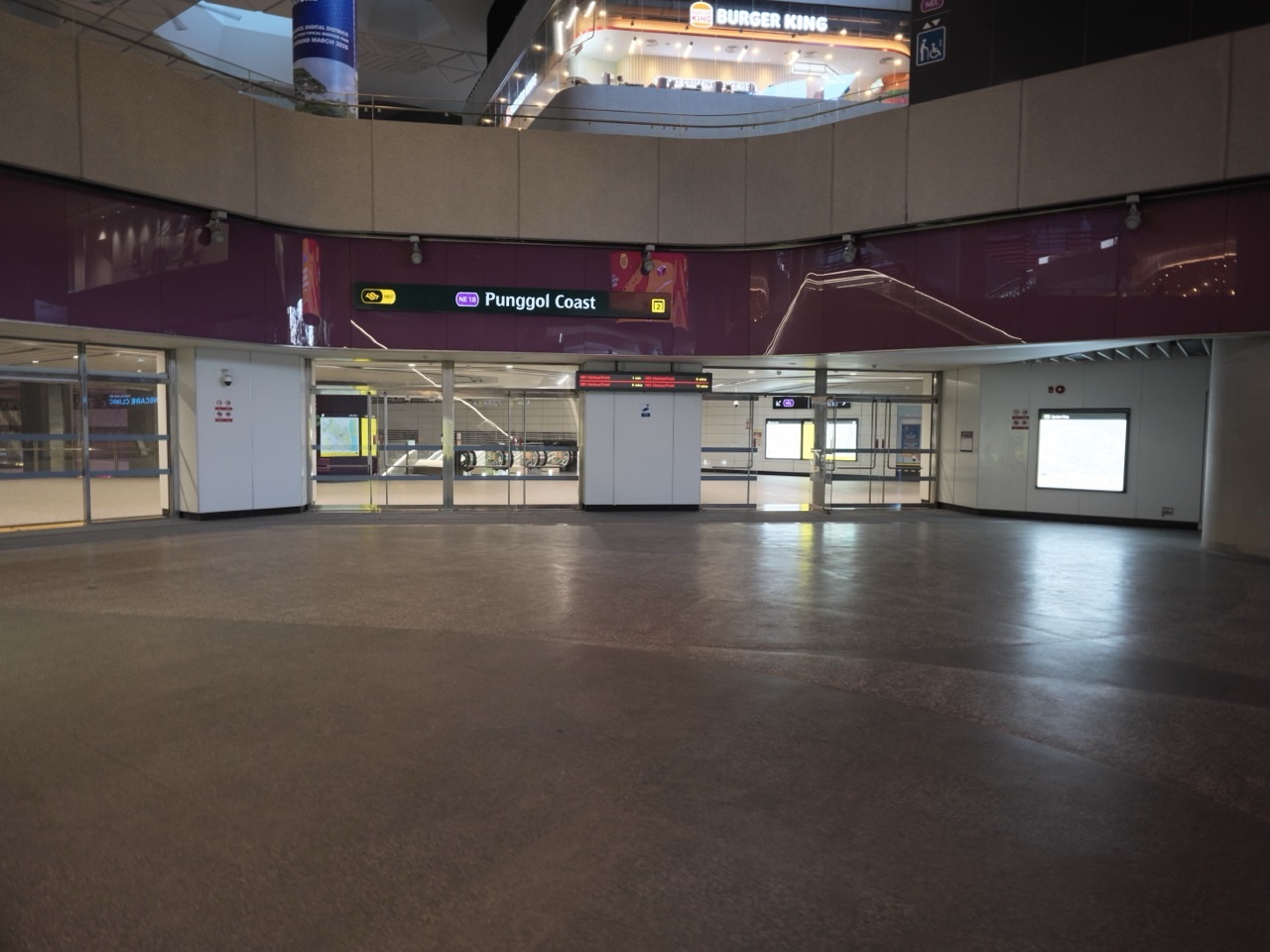
Choose Coney Island’s West Entrance if you are starting on the Punggol Coast side and have confirmed an open public route to the gate. Choose the East Entrance if you are approaching from the Lorong Halus side and have checked that route instead. NParks currently lists the park as open from 7am to 7pm. Plan to be outside the gate well before closing, including time for a slower return than you expected.
Punggol Coast MRT is the nearby rail station listed by NParks, but the station and the island gate are separate destinations. Save the gate itself and check the public approach before going. The status of Punggol Point Park, the surrounding connectors and Coney Island can differ. A short out-and-back from one confirmed gate is the easiest first trip.
- West Entrance: use the Punggol Promenade or Punggol Point side only when your specific approach is open.
- East Entrance: plan the Lorong Halus side separately and check how to get home from there.
- Current park hours: 7am to 7pm, subject to updated notices.
- For a first visit, leave from the same gate you used to enter.
- Keep a separate backup if weather, works or group comfort changes the plan.
EDUKATE PUNGGOL · SINGAPORE 2027
Find the part you need
- Pick the gate by the approach and the return
- Plan the western approach from Punggol Coast
- Plan the eastern approach near Lorong Halus
- Choose a trail that fits the terrain and the group
- Frequently asked questions
First stops and visit planning
Activities, practical tips and FAQs
- Read the three sources in the order you will use them
- Give the walk a real turnaround, not only a finish time
- Plan for facilities, food and transport outside the park
- Keep a useful record of the route you took
- Recheck the trip on the morning you go
- Consider how close you want to get to the coast
- Frequently asked questions
NParks lists two public entrances. The West Entrance is near Punggol Point Walk and Punggol Promenade. The East Entrance is near Lorong Halus Wetland. These locations are close enough on a map to be confused with an easy through-route. In practice, the best gate depends on where you start, which connectors are open and how you plan to leave. The return route should be part of the decision from the beginning.
A first-time visitor from the North East Line may find Punggol Coast the simplest rail reference for checking the western approach. A resident already on the Lorong Halus side can start with the eastern gate if the path is suitable. If you are deciding between the two from home, find the exact gate and work backwards to the train, bus, car or cycling route. Choose the end where you can explain both the approach and the return.
Use one gate for a shorter family visit
An out-and-back from a single gate has fewer decisions. You can choose a short section, turn while everyone still has energy and leave through a place you recognise. That works especially well when you are visiting with children, grandparents or someone who needs to check the surface before going farther. It also gives you an easy option when the weather changes.
A through-walk can be worthwhile when the walking itself is your main objective. Check the open path inside the island as well as the way from the second gate to your next destination. A point-to-point walk is only convenient if both ends suit the people using it. Give yourselves a clear finish and an alternative in case one end is affected by a closure or the group needs to turn back.

Start by saving Punggol Coast MRT and Coney Island West Entrance as separate pins. Check the current park map, connector notice and station wayfinding. Use open public paths and follow the signs on the day. The MRT is a transport reference. It does not establish that a particular connector, street crossing or shortcut is available at the time you visit.
If your group wants to meet near the station, use a named exit or a recognisable public point. A meeting at the gate is easier only when everyone understands how to reach it. When arriving separately, tell the group whether the outing starts at the station or at the actual island entrance. A person who arrives at Punggol MRT or Waterway Point will need a different onward route, so send the full station name.
Keep Punggol Point Park separate from the island
Punggol Point Park is a distinct site near the western approach. Closure information for that park or its adjacent parking area should be read for its exact scope. It does not automatically decide whether Coney Island or every nearby connector is accessible. Check the park notices and on-site signs before trying any western approach. If a route is fenced off or unsigned, turn back to the last suitable public connection.
A 2027 completion target mentioned in an older notice is useful context, but access depends on the current notice and the signs you encounter. Do not plan on entering any hoarded park area or using a carpark simply because a general park page describes normal hours. Treat the station, route, carpark and gate as four separate checks. If you have confirmed the gate but cannot confirm the approach, choose a different itinerary until both are clear.
Contents · Previous section · Next section

Use the NParks Coney Island map and look for the East Entrance near Lorong Halus Wetland. If you are starting on the Punggol Promenade side of Serangoon Reservoir, check Lorong Halus Bridge and the relevant approach before trying to use the wetland side. The wetland, bridge and island gate are separate points. A family coming from another direction should use the route appropriate to that side rather than assuming the bridge is part of every eastern approach.
If the wetland is your first objective, give it a clear time and decide at a suitable public point whether to continue. The island gate is an additional destination with its own closing time. A child may enjoy a short public view near the reservoir and be ready for a meal before the island portion. That is a complete outing. You can use the separate water science walk to plan a visit focused on Lorong Halus alone.
Check your transport from the gate you actually use
The eastern end should have a planned onward route before you leave the west side. Look at the station, bus stop or designated pickup point you intend to reach. A name close to the gate on a map may still require more walking. A group that has already spent a long time outdoors can find this last stretch more tiring than expected.
If you are meeting someone who does not want to walk on the island, choose a confirmed public point outside the gate or a venue near your return transport. Share the expected finish and keep the longer route optional. If conditions are poor, the group can go directly to the fallback without asking someone to wait near an exposed path. This is especially useful when a through-walk is planned near the end of the day.
Contents · Previous section · Next section
NParks currently lists 7am to 7pm for Coney Island Park. Treat those as park access hours and allow time to get out before closing. The practical cutoff for a family depends on its route and walking speed. Set an earlier turnaround than the time you think you need, then add a margin for rest stops, route checks and an unexpected delay. If you arrive late, keep the walk short or return another day.
Suppose a family has one hour before it needs to leave the island. A 20-minute outward leg and a 20-minute return already take most of that time, before photographs and a short pause. A sensible version would start turning before the outward leg reaches 20 minutes. The family can still enjoy a view and leave without watching the clock for the entire visit. Treat this as an example rather than an estimate of the distance to a landmark.
Avoid relying on a shortcut near closing
A path that looks like a quicker way out may be closed, unsuitable or lead somewhere other than the gate you want. Use the confirmed public route and turn early enough to follow it. When travelling in a group, make sure everyone knows when the decision to turn will happen. A person taking photos can watch the same time as the rest of the group. Waiting until someone is tired gives you fewer comfortable choices.
If the park is already closed or the gate approach is unavailable, use an appropriate public alternative outside the park. Do not enter through an unofficial path or past signage. Choose a meal, a signed accessible waterfront stretch or another day. A clear alternative is particularly helpful when visitors have travelled a long way to get to Punggol.
Contents · Previous section · Next section
NParks describes the ends of the park as wheelchair accessible and stroller friendly, while also identifying more rugged parts. Check the actual route and surface for the part your group plans to use. A gate that can be reached with wheels does not tell you how every trail inside will feel. The shortest suitable path can give you a good island visit while leaving the rougher sections for another group or another day.
If an older visitor wants frequent stops, agree on one comfortable place to pause and return from it. If you are with a stroller, consider what the surface might be like after rain. When a path becomes too rough or the group has already had enough, turn back to the same gate. Look for a comfortable place away from the through-route before stopping to talk or check directions.
Plan cycling as a separate trip
If you are cycling, check the route, equipment and return arrangements before setting off. NParks lists bicycle parking at both entrances. That does not establish that a rental shop will be open or that a particular operator allows a return at another site. Confirm those details with your provider. Give the slowest rider a clear pace and use current shared-path markings and public notices.
With mixed walkers and riders, choose a shared return point rather than expecting the two groups to cover the same distance. Agree on a time and the correct gate. The walking group can enjoy a short section while the riders use a suitable route of their own. The safest plan is one the group can explain without opening another map at every crossing.
Contents · Previous section · Next section
Coney Island is a nature park with rustic paths and varied habitats. Stay on designated trails and observe from a distance. Follow NParks’ current park rules and wildlife advice. A child can look at the shape of a tree, notice a sound or compare a shaded stretch with a more open one. Keep wildlife sightings as a bonus. No particular animal is guaranteed, and approaching or feeding wildlife can create problems for both people and animals.
Bring water and dress for the conditions. NParks recommends long pants and covered shoes for insect protection. Use the current visitor information before choosing how to prepare. If the weather becomes stormy, use appropriate indoor shelter and leave the exposed route until conditions improve. A short visit can be more enjoyable than a longer plan built around a beach or boardwalk that you have not checked.
Use photographs as an approach reference
The archive images in this guide show Punggol Coast MRT and nearby connector settings, rather than the island gates themselves. Use the official park map and current signage for gate identification. If you take your own picture at the park, label the gate or trail accurately. A photo made at one entrance can be confusing if a reader assumes it shows the other end or a still-open route.
Ask a child to notice one thing inside the park that looks different from the mainland path. They might compare surface, shade, planting or how people use the space. Talk about what they actually saw. You can finish the activity by drawing two small pictures or telling someone what changed when you went through the gate.
Contents · Previous section · Next section
West gate and a short same-gate return
Begin with the current approach from Punggol Coast and confirm that it reaches the West Entrance through public paths. Walk a short way into the park, pick a clear turnaround and leave through the same gate. Use a meal or drink near the transport end of the trip if the group wants a second stop.
Lorong Halus first, then decide about the east gate
Reach the wetland side using a verified route and take a short look at the setting. If the group still wants to continue and the gate is accessible, walk to the East Entrance and keep the island visit short. If the route or time does not work, finish the wetland trip and return.
Through-walk for a group with more time
Check both gates, the route inside the park and transport after the exit. Plan an earlier start and identify a point where you can still turn back. Bring what you need and make a decision early if conditions change. A crossing can be a satisfying outing when the route is clear and everyone wants the distance.
Contents · Previous section · Next section
Start with the NParks park page to confirm the gate names, park hours and map. Next read the current notices for the particular park connector or neighbouring area your route uses. Finally, check on-site signs. The park page describes the destination, the notice describes changes and the sign confirms what you can do at the point where you are standing. Reading all three reduces the chance of treating an open park as proof of an open approach.
An older guide may still be useful for orienting yourself. Its directions can describe a path that used to be the easiest approach. Use a current route and operator notice to decide whether it is usable for your date. When an information page and an on-site sign appear to conflict, follow the sign and find a suitable public alternative. That is especially important around upgrading work, temporary barriers and coastal paths.
Keep a comparison of the two ends
For the West Entrance, the main question is whether your actual route from the Punggol Coast side reaches the gate through open public paths. For the East Entrance, the main question is whether your approach on the Lorong Halus side and onward journey work for the group. For both ends, check the intended surface, gate hours and return. A good choice gives you answers to the two-way journey, rather than only to where you want to start.
Someone might choose the western gate for rail access and the eastern gate on another day because they are already visiting the wetland. Neither gate has to be better in general. The easiest route is the one that fits the starting location, the pace of the people coming and the most reliable way back. If you can explain the approach without guessing, you are ready to plan the length of the walk.
Contents · Previous section · Next section
A finish time is useful when everyone knows when they need to be out. A turnaround gives the family a point where it can decide to go back. Choose a visible landmark or a set period of walking, then allow time for the path you already covered. If the return is the same way, remember that stopping for a rest or a photo uses the time available before closing. If you want to keep walking, make sure the return still fits comfortably.
Suppose a family enters in the afternoon and has a fixed dinner. It can pick a short stretch and a clear time to turn, then give itself a margin outside the gate for the return to transit. Someone using a wheelchair or pushing a stroller may need extra time on a rough section. Give that person the chance to call the turnaround early. It is easier to enjoy the island when nobody is expected to cover a distance they did not agree to.
Know what changes on a through-walk
When you use both gates, the second one becomes part of the travel plan rather than a scenic waypoint. Check what you will do after leaving it and how that differs from the first gate. If you are using a rental bicycle, verify the return conditions. If you are walking with friends, agree where to regroup if someone goes more slowly. The time you need to get home can be different on each side.
A through-walk does not require a particular photo stop, beach or side path. You can keep the main route and leave extra sections optional. Check the current park map before adding a detour. If one end becomes unsuitable, decide early whether to turn back. The point of planning both gates is that you still know what to do when you cannot use the original route.
Contents · Previous section · Next section
Take drinking water and anything essential before entering. Use the current NParks map and information for facilities, rather than assuming there is a shop, toilet or sheltered place at the next bend. Choose a meal near the station or return point if it helps the family. People with young children may want a toilet stop and a drink before the longer approach to the gate.
If you are arranging a pickup, identify an accessible public point outside the park where vehicles can actually reach you. Do not send the pin of an island gate to a driver without checking whether that is a suitable destination. If you need to meet someone near the station afterwards, share the time with enough margin for the route from the gate. A comfortable return can matter more than the last kilometre of the walk.
Use a backup that matches your gate choice
A western-side trip may switch to a confirmed public destination near Punggol Coast if a connector is unavailable. An eastern-side trip can remain a shorter visit around an open public part of the wetland or promenade if conditions suit. If the weather is stormy, choose appropriate indoor shelter. Save a specific alternative so the whole group knows where to go instead of waiting by a gate or a closed path.
A useful backup has a clear address and opening information. For a visitor who mainly wants food and time with friends, it may be better to go directly there when the park plan is uncertain. For a family that came for a nature walk, it may be worth rescheduling rather than replacing it with a hurried trip to the other entrance. The approach and return each take real time.
Contents · Previous section · Next section
After the walk, note the actual gate, the date and one feature you saw. If an approach was diverted, describe what you did without telling others to use it indefinitely. A detour is a current condition, while the gate names and main orientation are more stable. When sharing directions, point readers back to the current NParks information.
For children, a simple two-part sketch works well. Draw the mainland approach on one side and the first part of the island on the other. Mark the gate and one thing that changed, such as the surface or shade. This makes the visit meaningful even if it was short. You can use the sketch to plan a different section next time without trying to recreate every step.
Contents · Previous section · Next section
Check weather, notices and the intended gate. Save the map and tell the group where you will meet and which entrance you intend to use. If your plan depends on a particular carpark or bridge, confirm it separately. A family with a limited window can choose an earlier turnaround before leaving home. This gives everyone a common understanding of how far the trip will go and what will happen if it changes.
Contents · Previous section · Next section
A short nature walk does not need a beach stop. The official park map is useful for seeing where side routes might lead, but the current rules and conditions decide where you can go. Follow designated routes and read the current advice for coastal areas. If the family mainly wants shade, a short walk on an appropriate open trail can be enough. If somebody wants to see the water, choose a designated public viewpoint and plan the time to return.
Give children a clear instruction about what they can do at each stop. They can point out a shape, listen or make a quick sketch. They should stay on the public path and leave wildlife and plants alone. If you see animals, give them room and follow NParks’ guidance. The same visit can be rewarding without trying to find a particular animal or going into a more difficult part of the park.
Know when to make the approach the whole outing
Sometimes the mainland side is the best place to stop. If the island approach takes longer than expected, an open public view and a meal can be enough. Use a station or a venue you can reach easily rather than switching to the other gate without checking the whole route. A family who turned back before a closure can still make a better plan for a later date.
If you decide to return, note the point where the route changed and look for the current notice before trying again. An earlier visit can help you recognise the area, but it cannot tell you what will be open next time. The official map, latest notices and signs remain the best checks for the new trip.
Contents · Previous section · Next section
Which Coney Island gate should I choose from Punggol Coast MRT?
Start by checking the West Entrance and its current public approach. Use the official map and signs before walking from the station.
Is Punggol Point Park the same as Coney Island?
They are separate parks. Read closure notices for the specific park, carpark or connector they name.
What are Coney Island’s opening hours?
NParks currently lists 7am to 7pm. Recheck current notices and plan to leave well before closing.
Can I enter from Lorong Halus?
NParks lists an East Entrance near Lorong Halus Wetland. Check the exact approach, open paths and return transport first.
Is the park suitable for strollers and wheelchairs?
NParks describes the ends as wheelchair accessible and stroller friendly and notes rugged terrain in parts. Plan a short suitable section and verify the actual surface.
Can I do a one-way walk?
Yes, if both gates and the intended route are available and you have a workable onward journey. A same-gate return is simpler for a first visit.
Contents · Previous section · Visitor information


