
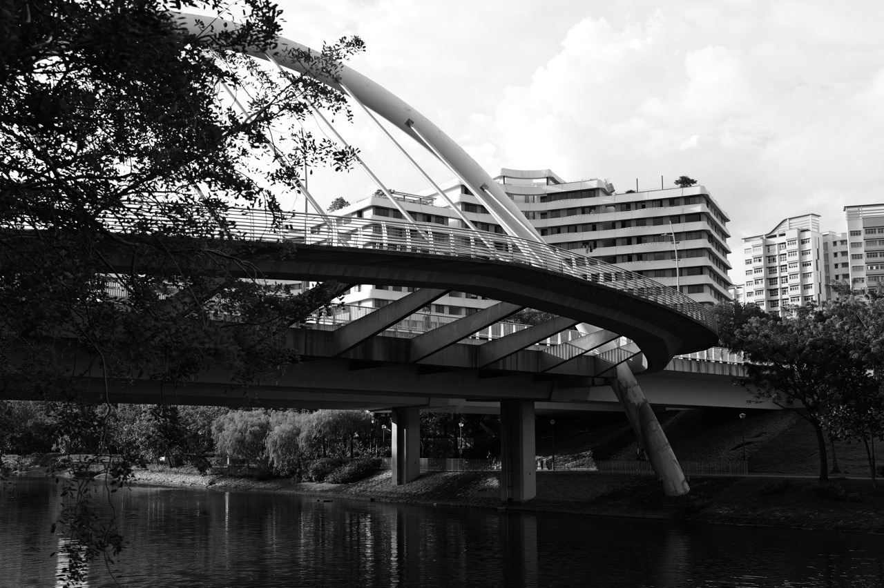
Why does Kelong Bridge at Punggol Waterway Park resemble a traditional fishing platform on wooden stilts, rather than look like an ordinary concrete pedestrian crossing? The design is a deliberate reminder of the old Punggol coastline, where fishing villages, offshore structures and a working waterfront formed part of local life before the modern HDB town. The bridge carries today’s pedestrians, but its shape helps them recognise a much older chapter of the place they are crossing.
The National Parks Board says Kelong Bridge was designed to resemble a kelong, an offshore fishing platform constructed on wooden stilts, and places it among the heritage features of Punggol Waterway Park. HDB’s Explorer Trail says the bridge’s stilts-and-posts wooden design elements recall Punggol’s fishing-village roots. The site forms part of the Heritage Zone, near a preserved old Punggol Road bus stop and 160 metres of the old road. These are documented interpretations of history in a new public landscape, not evidence that the footbridge is an original fishing kelong or that fishing is permitted on it today.
- Where: Kelong Bridge, one of the named pedestrian bridges in Punggol Waterway Park’s Heritage Zone.
- Why it looks different: stilts-and-posts motifs refer to traditional offshore fishing structures and Punggol’s former fishing settlements.
- Actual use: a modern pedestrian bridge and historical landscape feature, not an operating fish farm or fishing platform.
- Nearby history: old Punggol Road’s preserved 160-metre section and former-style bus stop reinforce the area’s heritage interpretation.
- Larger route: the planned and progressively developed Punggol Heritage Trail links the Waterway area towards Punggol Point.
- Different bridges: Jewel, Wave, Sunrise and Adventure bridges use other names and design inspirations.
- Important safety: do not fish where NParks prohibits it, climb railings or enter the Waterway.
- Best sources: NParks’ current Punggol Waterway Park guide and HDB’s Explorer Trail and 2024 Town Design Guide.
Why a bridge can tell a historical story
A pedestrian bridge must first provide a safe crossing over a defined route or waterbody. Its railing, approach and structure serve practical needs.
But public architecture can also express ideas about the place. Kelong Bridge borrows shapes associated with offshore fishing platforms so the crossing is recognisable as part of Punggol’s local history.
This gives one object two legitimate purposes: functional connectivity and historical interpretation. The symbolic purpose does not replace the engineering requirements of a bridge.
What a kelong actually was
A kelong is a traditional offshore fishing structure built on piles or stilts, commonly associated with coastal fishing in Singapore and the region.
It can include platforms and supporting posts above the water, used for appropriate fishing-related activities. Traditional examples belonged to a working economic environment, not simply scenic tourism.
Kelong Bridge adopts visual elements inspired by that structure. It is not a functioning kelong and should not be used or described as a place for raising or catching fish.
Why Punggol has fishing-village heritage
Punggol was historically associated with rural villages, farming, fishing and coastal recreation. Its waterfront supported livelihoods as well as food and leisure.
HDB’s town history identifies fishing villages among the features of older Punggol, while NParks explicitly connects Kelong Bridge’s form to that past.
The history matters because the present-day skyline of HDB flats, LRT tracks and shopping centres does not show all the activities that preceded them. The bridge offers a visual reminder without turning the modern town into a museum.
Why wooden stilts are such a recognisable motif
Traditional kelongs used repeated posts rising from the water and supporting platforms above. Their long slender elements create a distinctive shape.
HDB describes Kelong Bridge’s design as using wooden elements resembling posts and stilts. A person can recognise the visual reference even without having visited a historic fishing settlement.
The motif communicates an idea about older waterfront structures. It does not establish the material composition of every hidden part of the modern bridge or its complete structural design.
Why the modern crossing is not a preserved artefact
An artefact is an object surviving from an earlier historical period. Kelong Bridge was built as part of the modern Punggol Waterway Park development and designed to resemble the older structures.
That verb matters. An architectural reference is not the same as a restored original fishing platform.
A good history explanation can value the design without inventing a heritage status or claiming that fishermen used the present bridge decades ago. Accurate interpretation begins by distinguishing new representations from surviving objects.
Why it belongs in the Heritage Zone

NParks describes Punggol Waterway Park as having several themed areas, including the Heritage Zone. Kelong Bridge sits within the heritage interpretation of the landscape.
The setting helps connect the bridge’s form with other local reminders such as old Punggol Road and the preserved bus stop.
A themed zone is not a fenced area where nothing modern may exist. It is part of a contemporary public park whose design highlights a particular relationship with the past.
Why a heritage trail benefits from multiple clues
One bridge might spark curiosity, but a short walk connecting more than one landmark gives visitors a clearer understanding of the wider story.
HDB’s Explorer Trail links Kelong Bridge with an old bus stop and preserved road segment. NParks identifies these as features that evoke Punggol’s earlier rural and coastal life.
The combination supports interpretation through real public spaces rather than expecting a visitor to understand a complete local history from one architectural motif.
Why old Punggol Road matters beside the bridge
Old Punggol Road once helped connect agricultural and fishing communities with other places. It was part of daily transport before the town acquired its current roads and rail network.
HDB and NParks document the preservation of a short section of the old road near the Waterway Park Heritage Zone.
The modern bridge and historic route have different relationships with the past: one interprets a fishing platform, and the other preserves part of a former transport alignment. That difference makes the pair educational.
Why 160 metres should not be described as the entire old road
NParks states that 160 metres of the former Punggol Road were preserved within the park, alongside an old bus stop.
This is the length of a specific retained section, not a claim that the whole historical road was only 160 metres long.
Being precise about scale prevents an otherwise helpful heritage statement from becoming false. A fragment can be valuable evidence of a route that once extended much farther.
Why the old bus stop is a different form of preservation
The old bus stop provides a recognizable example of transport infrastructure from an earlier period. It was retained to recall the route used by residents and visitors.
Unlike the new Kelong Bridge’s historic inspiration, the bus stop and road segment are described by NParks as preserved features of the older landscape.
This helps students distinguish preservation, reconstruction and symbolic design. Each can contribute to heritage understanding while involving different kinds of authenticity.
Why a new bridge can improve walking connections
Even with a historic theme, Kelong Bridge remains a pedestrian crossing within the Waterway Park route network.
It links parts of a landscaped environment that would otherwise require a different route around the water. Connections matter because people need practical access to parks, homes and amenities.
The historic appearance is an added layer. A bridge that tells a story but cannot be used safely as designed would not meet its public purpose.
Why a footbridge should not be confused with a roadway
Kelong Bridge is described as a pedestrian bridge in the Waterway Park context. Its design and operating restrictions differ from ordinary vehicle roads.
A child should not assume that a crossing big enough to see across the Waterway is open to cars or that scooters and bicycles may use it in any manner without checking signs.
The correct response is to follow the current path classification and local park rules. A bridge’s material or name does not determine all permitted activities.
Why the crossing has to be structurally sound
A public bridge has to carry relevant loads and meet appropriate safety, accessibility and maintenance requirements. Its historic styling does not remove those obligations.
Railings, decking, support and connections remain matters for qualified design and inspection.
It would be misleading to claim that the bridge is structurally identical to a historic wooden fish platform merely because the visible details look similar. Modern engineering and historic reference operate on different levels.
Why an illustrated kelong is not a construction drawing
A stylised drawing may show posts beneath a platform to help a child recognise the design inspiration.
It will not include every structural member, load calculation or material specification needed to build a safe pedestrian bridge.
Students should use heritage images to study the idea and professional documentation for real engineering claims. A familiar visual analogy is not a substitute for certified design.
Why the water underneath is freshwater
Punggol Waterway is part of the freshwater reservoir network connecting Punggol and Serangoon reservoirs. It is not an open tidal fishing platform in the Johor Strait.
The bridge refers to old maritime fishing structures, but the present crossing sits over an engineered urban waterway.
This distinction matters because historical coastal uses and present water-management functions differ. The design theme does not make the current Waterway suitable for saltwater fish farming or unrestricted fishing.
Why a reservoir waterway is managed infrastructure
Punggol Waterway helps connect reservoirs while also forming a major public landscape with park paths and bridges.
Water quality, permitted activities and safety are regulated under current arrangements, regardless of the historical inspiration of the bridge above.
A resident should not equate scenic water with a public swimming pool or fishing ground. Engineering infrastructure can support recreation while still requiring specific rules.
Why NParks prohibits fishing in the park
NParks’ current Punggol Waterway Park information states that fishing is not allowed in the park.
This is particularly important when discussing a bridge named after a fishing structure. The name tells a heritage story; it does not grant an exemption to park rules.
Families should teach children to separate the original historical function of a kelong from the present permitted activities at Kelong Bridge.
Why the bridge does not need a working fish farm
A heritage feature can represent a past activity without recreating all of its commercial or environmental conditions.
The Waterway’s principal present functions include public space and managed freshwater infrastructure, while the bridge recalls an older way of life through design.
The correct historical value lies in interpretation, not forcing a fishery to operate in a site that was not designed or authorised for it.
Why several Waterway bridges have different identities
Punggol Waterway Park has named bridges including Jewel, Kelong, Wave, Sunrise and Adventure bridges.
NParks describes different inspirations or visual characters for each. Jewel Bridge has a dome-shaped structure, while Kelong Bridge draws from fishing platforms.
The variation helps people recognise different parts of the Waterway instead of treating every crossing as an identical anonymous piece of infrastructure.
Why Jewel Bridge is not another kelong
Jewel Bridge takes its name from a domed form reminiscent of a jewel. Its location helps mark a different part of the Waterway landscape.
Kelong Bridge, by contrast, uses the motif of a traditional fishing structure. These are separate design ideas.
A bridge-hunting itinerary may visit both, but an architecture explanation should identify each origin accurately rather than copy one heritage story to every named crossing.
Why Wave Bridge and Sunrise Bridge are distinct
Wave Bridge references the undulating character of the landscape, while Sunrise Bridge is associated with eastern views and the rising sun.
These names help visitors interpret different geographical or design features. A bridge can be recognisable through form, location or intended experience.
The names are not proof that every visitor will see a sunrise or that the weather and views remain unchanged at all times.
Why Adventure Bridge has a different structural appearance
NParks describes Adventure Bridge as resembling a wooden suspension bridge while its actual structure is engineered for present-day public use.
Its reference creates a different walking experience from Kelong Bridge’s fishing-platform motif.
The lesson is that architectural inspiration and modern material or structural systems can coexist. Resemblance is not technical identity.
Why a historic motif can help navigation
A bridge with a distinctive shape and name can become a landmark. People may use it as a reference when describing a route or meeting place.
This is a practical benefit of differentiated design, although it does not replace accurate maps and signs.
A family should still use the correct name and an agreed meeting point, since several bridges span the same broader Waterway and routes can change with maintenance.
Why symbolic design can support place identity
A large new town may contain many similar-looking residential developments. Public spaces can help residents recognise a particular area through distinctive landmarks.
HDB’s town design guidance emphasises fostering a sense of place through local history and landscape.
Kelong Bridge illustrates that approach in a small but visible way: a modern public structure incorporates an image associated with Punggol’s earlier identity.
Why modernisation should not erase every reminder of the past
Building a new town requires new housing, transport, utilities and public amenities. Much of the old landscape changes.
Preserved fragments and deliberate heritage design can help later generations understand what existed before, without preventing the present community from using modern infrastructure.
The bridge’s role is educational and cultural as well as functional. It allows history to remain legible in a transformed place.
Why an architect might use a metaphor
A metaphor in architecture uses a familiar form to suggest another object or idea. Kelong Bridge’s posts and stilts evoke traditional fishery structures.
Such a metaphor can communicate a place’s history quickly without requiring a long sign beside every detail.
But it can also cause misunderstanding when viewers take resemblance literally. A good explanation states both the inspiration and the difference between the modern bridge and the historical structure.
Why wooden-looking details should not be overinterpreted
HDB describes wooden design elements associated with Kelong Bridge’s stilts and posts. That supports a description of the visible design language.
It does not justify inventing the species of timber, the age of every part, an exact pile depth or the bridge’s full structural material schedule.
A technically honest article can explain the intended appearance without pretending to have inspected hidden members or structural plans.
Why a 2010s bridge can still express older history
An object built recently can be designed to communicate the appearance or memory of a much older activity.
That does not make the original period irrelevant. The visual reference works only because people can connect it to documented local history.
The article should identify the bridge as a modern design with historical inspiration rather than misdate it to the time when fishermen built kelongs in nearby coastal waters.
Why the old bus stop provides a useful contrast
The historic bus stop reminds visitors of Punggol’s road transport while the bridge recalls fishing livelihoods.
These two forms of heritage belong to different daily activities in the older rural district. Together they broaden the story beyond one romantic image of the coast.
A visitor can ask what people caught, carried, sold and travelled for, while recognising that the available public displays provide only part of a much longer local history.
Why preserving a short road segment matters
A road route may become difficult to imagine after later building works change its alignment and surrounding uses.
Keeping a short section gives people a physical reference point for understanding the old journey towards the coast.
Kelong Bridge adds a different visual clue about what that journey served. The two can be connected in a heritage walk without claiming they have the same original age or purpose.
Why the Punggol Heritage Trail is a larger project
HDB’s 2024 Town Design Guide describes a heritage corridor based on Old Punggol Road, with a longer 1.3-kilometre trail planned and developed progressively.
The existing Waterway Park segment includes Kelong Bridge and preserved features, while other sections may have separate development schedules or access conditions.
A guide should not promise that every stage is already complete and uninterrupted in November 2026 without current official confirmation.
Why future sections need dated status checks
Plans for a connected trail can change with surrounding developments, construction and public access arrangements.
A drawing in a 2024 town design guide communicates the intended future relationship. It is not necessarily today’s walking map.
Residents should follow current NParks and site notices for an actual visit. Historical design information and live route availability are related but different.
Why Kelong Bridge belongs to the Waterway’s Heritage Zone
NParks identifies four major themed areas of Punggol Waterway Park: Nature Cove, Recreation Zone, Heritage Zone and Green Gallery.
The Heritage Zone helps concentrate reminders of older Punggol in a part of the modern landscape.
The zone is not a formal claim that every nearby tree or pathway dates back centuries. It is a planned public-space theme combining old and new features.
Why the Green Gallery tells another part of the story
NParks highlights mature trees and other landscape features elsewhere along the Waterway, including trees associated with older settlement activity.
This helps visitors understand that heritage can also be found in living vegetation and landscape remnants, not only in buildings.
Kelong Bridge remains a specific architectural reference to fishing culture. A complete heritage walk can include different kinds of evidence without treating them as interchangeable.
Why a bridge can be a good teaching location
Children can observe the physical structure, name and surrounding Waterway in one place. This makes it easier to connect a public object with a historical idea.
A teacher might ask what the posts resemble and what evidence would be needed to determine whether the bridge was a real historic fishing platform.
The answer should refer to NParks and HDB’s official descriptions rather than imaginative guesses from appearance alone.
Why a photograph does not tell the full story
A photo may show railings or repeating posts. It cannot independently establish why architects selected the form or what historical reference they intended.
The official park and HDB descriptions supply that interpretation. A photograph complements them by recording the current visible object.
A useful caption therefore separates observation—posts and platform-like details—from the sourced explanation that the design references Punggol’s fishing-village past.
Why an old postcard may show a different kelong
Historical kelongs varied according to location and function, and a particular archival photograph may show a different structure from the one used as broad inspiration for the modern bridge.
It would be inaccurate to declare that Kelong Bridge is an exact replica of one named old platform without project-specific evidence.
The supported description is that it resembles a traditional kelong through its posts-and-stilts form.
Why fishing heritage is not only nostalgia
Punggol’s older economic life involved people producing food, transporting goods and building livelihoods in a coastal environment.
Remembering that work can help students understand why the old road and waterfront mattered to earlier communities.
The bridge is a starting point for discussion of local economic and social history rather than proof that the past was always idyllic or without difficulty.
Why the word idyllic needs balance
HDB’s Explorer Trail uses language recalling the idyllic mood of Punggol’s fishing villages. That describes the atmosphere the design aims to evoke.
Historical fishing also involved labour, uncertainty, weather and practical risks. An educational article should recognise the people and work behind the romantic image.
A bridge can celebrate a past landscape while readers remain aware that a working village was more complicated than a scenic silhouette.
Why a kelong and a modern reservoir have different safety issues
Traditional kelongs operated in coastal waters under their own working conditions. The Punggol Waterway is now a managed urban freshwater environment.
Visitors need to follow current park restrictions around fishing, entering the water and use of bridges.
Using a historic motif should not lead to unsafe imitation of fishing-platform activities on the modern pedestrian crossing.
Why this is different from the bridge network’s transport purpose
The earlier Why Punggol | Bridges Matter for Walking Across the Waterway examines why crossings provide connectivity.
This article focuses on why one particular bridge looks like a kelong and how its design communicates local historical memory.
The two functions are complementary: a crossing can help people reach destinations while also serving as a landmark that explains a place’s identity.
Why this is different from the old-road history
The Old Punggol Road history article covers the preserved route and its role in connecting earlier settlements.
Kelong Bridge is a later, deliberately themed structure using elements associated with offshore fishing.
Separating their histories allows a reader to understand both without incorrectly treating a modern bridge as part of the preserved road fabric.
Why architecture can make history accessible
Not everybody will read a long historical archive before taking a family walk. A recognisable bridge can encourage a short question about an unfamiliar term.
A parent might explain what a kelong was, then show the child a reliable historical illustration or park sign.
That is a useful educational outcome when the explanation remains grounded. The bridge is a prompt for inquiry, not a substitute for documented history.
Why the park’s heritage features need maintenance
A pedestrian bridge has surfaces, railings and structural components that require appropriate inspection and upkeep. Heritage styling does not make those responsibilities disappear.
Public pathways and historic features also require suitable access and safety management.
A resident who sees a defect should report its location through the appropriate agency instead of attempting a repair or climbing on decorative elements.
Why a historical landmark can change appearance
Paint, vegetation, lighting and the surrounding park can change over time through maintenance and growth. Temporary works may alter access routes.
The bridge’s historic inspiration remains documented even if one image differs from another taken several years later.
A reliable guide distinguishes the design purpose from current condition and uses a dated photograph or official notice when making a present-day statement.
Why a family should not treat all bridge names as directions
Kelong, Jewel, Wave and Sunrise bridges are distinct structures within the Waterway. A meeting point described only as “the heritage bridge” could be ambiguous.
For a real visit, use the exact bridge name and an appropriate current map.
This is a practical English communication lesson: a landmark helps wayfinding only when both people identify the same location.
A fictional history-source exercise
A student observes Kelong Bridge and writes that it was built by fishermen a century ago. The teacher asks for evidence of its date and original function.
NParks describes it as a modern bridge designed to resemble a kelong. The claim must therefore be corrected.
This demonstrates how official interpretation can prevent an attractive story from becoming false local history.
A fictional bridge design comparison
Draw one simple utilitarian pedestrian crossing and another with post-and-stilt-inspired visual features. Both need suitable structural performance and safe pedestrian routes.
Ask what extra information the themed design may communicate to a visitor.
The exercise shows how a modern object can fulfil a practical task and carry a local cultural reference without pretending to be an original artefact.
A fictional map task
Students locate Kelong Bridge within the Heritage Zone, then mark the preserved Old Punggol Road section and nearby bus stop.
They explain how the features provide more than one kind of connection to Punggol’s past.
The map remains a conceptual learning aid, not a guarantee that every future segment of the longer heritage trail is already open.
A fictional material mistake
A child sees wood-like posts and concludes the entire bridge must be made solely of traditional timber piles.
The teacher distinguishes visible design elements from the engineering materials of hidden structural components.
The student learns that a resemblance is not a technical specification. A reliable construction statement would require appropriate project records.
A fictional safety question
A visitor says the bridge has a fishing-themed name, so fishing from it must be allowed. Another visitor checks NParks’ current rules.
The park information says fishing is not allowed.
The students explain why a name and historical inspiration do not override present operating rules.
A fictional local-history interview
A family speaks with an older relative about memories of Punggol’s coastal life. The adult recalls a place name that sounds familiar but cannot remember the precise date.
The student records the recollection as a personal memory and checks public sources before reporting it as a historical fact.
This respects oral history while distinguishing lived recollection from verified event chronology.
A fictional sketching task
An architecture student sketches the bridge’s repeated posts and the way the walkway crosses the water. The drawing records visible form rather than hidden engineering details.
Next, the student labels the documented kelong inspiration using NParks’ description.
The result combines observation and sourced interpretation without inventing the exact timber species, foundation design or original fishing owner.
Teaching Guide: a bridge that crosses water and remembers fishing
Learning goal: distinguish practical bridge function, modern architectural interpretation and genuine preserved heritage.
Activity one: look at a verified public photograph of Kelong Bridge and describe the visible posts and platform-like features.
Activity two: use NParks’ definition to explain what a traditional kelong was. Activity three: compare the words “resembles,” “recreates” and “preserves” and identify which is supported for this bridge.
Activity four: locate the bridge, preserved road and old bus stop on an authorised park map. Activity five: discuss why the modern freshwater Waterway has different rules from historic coastal fisheries.
Activity six: compare Kelong Bridge with Jewel, Wave and Sunrise bridges. Transfer test: examine another modern building inspired by a historic object and identify evidence needed to describe it accurately.
Frequently asked questions
Where is Kelong Bridge? In the Heritage Zone of Punggol Waterway Park.
Why is it called Kelong Bridge? Its design refers to a traditional offshore fishing platform built on wooden stilts.
Was it an actual historic fish farm? No. It is a modern pedestrian bridge inspired by kelong structures.
Why use the fishing theme? To acknowledge Punggol’s former fishing villages and coastal livelihoods.
What other heritage features are nearby? The preserved Old Punggol Road bus stop and a 160-metre section of the former road.
Can visitors fish from the bridge? No. NParks’ Waterway Park rules prohibit fishing.
Is the Waterway seawater? It is a managed freshwater link between Punggol and Serangoon reservoirs.
Is the entire Punggol Heritage Trail complete? Check the current official route; the trail has been planned and delivered progressively.
Are all Waterway bridges kelong-inspired? No. Different bridges have different names and design references.
Where can I verify the inspiration? NParks’ Punggol Waterway Park page and HDB’s Explorer Trail.
Your next step
For the design reference, use NParks’ Punggol Waterway Park guide and HDB’s Explorer Trail. For the heritage-corridor context, consult HDB’s Punggol Town Design Guide (2024).
The Waterway Bridge-Hunting Guide handles the outing. Why Old Punggol Road Still Matters covers the preserved transport route. This article explains why a new pedestrian bridge borrows visual ideas from Punggol’s earlier fishing platforms.
The one idea to remember is that Kelong Bridge performs a present-day crossing while its post-and-stilt design recalls a working waterfront that has largely disappeared from the modern town. The historical story is most valuable when we distinguish a new symbolic structure from the real surviving traces nearby.


