
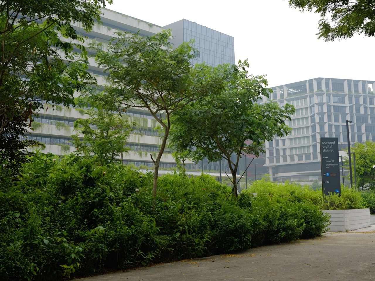
Why does Punggol Digital District have an “inverted skyline” instead of a conventional collection of isolated office towers? JTC’s official 2026 design account explains that WOHA Architects developed a building arrangement with broader upper roof areas and a canopy-like layer above connected public spaces. The idea is to use the vertical shape of buildings to make better room for solar collection, greenery, shelter and public life in a dense tropical district. In other words, the skyline is part of the environmental design, not merely a futuristic appearance.
The design belongs to a district that combines the Singapore Institute of Technology campus, JTC business parks and community amenities. In a traditional high-rise skyline, many separated tower tops can provide a fragmented roofscape. PDD’s distinctive form seeks more usable upper surfaces while retaining people-oriented connections below. JTC describes this as reversing the familiar rising “bar graph” of separate towers. URA’s urban design guidelines add requirements around rooftop greenery, screened technical equipment, landscape replacement and coordinated pedestrian routes. None of these statements means the buildings are physically upside down or that every rooftop is open to visitors.
- Where: Punggol Digital District in northern Punggol, integrating SIT and JTC’s business-park developments.
- Design term: “inverted skyline” or “inverted massing,” documented by JTC and the Centre for Liveable Cities.
- Architect: WOHA Architects for the relevant district architecture and masterplanning.
- Why: broad upper roof surfaces, opportunities for solar collection, greener roofscapes and sheltered, connected public areas.
- Complementary design: car-lite servicing below public levels and building forms shaped with environmental simulations.
- Important limits: roof canopies are engineered building elements, not public walkways by default; projected environmental savings are not guaranteed household results.
- Best sources: JTC’s design blueprint, URA’s PDD guidelines and WOHA’s project account.
Why urban skylines are not only about visual style
A skyline changes how a district is seen from a distance, but building form also determines where sunlight falls, how much roof area is available and how different public spaces relate to one another.
An architect cannot choose a tower silhouette solely to create an attractive photograph. The design must also satisfy structural, environmental, building-service and functional requirements.
Punggol Digital District is useful because JTC explicitly links its upper building geometry to environmental and public-space objectives. The appearance is part of a larger system, not a decorative shape added after every other decision was made.
What JTC means by an inverted skyline
JTC describes a departure from the typical rising “bar graph” of separate towers. WOHA’s scheme introduces a broad, connected rooftop canopy layer hovering over portions of the pedestrian and green environment below.
The word inverted is an urban-design description of how building mass and roof area are organised. It does not mean the whole building hangs unsupported from its roof, or that a conventional skyscraper has literally been turned upside down.
The useful explanation is geometric: the upper areas can spread differently from an arrangement of narrow isolated tower tops, changing the relationship between roof area and the public spaces below.
Why comparing cross-sections is more useful than memorising a label
A front photograph shows a skyline in one direction. A building section shows how floors, roof layers and ground-level spaces fit vertically.
Draw a conventional simplified tower with a narrow top and compare it with a conceptual form that offers a broader upper canopy. Ask where solar panels, planting and pedestrian shelter might fit under each arrangement.
This does not prove the actual PDD geometry or its engineering dimensions. It helps students understand why changing a building’s shape can change the space available for other functions.
Why broad rooftops can support solar collection
Solar photovoltaic panels require suitable surface area, exposure and safe installation conditions. A collection of small, fragmented roofs may offer different opportunities from a broad planned roofscape.
JTC says the inverted massing helps maximise roof areas for renewable-energy collection. That is a design intention supported by the published architectural explanation.
The actual power generated depends on the number and specification of panels, sunlight, shading, electrical connections and operating conditions. A larger-looking roof does not automatically generate a precisely known quantity of electricity without equipment and measurements.
Why solar roof area is not the same as solar output
Area is measured in square metres. Installed solar capacity is expressed in units such as kilowatt-peak or megawatt-peak. Electrical energy generated over time is measured in kilowatt-hours or megawatt-hours.
These quantities are related but not interchangeable. A rooftop might have plenty of space while technical equipment, access routes or shading limit where panels can be placed.
A strong article should not convert a panoramic photograph into a claim that the district produces a certain amount of electricity every hour. The relevant forecasts and observed generation need their own sources and measurement periods.
Why JTC’s 3,000 MWh figure needs context
JTC’s sustainability page describes planned rooftop solar generation of approximately 3,000 megawatt-hours annually at the relevant project scale.
That is a forecast or project estimate for electricity over a year, not a constant output rating and not evidence that every individual roof contributes equally.
Students can learn to attach the unit and time period to the claim. If the source says expected annual energy, an article should not rewrite it as measured instantaneous power. The value of the architectural form can be explained without exaggerating what the figure proves.
Why a roof is also needed for building services
A commercial or institutional building may require mechanical equipment, access, maintenance pathways and other technical systems at or near roof level.
URA’s urban design guidelines for PDD require such service areas and equipment to be integrated into the building envelope and visually screened, rather than treated as exposed afterthoughts.
This creates an important design trade-off. The roof can support renewable energy or greenery only within the needs of structural safety, servicing and appropriate maintenance. Not every square metre becomes freely available just because the skyline looks broad.
Why roof gardens and roof farms are different uses

A roof garden may provide vegetation, landscape or community space. An urban farm aims to produce food or other crops under appropriate management. Solar panels generate electricity. These functions need different equipment and operating arrangements.
JTC’s PDD sustainability programme identifies rooftop urban farms and solar canopies among its features. The presence of the concepts does not mean every roof is an unrestricted garden or that every planned farm is open to public harvesting.
The better explanation identifies the mechanism and responsible operator for each use instead of calling every green-looking rooftop the same technology.
Why the upper surfaces can help the public environment below
A broad upper layer may provide shelter or shade to selected public areas below, depending on geometry and the sun’s position. This can make a route more comfortable in Singapore’s climate.
JTC describes the canopy layer as hovering above connected public spaces and preserved greenery. The idea is to give people space to walk and gather while building mass is organised above and around them.
A roof that covers one part of a route does not guarantee the whole district remains shaded, dry or cool every hour. Actual comfort still depends on weather, wind and local exposure.
Why shade depends on the sun’s position
The direction and height of the sun change through the day. A structure casts a shadow whose position and length vary with those conditions.
A canopy that shades a plaza at noon may not shade an adjacent walking path in the late afternoon. Building orientation, nearby structures and the dimensions of the roof influence the result.
For students, a simple paper model with a movable torch can illustrate the relationship. That model is not a certified daylight study for PDD, but it helps explain why architects use simulations instead of relying only on one attractive rendering.
Why natural light and solar heat must be balanced
A building and public space need suitable daylight, yet excessive direct sunlight can create unwanted heat and glare. Maximising sunlight everywhere is not the same as maximising comfort.
JTC says advanced simulations were used to shape PDD’s buildings for natural light, reduced solar heat and airflow.
That is a design trade-off. Some spaces benefit from more daylight; others need shelter or glare control. The best form responds to intended use and climate rather than follow a universal rule that every window or walkway should face the sun.
Why cooling demand can be influenced by architecture
Heat entering a building can contribute to its cooling needs. Orientation, external shading, building envelope design and internal uses all influence the relevant conditions.
PDD combines passive design measures with a district cooling utility. These are different parts of the overall thermal system: architecture can reduce unwanted heat gains, while cooling infrastructure removes heat that still needs to be managed.
It would be inaccurate to claim that an inverted roof makes air-conditioning unnecessary or guarantees one precise energy saving for every connected building. A full evaluation needs actual performance data and defined comparisons.
Why PDD’s roofscape must look coherent from nearby buildings
A roof visible from other towers becomes part of the district’s visual environment. Mechanical equipment, water tanks and poorly coordinated installations can make a roofscape unattractive or cluttered.
URA’s guidelines explicitly require technical rooftop services to be screened and integrated within the building design.
This requirement illustrates why roof planning is not only a matter of engineering performance. The roof is also part of the public-facing urban landscape, even when ordinary visitors cannot stand on it.
Why landscape replacement is part of the rulebook
URA’s PDD urban design guidelines require landscape replacement areas equivalent to 100% of the site area on relevant development parcels, through sky terraces, roof gardens and suitable landscaping arrangements.
This is a planning requirement, not proof that one continuous rooftop forest has already been planted on every building or that all landscaping consists of native habitat.
A student should distinguish a design condition from an observed environmental outcome. The requirement creates space and opportunity for greenery; ecological performance still depends on actual planting, species, care and surrounding conditions.
Why the word ‘replacement’ does not mean restoring an identical forest
An urban design rule may require landscape area to compensate for development within a site. That does not mean every plant, soil condition and ecological relationship from the original terrain has been recreated.
A roof garden and a mature natural forest differ in rooting conditions, habitat continuity and maintenance. Both can have value, but they are not interchangeable.
The responsible language is that the guidelines require substantial landscaping provision and aim to make the built district greener. A claim about biodiversity equivalence would require specialist ecological evidence rather than an area percentage alone.
Why roof greenery requires structural engineering
Plants, growing media and retained water add weight. Roof spaces also need drainage, waterproofing, access and maintenance.
A mature tree requires different support and rooting volume from low-growing planting. A solar canopy has its own structural and electrical requirements.
The geometry that creates rooftop opportunities therefore creates technical responsibilities. A broad roof is useful only when its design can safely support the intended functions. Visitors should never access restricted roofs or install planting without authorisation.
Why the inverted form can accommodate public spaces below
JTC’s description places connected public spaces and greenery beneath or alongside the broad upper forms. Rather than leaving every ground-level area to vehicles and service functions, the design aims to make pedestrian movement central.
That relationship connects the rooftop geometry with the district’s street life. The structure above and routes below are planned together.
But this does not make every place under a building a public plaza. Retail, business, campus and service premises have their own access rules. The relevant public routes must be identified through actual signs and maps.
Why the underground service network is a complementary decision
PDD also places parking, heavy servicing and selected technical infrastructure beneath the pedestrian public realm. This helps prevent vehicle operations from dominating some of the spaces framed by the architecture above.
The upper rooftop form and lower service network solve different parts of the spatial problem. One expands possibilities for roof and sheltered public space; the other organises vehicle and technical functions.
The separate PDD underground servicing article explains that lower-layer mechanism. The present article owns the question of why the building silhouette and rooftop surfaces look different from a conventional skyline.
Why a district needs more than decorative greenery
Plants can influence shade, visual comfort and habitat opportunities, but the choice of species and the long-term management of the landscape are important.
JTC’s sustainability plan includes preserved greenery and connections to Punggol’s wider landscape. URA’s guidelines also refer to retaining the site’s sense of topography and natural character.
The correct lesson is that landscape design should work with the living environment. A green surface in a rendering cannot prove that the same ecological conditions will persist for decades. Actual maintenance and monitoring matter.
Why preserving old trees matters in a new district
A new university and business park might appear to require clearing everything and building from a blank slate. PDD’s design guidance instead emphasises considering existing natural features.
JTC’s programme includes a 1.3-kilometre Heritage Trail with conserved trees, connecting the new development with elements of the area’s earlier landscape.
That is related to the inverted skyline but not identical. Architectural form, landscape retention and heritage interpretation are complementary ways to shape a place, each with its own evidence and operating conditions.
Why the district does not have to look like a line of towers
A conventional financial district may have separate tall office towers with relatively small roof footprints. PDD’s mixed-use approach explores another relationship between building mass, roof area and the public realm.
That does not establish that a traditional skyline is always inferior. Different sites, densities, planning controls and structural requirements can justify different forms.
The useful claim is local and specific: WOHA’s PDD design deliberately uses inverted massing to address its identified environmental and spatial objectives. Other cities should evaluate whether similar methods suit their own conditions.
Why geometry can affect pedestrian scale
A tall building can feel imposing when a person stands beside a large uninterrupted façade. Architects may use setbacks, terraces, canopies and public-space proportions to shape how a building is experienced at ground level.
PDD’s design includes broad roof forms and connected public spaces below, giving the district a different visual character from a field of disconnected towers.
But one person’s sense of openness is not an objective airflow measurement. A full assessment of pedestrian comfort requires actual conditions and the relevant design criteria.
Why a canopy can be good for some weather but not every kind
Overhead cover may reduce direct solar exposure or shelter parts of a route from ordinary rain. In a tropical city, both functions can support daily usability.
However, wind-driven rain may reach underneath an edge, and a building canopy is not a universal guarantee of lightning safety.
A visitor should follow current weather warnings and seek appropriate shelter during severe conditions. Describing the design as people-friendly does not change the physical hazards associated with storms and exposed public spaces.
Why rooftops are not automatically community parks
A large roof visible from the street may be part of a technical installation, solar array, landscape system or restricted building facility.
A person should not assume that a rooftop garden shown in an artist’s rendering is open for casual visits or public photography. Access rules depend on the actual development.
The distinction matters for truthful local reporting. Architectural provision can create a useful environmental asset even when that particular roof is not a recreational destination.
Why the architect’s stated concept matters
WOHA’s project page describes PDD as Singapore’s first Enterprise District, bringing together a business park, university, community facilities and transport in one integrated masterplan.
The design team aimed to support a green, connected and inclusive environment. JTC’s later sustainability explanation gives additional detail about the roof and public-space approach.
Using the architect’s and developer’s descriptions together helps avoid assigning imaginative motives to every visual shape. A reader may personally interpret the buildings, but a factual design article needs a documented concept.
Why ‘built’ and ‘fully occupied’ are different
WOHA’s project account identifies completion of its building and masterplan work by late 2024, and JTC’s district has opened progressively across its different components.
A completed building form does not mean every tenant, solar installation, garden or public programme has necessarily reached its eventual operating stage.
This is important for any 2026 description. The visible skyline may be substantially complete while parts of the district continue to develop. Exact access and operational status should be confirmed from current official sources.
Why the skyline works with a car-lite district
Placing vehicles and heavy servicing below important public areas creates more opportunity for the pedestrian environment envisioned by the upper architecture.
The result is a planned vertical relationship: some technical and vehicle functions below, connected human activity at public levels, and selected environmental uses on roofs.
The important lesson is that a design decision can reinforce another without performing the same job. A solar canopy does not itself manage car parking, and a basement does not generate solar power.
Why the project is not a template for every HDB block
PDD consists primarily of university and business-park development with its own land-use and engineering requirements. HDB residential blocks serve different needs and are built under different projects.
A household should not assume its nearby flat has an inverted skyline or the same rooftop equipment just because both places share the name Punggol.
A genuine local explainer should identify the development boundary and building type. Similar environmental principles may be relevant across projects, but exact design features do not transfer automatically.
Why visual green buildings need measured outcomes
A building may appear lush with plants, yet its environmental performance depends on factors such as energy use, cooling loads, material impacts and actual maintenance.
PDD has published design expectations and sustainability features. Those provide a credible account of the intended approach, but an environmental audit of realised outcomes would need appropriate operational records.
The correct approach is neither to dismiss the design nor to declare it perfect from photographs. State the intended mechanism, the evidence available and what would still need measurement.
Why the roof can influence the shape of public routes
A broad canopy may frame certain walking paths and help connect nearby buildings through a more sheltered public environment.
URA’s guidelines identify the importance of walkable and cycling-friendly connections across the district. The architectural form is therefore considered in relation to movement, not only energy collection.
Yet a roof overhead does not replace route signage, step-free access or maintenance. A public route must still be usable by actual people, including those with mobility needs and those visiting the district for the first time.
Why passive design complements smart software
JTC’s Open Digital Platform integrates information from selected district systems, helping manage operational conditions. Architecture instead shapes the physical environment before a control system acts.
Passive measures such as shading and suitable building form can reduce some unwanted environmental loads. Digital systems can provide information and coordinate suitable operations under authorised rules.
The two are complementary. Software cannot move a concrete roof after construction, and a roof alone cannot analyse a cooling system’s performance. Good district design combines physical and digital decisions without confusing them.
Why the roof is not itself a battery
A solar panel generates electricity when useful sunlight reaches it. A battery stores previously supplied electrical energy under appropriate conditions.
The roof provides a place for equipment; its geometry does not make it an electrical storage device. PDD’s separate smart grid combines solar generation and battery storage with digital demand management.
The PDD solar-and-battery article explains that energy-system relationship. The present question is about the architectural space made available for solar collection and public uses.
Why the public might not notice the inverted skyline
People usually navigate by entrances, shops, signs and visible walkways. The district-scale roof geometry may be easier to understand from an elevated photograph, architectural model or section drawing.
A visitor standing under a canopy sees only part of the form, so the entire concept may not be immediately obvious.
This is why explanatory diagrams matter. A photograph provides a particular view; a plan or section helps reveal relationships that are difficult to see from the ground. None should be treated as a substitute for current access information.
A fictional comparison of rooftop area
Imagine a simplified group of buildings with five separate roof areas of 400 square metres each. Together they provide 2,000 square metres, before deductions for services or unsuitable zones.
Now imagine a different form whose upper structure provides a broad 3,000-square-metre canopy. The hypothetical model has more gross roof area, but that does not prove it supports 50% more solar output.
The usable PV area still depends on the technical requirements. These figures are invented to explain geometry, not measurements of PDD.
A fictional sunlight problem
A student builds two cardboard structures: a narrow tower and a wider upper canopy. They use a torch to explore how shadows change as the light position moves.
The observation may show different shaded shapes in the model. It does not establish real temperature, annual solar energy or structural suitability.
The lesson is to identify what the demonstration measures: geometry of light and shadow under simplified assumptions. Real architectural simulation requires more detailed information.
A fictional roof-allocation exercise
Give students a hypothetical roof with 100 area units. Reserve some units for equipment and safe access, others for planting and the remainder for suitable solar panels.
The student discovers that each use competes for limited space even on a broad upper surface. A realistic design must allocate the roof rather than declare every square metre available for multiple incompatible purposes.
This teaches constraints, arithmetic and the difference between a desirable objective and a technically feasible arrangement.
A fictional green-replacement claim
A learner reads URA’s 100% landscape replacement requirement and concludes that the district has an identical forest to the one that existed before building work.
The teacher asks whether equal area proves equal species, soil or ecological relationships. It does not.
The corrected statement is that the design guidelines require a substantial landscaping equivalent in area under defined rules. Whether the realised ecological outcomes are equivalent would need different evidence.
A fictional visitor misunderstanding
A visitor sees an elevated planted roof and tries to find a staircase up to it. There is no public-access sign.
The correct response is not to enter a service staircase or follow an employee through a restricted door. The visitor should use designated public routes and ask the operator if a guided or authorised visit is available.
The lesson is that a visually public green feature and a physically public recreational space are not always the same.
How students should read an architectural rendering
A rendering can communicate a design concept clearly, especially the relationship between upper forms and public spaces. It may also include illustrative vegetation, people and future conditions.
Students should label it as a rendering and distinguish it from a dated photograph or technical drawing. The intended design and the actual operating condition can differ.
A strong research answer may combine the architect’s concept, the developer’s official description and a current photograph without claiming they prove exactly the same fact.
Why the visual identity matters to Punggol
Punggol has developed from earlier rural and coastal landscapes into a new town with housing, education and industry. The Digital District’s architecture contributes another recognisable layer of that development.
The inverted skyline signals a different approach to high-density construction, one that explicitly connects rooftop environmental opportunities with the public realm below.
But a distinctive silhouette is not sufficient by itself to make a good community. The everyday value depends on public access, service reliability, maintenance and whether the intended environmental measures actually perform as planned.
Teaching Guide: invert a skyline without losing the town
Learning goal: explain why PDD’s architectural form seeks broader roof areas and a different relationship with public spaces, then distinguish design intentions from measured results.
Activity one: draw a conventional rising tower skyline and PDD’s conceptual inverted roofscape. Activity two: label suitable roof uses, public spaces and building services. Activity three: explore how hypothetical sun positions change the shapes of shadows.
Activity four: calculate invented gross roof areas, then deduct access and equipment allocations before estimating any space available for solar panels. Activity five: compare URA’s landscape replacement rule with a claim about actual biodiversity; explain why they are not equivalent.
Activity six: add the underground service network, then identify which jobs are performed by architecture, vehicle infrastructure, solar panels and digital controls. Activity seven: practise citing a developer’s design statement without presenting a future estimate as measured performance.
Transfer test: propose a different roof arrangement for a fictional campus, explaining what local conditions, building functions and measurements would be needed to assess it.
Frequently asked questions
What is PDD’s inverted skyline? JTC’s term for WOHA’s broad upper canopy-like massing, designed as an alternative to a conventional rising collection of towers.
Who designed the architecture? WOHA Architects is credited with PDD’s inverted skyline concept in JTC’s account.
Why build broad rooftop areas? To create more appropriate opportunities for solar, greenery and environmental design while integrating the public realm below.
Are the buildings physically upside down? No. The term describes their urban massing and skyline concept.
Can visitors walk on every roof? No. Public access must be authorised for the particular space.
Does the roof replace all building air-conditioning? No. Passive design and the district cooling system perform different complementary functions.
What does 100% landscape replacement mean? A URA design requirement concerning equivalent landscape area under the stated rules, not proof of identical restored natural ecology.
Does rooftop solar deliver constant power? No. Output changes with sunlight, equipment and conditions.
Is PDD the same development as Punggol Northshore HDB? No. They are different projects and have different uses and design details.
Where can I read the design explanation? JTC’s sustainable district blueprint, URA’s PDD guidelines and WOHA’s project page.
Your next step
A Punggol resident can look at an authorised exterior view of the Digital District and identify three separate layers: the upper roofscape, the public walking spaces and the technical or servicing infrastructure described in the official plans.
For reliable primary information, consult JTC’s PDD sustainable development blueprint, URA’s PDD urban design guidelines, WOHA’s project page and JTC’s sustainability features.
For the physical underground functions, read Why Punggol | Digital District Puts Vehicle Servicing Beneath Public Streets. For electrical operation, see Why Punggol | Digital District Combines Solar Power With Battery Storage.
The central idea is that PDD’s skyline is engineered to create useful upper and lower spaces. A different-looking roof makes sense only when its benefits, constraints and actual performance are understood as part of the whole district.


