
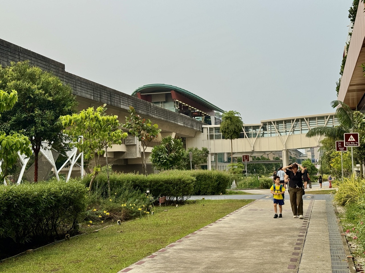
Quick answer: A covered walkway in Punggol is not automatically a step-free route, and a step-free route is not necessarily sheltered for its entire length. The useful journey is a continuous chain: flat or arrival point → usable lift or ramp → safe pedestrian path → crossing or bridge → correct building entrance → destination. One staircase, blocked linkway or inaccessible doorway can break that chain. A reliable route must be checked at the level where people actually walk.

Punggol looks easy to navigate from above. Its recognisable waterway cuts across town, rail viaducts create strong landmarks, neighbourhoods carry memorable names, and many pedestrian routes run beside parks, malls and housing. Then a parent pushes a stroller toward a crossing and finds a short staircase. Or an older relative reaches an elevated connection and discovers the lift they expected is closed for maintenance. Suddenly the shortest line on a map is not the easiest route.
This guide explains Punggol’s sheltered walkways, ramps, ground levels and step-free walking connections for residents, parents, students and visitors. It is about decision-making at street level, not an inventory of every LRT station and not a forecast of the entire future transport network. We use known features of Punggol—HDB precincts, the waterway, Sam Kee, Northshore, and Punggol Digital District—to explain how to read access and avoid mistakes.
The crucial habit is to verify connectivity as a chain rather than collect isolated accessibility labels. A path described as wheelchair friendly may still have an approach from your chosen bus stop that deserves separate checking. A covered corridor may have a dry roof but a sloping or uneven joining surface. A road can split a pleasant walk into two very different sections. Read the whole journey before you decide how much help, time or equipment your family needs.
Five distinctions worth knowing
| Term | What it actually tells you | What it does not guarantee |
|---|---|---|
| Sheltered or covered | There is a roof or canopy over a section | Every metre is protected from wind-driven rain |
| Step-free | A route can be taken without requiring stairs | It is short, flat, cool or always available |
| Wheelchair accessible | A site or route is described as accessible | Every entrance and connection is equivalent |
| Shared path | More than one user group may use the corridor | Pedestrians have a dedicated empty lane |
| Elevated link | Connection passes at another level | A working lift is available at every approach |
Start with the hidden access problem
Most directions tell you where to go, not what your journey demands of your body or equipment. A navigation app can identify a path between two points and still omit a temporary barrier, a narrow turn, a lift outage, a steep approach or a section that is exposed to afternoon rain. People who walk unaided may hardly notice these details. People using wheelchairs, prams, walking frames or heavy shopping trolleys cannot afford to ignore them.
The best route is therefore not always the shortest route. It is the shortest reliable route that fits the traveller. A family with a sleeping baby may willingly walk farther to avoid a staircase. A person recovering from injury may prefer a shaded path with seating to a more direct path that has no place to rest. A student carrying musical equipment may find that a ramp matters more than two minutes of travel time.
Punggol gives these questions a real setting. Its residential walkways, park connectors, rail access points and the developing digital district form different parts of the pedestrian network. The names may all appear on the same neighbourhood map, but each part can have its own managing body, signage, operating hours and temporary conditions. Think of the journey as a series of physical connections that must all work.
1. Choose the starting point and destination precisely
Many walking instructions begin with ‘from Punggol’. That phrase is too vague for practical accessibility. A town is not a single front door. Even one block can have different exits, lifts, car-park access points, service roads and ramps. A correct route needs an origin more precise than a neighbourhood name and a destination more precise than a mall logo or school name. Think in terms of an exact entrance, lift lobby or bus-stop side.
Take a journey to One Punggol as an example. The useful destination is not merely ‘the community hub’. It might be the library entrance, a specific lift, the hawker centre or a meeting point under the large roof. The final vertical connection can differ depending on where the journey ends. Two relatives reaching the same building from different directions may need different accessible approaches even though the address is identical.
Write a route as a sentence: ‘Start at the ground-floor lift lobby of Block X, use the sheltered path toward the marked crossing, remain on the pedestrian path, and enter by the ramp-accessible entrance.’ The statement should be verified on site and updated when access changes. It is much easier to check than a casual instruction to ‘follow the LRT’.
A Punggol example
A grandparent and a young child leave home together. The grandparent cannot handle repeated steps; the child wants the shortest way to a playground. The family chooses the entrance closest to a usable ramp, not the entrance nearest the playground on a bird’s-eye map. The journey improves because the requirement was stated before the route was chosen.
2. Treat stairs, slopes and level changes as different problems
A staircase is an obvious break in a step-free route. Slopes are subtler. A ramp avoids steps, but a long or steep slope can be tiring, difficult to control with a loaded pram, or unsuitable for some wheelchair users. The absence of a visible staircase is therefore not enough. Look at the route’s gradient, turns, landings, surface and how much effort the traveller must sustain.
Punggol has visible differences in ground levels around roads, bridges, parks and major developments. A path may reach a higher pedestrian deck while the road underneath remains at a lower level. In a photograph these may look close together. For somebody who cannot use stairs, the correct route might circle to a ramp or lift before reaching the same deck. The vertical distance matters even when the horizontal distance looks tiny.
Singapore planning guidelines often specify dimensions and gradients for particular types of development. They are design requirements, not statements that every old path is identical. At Punggol Digital District, URA’s current guidance describes different platform levels for covered and elevated links and requires step-free integration with ramps. A family should still verify completed public access and current conditions before relying on any proposed connection.
A Punggol example
A stroller user stands below an attractive elevated viewing area. There is a staircase five metres away and a ramp whose entrance is on the other side of a building. The actual accessible walking distance is set by the ramp network, not by the five metres visible between the user’s position and the deck.
3. A roof does not make a route weatherproof
Covered walkways are valuable in Singapore’s climate, especially on the trip to a bus stop, market or school. But a canopy has edges, open sides and joining points. Wind-driven rain can enter under a roof; strong sunlight can come from the side at some times of day; and a narrow gap between two covered sections can leave a traveller exposed. ‘Sheltered’ is a useful design description, not a promise that a person will remain completely dry.
The transition points deserve attention. Walkways often end at a pedestrian crossing, a car park, a building forecourt or the boundary of a public park. These are locations where the traveller may need to stop, wait or change direction. In heavy rain, the largest inconvenience may be the uncovered crossing rather than the long stretch of roof behind it. A reliable journey considers where a stroller can pause without blocking others.
Shade varies with the hour. A beautiful tree-lined path may offer good morning relief but less protection when the sun reaches a different angle. Greenery can improve comfort, yet the level of shade at a specific bench changes. The sensible observation is time-stamped: ‘This section was shaded at 9 a.m. on the day we visited.’ Do not turn one observation into a claim that the route is always cool or dry.
A Punggol example
A family plans to bring an older relative to lunch at Northshore Plaza. The map shows a covered approach near the estate, but the final crossing is exposed. They keep a compact umbrella, choose a safe stopping point and plan a slower approach. Their route is still worthwhile; it is simply described accurately.
4. Read shared paths as places where people negotiate space
Punggol’s attractive walking and cycling network draws different users into close proximity. A shared path may carry schoolchildren, runners, recreational cyclists, older pedestrians and parents with prams. The path’s appearance alone does not establish every legal rule; follow the current surface markings, signs and applicable Active Mobility regulations. At a busy hour, the effective space available to one person can be much smaller than the path’s total width.
Pedestrians should expect other users to appear, especially at corners, intersections and near entrances. Cyclists should moderate speed and give appropriate consideration to pedestrians. Parents can teach children to avoid sudden sideways movements, particularly when a bicycle is approaching. A person who needs more time to cross the path benefits from a predictable line of travel and a companion who looks both ways at junctions.
A family walking near Sam Kee LRT may experience the viaduct as a strong visual landmark. That does not mean the ground path follows a completely sheltered, isolated or pedestrian-only route. Watch for path symbols, bicycle movements, junctions and blind spots. The public-space etiquette is not complicated: leave passing room, be visible, slow down at conflicts and never force someone with a mobility aid off the route.
A Punggol example
An adult walking beside a child takes the outside position near a shared-path junction and asks the child to look before changing direction. This is not because every passing cyclist is unsafe. It is because predictable movement protects everyone and makes the path usable for slower travellers.
5. Crossings are links in the route, not small interruptions
Walking maps often draw roads as thin lines, but real crossings require timing, attention and space. A traffic light, zebra crossing or pedestrian refuge can determine whether a route is safe and accessible. Never invent a crossing merely because a road separates your location from the destination. Follow the designated facilities, obey the displayed signals and consider how long a traveller needs to cross without rushing.
At a crossing, the approach may be as important as the carriageway. A pram needs a usable kerb ramp. A person with low vision benefits from appropriate tactile and audible guidance where provided. A walking-frame user may need a space to wait without being pushed toward traffic. These requirements make a nearby formal crossing preferable to an unmarked shortcut, even when the shortcut appears to save time.
Temporary construction can change crossings and pedestrian flows. If a familiar crossing is closed or diverted, follow the posted route and inspect its accessibility. Do not assume that a gap in a fence is an unofficial pedestrian shortcut. A ‘just follow me’ instruction is especially risky for children and people who move more slowly.
A Punggol example
Near a shopping-centre entrance, the shortest route crosses a service driveway. A parent pushing a pram uses the designated pedestrian crossing, even though it adds a short detour. That decision is based on vehicle conflict and visibility, not on an arbitrary preference for a longer walk.
6. Know the difference between a bridge and a route over a bridge
Punggol is recognisable for bridges spanning its waterway and various road crossings. A bridge is a structure; the accessible route includes the approach to it, any lift or ramp, the crossing surface and the far-side descent. A scenic bridge can look easy from the water’s edge while requiring a detour to a slope or stairs at one end. Never infer barrier-free access purely from the bridge’s appearance in a postcard.
Some bridges and promenades form part of park networks, while others are linked to commercial or transport developments. Their managers and maintenance procedures can differ. The question is not only ‘Can I get onto the bridge?’ but also ‘Can I leave it on the correct side and continue to the destination?’ When a bridge meets a stepped trail, the whole journey may cease to be step-free at that point.
Assess the direction of travel. A slope that feels manageable downhill may be difficult on the return journey. A path that has a shaded rest stop before a bridge may lack one afterward. For longer trips with older relatives or children, identify a turnaround point before committing to the full circuit. This is a practical form of route design.
A Punggol example
A family admires a bridge over Punggol Waterway. They initially plan to cross and return by another route. At the far bank they discover that the alternative return includes stairs. The correct plan is to retrace the verified bridge approach rather than improvise a potentially inaccessible loop.
7. Lifts are part of the route’s reliability
Lifts make vertical pedestrian connections possible for many users, but they are mechanical systems. A route that depends on a lift should include a question about its current availability, not merely its existence. Scheduled works, faults, temporary closures or building operating hours can change the practical route. If a person cannot use stairs, an unavailable lift may be a complete break rather than a mild inconvenience.
Check the relevant transport operator or building management information where available and look for site notices. There may be another entrance or lift, but do not assume it exists without verifying. For a high-stakes journey, such as a medical appointment or school reporting time, prepare an alternative that remains accessible if one link fails. A taxi drop-off or different station approach may be more reliable than attempting an unknown staircase.
Distinguish a lift at an MRT or LRT station from a lift within a mall or residential development. Even when both connect the same general area, they may have separate maintenance, access rules or hours. A useful accessible itinerary names the lift or entrance and includes a fallback. It does not rely on a vague instruction to ‘take the lift somewhere near the station’.
A Punggol example
A wheelchair user is travelling to Punggol Coast for an appointment. The family checks the intended station entrance and destination access before leaving. When a lift is unavailable, they do not treat an escalator as an equivalent substitute. The fallback route was chosen because it meets the traveller’s actual mobility needs.
8. Rest opportunities can matter more than distance
A path can be perfectly step-free and still be exhausting. Long stretches without seats, shade or toilets may be uncomfortable for older adults, young children and people managing fatigue. A route may also have noisy road frontage or multiple crowded junctions. These practical factors do not negate accessibility labels, but they explain why one route can be more suitable than another for a particular household.
Use a rest-stop method. Identify a starting point, a reachable bench or indoor space, and a destination. Estimate walking in manageable segments rather than a single total. If somebody needs to stop every few minutes, choose a path where stopping does not block cyclists or pedestrians. Prefer real seating over a low wall that may be difficult to stand up from. Check that any planned indoor rest stop is open.
Punggol Waterway Park Connector, for example, is listed by NParks as wheelchair friendly and includes places to sit and enjoy the surroundings. This is useful official context, but the exact distance between your preferred rest points and accessible entrance needs checking on the chosen segment. A park’s total route length tells you very little about whether a specific family can comfortably complete it.
A Punggol example
Two friends decide to walk beside the waterway. One can comfortably walk two kilometres; the other prefers short stretches with seats. Instead of prescribing the full circuit, they choose a short out-and-back from a known entrance and make the first rest stop the decision point for extending the outing.
9. A park connector and an HDB walkway may feel continuous but be managed separately
A person walking from a housing estate toward the waterway may cross land under several forms of management. The sheltered estate link may be HDB common property, a roadside path may be within a transport corridor, and the park connector may be under NParks. The user’s experience is one journey, but repairs, closures and operating conditions can be administered by different organisations.
This matters when a light fails, a pavement is damaged or a tree has fallen. Reporting the exact location helps the correct party respond. A photograph of a defective tile beside a particular block says more than an assertion that ‘the park path is broken’. A route description can identify the point where the covered estate path meets the exposed park connector, helping residents know when their environment and governing signs change.
It also explains why different parts of a walking route may be maintained on different schedules. An accessible map assembled from several networks can become out of date if one section is repaired while another is closed. For urgent hazards use the appropriate on-site or emergency channel; for ordinary municipal faults, OneService can help route an issue whose manager is not obvious.
A Punggol example
A stroller wheel catches on a damaged edge at the transition between a sheltered estate path and a park connector. The parent records the exact location and nearby landmark, rather than guessing which agency owns it. The report can then be assigned based on the asset’s actual boundary.
10. Punggol Digital District has multiple planned walking levels
URA’s updated Punggol Digital District urban design guidance, current as of October 2026, is especially instructive because it describes covered pedestrian networks at different levels. The text distinguishes a road and bus-interchange level from a Campus Boulevard and elevated pedestrian level. It also specifies connections between Teck Lee LRT, the water, buildings and nearby roads, with ramps used to address level differences.
These are planning and design parameters. They show how the district is intended to work, not proof that every indicated link is open to the public today. A future elevated link may be drawn on an urban design plan while construction is continuing. A completed pathway may have a temporary closure. A building may be physically visible while its public through-route has different opening conditions. Do not treat design intent, construction completion and usable access as the same statement.
The enduring lesson is that a two-dimensional map cannot fully describe three-dimensional movement. A path can pass over a road at one level and reach the waterfront at a lower level. Someone using a pram needs to know how the transition happens, not just the two end points. Read platform-level annotations as planning information, then confirm actual entrances and operations when making a journey.
A Punggol example
A student compares a map of Punggol Digital District with a photo taken from the public side of a development. The map indicates a proposed elevated link, while the photo shows a building still being fitted out. The correct report says the link is specified in official design guidance and the public operating status needs confirmation; it does not claim the link is already open.
11. How to read URA’s walkway dimensions without misusing them
URA describes minimum covered walkway dimensions for particular development types. For the Punggol Digital District it specifies at least 3.6 metres for certain all-weather covered routes, and gives separate requirements for through-block links and other pedestrian elements. On its broader commercial walkway page it distinguishes overall width from clear width. Those figures are useful for understanding design intent, not for estimating the compliance of a random walkway from a camera image.
Overall width includes the general span of the constructed walkway; clear width is the unobstructed usable part. A row of columns, furniture or equipment can change how much space pedestrians actually have. A walkway that appears broad in a photograph may narrow near a doorway or temporary display. Accessibility is experienced at the narrowest relevant point in the chosen route, not at the widest part a developer photographed.
Do not carry a single guideline width from one development type into every HDB corridor, park path and commercial footpath. Different rules and approval dates may apply. Residents can use the design concept—continuous, clear and sufficiently wide travel space—without posing as building inspectors. Serious concerns about obstructions or unsafe conditions should be documented and referred to the responsible authority.
A Punggol example
A parent takes a photograph of a covered path beside a mall and wants to claim it ‘violates the 3.6-metre rule’. That conclusion is not justified from a photo. The useful observation is that the route is narrow at a certain point during busy periods, with an exact location and description of the obstacle. The correct technical review belongs to the responsible agency.
12. Choose a waterway route by segment, not just by total length
NParks describes the Punggol Waterway Park Connector as an 8.4-kilometre route and lists it as wheelchair friendly. That can help a family decide whether the area is worth exploring. But the number describes the overall route, not a sensible target for a toddler, someone recovering from surgery or a grandparent who walks slowly. A family plan begins with a suitable segment and known entry point.
Decide whether the outing is a transit walk or a leisure walk. A transit walk values reliable time and direct access; a leisure walk can pause for shade, views and wildlife. Crossing from one side of the waterway to the other may change the required route. A bridge can provide a convenient loop, but a loop must be checked for step-free access and available rest opportunities. The most enjoyable path may also be the one that lets everyone turn back without difficulty.
Re-check the forecast and on-site conditions before a long outdoor walk. Singapore’s heavy rain and strong sun create practical considerations. Carry drinking water and take breaks; avoid flooded or cordoned-off paths. PUB advises pedestrians to avoid flooded areas and move to safety rather than attempt risky water crossings. A route that is normally usable can become unsafe under particular weather conditions.
A Punggol example
A family starts at a convenient waterway entry with a stroller and decides on a 25-minute out-and-back rather than a complete 8.4-kilometre outing. They choose a bench as the turnaround marker, keep to the marked path and return early if rain approaches. This is not a lesser visit; it is a route scaled to the people using it.
13. Punggol Point Walk is an example of declared accessibility
NParks’ Punggol Promenade Punggol Point Walk listing describes a 1.3-kilometre coastal route and identifies it as wheelchair friendly. The page also provides access information near Punggol Point Park and Punggol Road End. This is useful primary-source information when deciding where to bring a visitor who needs a step-free coastal experience. It is far stronger than an unattributed claim that all of Punggol’s seaside trails are equally accessible.
However, ‘wheelchair friendly’ is a route-level description, not a personal guarantee for every approach, weather condition or mobility aid. Check the practical arrival route from the selected bus stop or drop-off, what facilities are operating, the surface after rain and whether any sections are closed. Conditions can vary by date. Do not extrapolate the designation to a nearby unofficial coastal track or private access.
This distinction improves travel writing. Rather than listing a pretty path as simply accessible, a careful guide names the exact officially described segment, its published length and where the reader can confirm access. It acknowledges that the last hundred metres from a particular arrival point may need separate planning. A family gets information they can act on instead of a slogan.
A Punggol example
An older relative would like to see the sea without attempting a long hike. The family consults NParks’ current Punggol Point Walk page, identifies an appropriate arrival method, and chooses a short section with a clear return plan. They do not combine several adjacent nature routes without checking whether the entire combined route is step-free.
14. Temporary closures break a route even when permanent plans are excellent
Construction, maintenance and events can change Punggol’s paths. Temporary hoardings, resurfacing work, lift repairs and pavement barriers can make a familiar route unusable for a while. This does not invalidate a well-designed network; it is a reminder that an actual journey happens at a particular time. A route should be considered ‘usable when checked’, not assumed permanently unchanged.
Follow signed diversions and barriers. Never move a barricade or enter a worksite because the normal path seems shorter. If a diversion includes steps, it may not suit everyone who used the original route. Ask the site operator or relevant authority for the accessible alternative where available. When the situation is urgent or dangerous, use the appropriate safety contact rather than relying on a website article.
Route photographs should be dated and described carefully. A photo of construction works outside Watertown in early October 2026 cannot establish the present location of pedestrian barriers weeks or months later. For readers, the best current evidence is a combination of official notices and on-site signage. For bloggers, distinguishing a past observation from ongoing status is essential.
A Punggol example
A student follows a familiar link toward an LRT station and meets a temporary barrier. The correct response is to follow posted directions, not step into the roadway. If the detour is inaccessible for an accompanying wheelchair user, they stop and find a safe verified alternative rather than improvising through the work area.
15. Plan for school routes as journeys, not simply shortest distances
Parents often focus on travel time when children start a new school. But the route also needs safe crossings, predictable footpaths, visibility, weather protection and a backup when something changes. A child carrying a heavy bag may be tempted to use a faster but unsafe shortcut. The family can reduce this risk by walking the actual route together and explicitly identifying where to slow down, stop and look.
Morning and dismissal periods add a different level of congestion. School gates, bus stops, drop-off points and nearby roads may be busy even if the same space is quiet on a weekend. Teach children to stay out of vehicle driveways, observe signals and use designated pedestrian paths. A route chosen at noon might feel different at 7 a.m. The observation should match the time the child will actually travel.
An especially good exercise is to name three fixed landmarks that cannot be confused with similar-looking blocks. Also establish a safe plan if a path is closed or the child misses a turn. A child should know a trusted place to seek help rather than take an unfamiliar short cut. Good wayfinding is partly spatial knowledge and partly a routine for making safer decisions.
A Punggol example
A Primary school child and parent walk the route to a Punggol school three times: once at a quiet hour, once at the actual morning arrival period and once on a wet day. They may find that the shortest line is less predictable than a slightly longer route with marked crossings and clear landmarks.
16. Accessible walking supports three generations at once
An accessible route is not a narrow specialist concern. A child learning to walk, a parent moving a pram, a delivery worker wheeling equipment and an older adult using a walking frame all benefit from clear paths and well-designed level changes. They may have different speeds and priorities, but the same corridor can support all of them if it is maintained and treated considerately.
Good route planning balances the slowest person’s needs with the group’s purpose. On a family outing, it is usually easier to move together along one reliable route than to split repeatedly between stairs and a distant accessible entrance. Plan where people will rest, where a taxi or bus can be taken, and what to do if someone becomes tired. Avoid turning the family walk into an endurance test.
Equally, do not describe every older adult as needing the same assistance. Ask the person what works for them. A person who uses a cane may prefer fewer slopes even if that means one step-free indoor detour. Someone using a wheelchair may know a preferred entrance with a smoother surface. An effective guide provides choices and verifiable information, not assumptions about capability.
A Punggol example
Three generations plan to visit One Punggol. The grandparent wants a place to sit, the parent needs a pram route and the child hopes to see the library. The family agrees on an entrance that supports all three, chooses a short indoor rest stop and leaves the rest of the afternoon flexible.
17. Check a route with five simple observations
You can test a neighbourhood route without special surveying equipment. First, check continuity: can a person reach the exact destination without unwanted stairs or blocked passages? Second, check safety at crossings: are there designated ways across roads and driveways? Third, check comfort: are there suitable shaded sections and rest places? Fourth, check wayfinding: are the signs and landmarks sufficient at forks? Fifth, check resilience: is there a known alternative if the primary link closes?
Take two or three photographs from public areas, with permission and sensitivity to privacy. Record the date, approximate time and direction of travel. A photograph of a crossing from only one side may conceal an awkward kerb on the far side. A video can also miss a sudden vertical transition. The goal is an accurate short route description, not a dramatic travel reel.
If you are making a guide for others, separate facts from judgement. ‘There is a ramp near this entrance’ can be directly observed. ‘This route is suitable for every wheelchair user’ is a much stronger claim and usually cannot be justified by casual observation. Say what you checked, what you did not and where official information can be found. Readers can then match the route to their own needs.
A Punggol example
A teenager makes a school project map from a local HDB precinct to the waterway. They mark the approved crossings, stairs, ramps, benches and open-ended questions. They note that the route was checked on one afternoon and may change. The result is a civic observation project with a clear evidence standard.
18. Turn walking knowledge into a reusable family plan
Choose one frequent journey, such as home to the nearest LRT station, home to the library or home to a waterfront park. Define a normal route, an accessible alternative and an indoor or sheltered fallback for extreme weather. Save the entrance name and visible landmarks. For a journey involving lifts, include the contact or update source used to check access. Keep the plan short enough for a family member to understand without a map expert beside them.
Next test it under ordinary conditions. Walk it when you have enough time to notice the turns and barriers. Ask the person with the strictest accessibility requirements whether the route actually works for them. Adjust rather than insisting the route is perfect because it looked good on a diagram. Repeat only when conditions or family needs change. A plan is not a guarantee; it is a way to make uncertainty manageable.
Finally, leave room for civic improvement. If a pavement has a clear defect, report it precisely. If a diversion is confusing, describe the missing sign and location. If you discover a better accessible connection, share it with neighbours without overstating its official status. Punggol’s network becomes easier to use when residents combine clear observations with respect for the changing built environment.
A Punggol example
A family prints a simple home-to-station card: use the nearer lift lobby, turn left at the covered path, cross at the marked signal, and use the verified entrance. Underneath is a second option for a temporary closure. The card is far more useful than ‘walk north for seven minutes’, which assumes both perfect conditions and a particular walking speed.
Four practical route tests
A buggy-to-library trip
Begin at the exact residential lift lobby rather than the centre of the block on a map. Inspect the kerb ramp, crossing, shelter gaps and library entrance. Check whether there is a lift to the intended floor. Time is secondary to avoiding an impassable section. An adult who can carry the buggy up steps may still choose the step-free path because it works with a sleeping child and is easier to repeat.
An elder’s short morning walk
Choose a level route with benches, toilets where relevant and an easy turnaround. Observe shade at the intended hour. Avoid promising that a route is cool merely because trees appear in photographs. Prefer a short out-and-back to an unfamiliar loop. If the person’s energy changes, the family can shorten the walk without scrambling to locate a distant road exit.
A new student travelling to Punggol Digital District
Read the current site and station information, not only a future URA plan. The district’s guidance explains its intended multi-level pedestrian network, but a design description and an operating access route are not interchangeable. Identify the exact building entrance and allow for temporary diversions. A student who checks the final link can arrive more reliably than one who assumes every planned skybridge is ready.
A wet-weather park visit
Check the current forecast and PUB flood alerts, choose a safely accessible park entrance and identify an indoor fallback. A covered walkway may protect much of the approach, but the park connector itself can be exposed. Avoid flooded sections, slippery barriers and closed paths. A family that turns back early has made a sound decision, not failed to complete an itinerary.
Frequently asked questions
1. Does a covered walkway mean it is wheelchair accessible?
Not necessarily. A canopy describes shelter. Accessibility depends on continuity, slopes, crossings, clear widths and usable connections.
2. Is a route step-free if it includes a ramp?
It can be, but a ramp’s gradient, surface and landings matter. Inspect the full route and individual traveller needs.
3. Are all Punggol Waterway paths accessible?
NParks officially lists the Punggol Waterway Park Connector as wheelchair friendly. Do not apply that designation automatically to every adjacent trail and entrance.
4. Can I assume a future link on a URA map is open now?
No. Planning requirements, built completion and actual public access are different statuses.
5. How should I plan if a lift is out of service?
Check for a verified alternative suitable for the traveller. Never assume escalators or stairs are equivalent for users who cannot use them.
6. Is the shortest walking route the best route with a stroller?
Often not. A slightly longer step-free route with safe crossings can be much more practical.
7. What changes when it rains?
Wind-driven rain can cross shelter edges, uncovered joins become important and wet or flooded surfaces may be unsafe. Follow PUB safety guidance and turn back from flooded areas.
8. Can children cycle quickly on shared pedestrian paths?
Follow current path rules, signs and markings. Children should be supervised and should slow down near pedestrians, corners and crowded sections.
9. Where should I report a damaged pathway?
Use the operator or responsible agency when known. OneService can route many ordinary municipal issues; give an exact location and photograph.
10. How can I check a route for an older relative?
Ask about the person’s needs, walk the actual approach, identify seats and an accessible return path, and verify any lift or entrance on which the journey depends.
Official sources and where to verify
URA: Punggol Digital District Urban Design Guidelines (updated October 2026)
URA: Open and Covered Public Walkway Design Requirements (June 2026)
NParks: Punggol Waterway Park Connector
NParks: Punggol Promenade Punggol Point Walk
PUB: Flood Safety Tips for Pedestrians and Commuters
Continue through eduKatePunggol
Punggol Wayfinding for Families
Future of Punggol: Campus Boulevard, Covered Walkways and the Car-Lite District
Punggol Green beneath the LRT: Courts, Playgrounds and Sam Kee
Things to Know About Punggol: Void Decks and Shared HDB Spaces
A successful Punggol walking route is not simply a line connecting two famous places. It is a sequence of usable decisions: where to start, how to change level, where to cross, which entrance works and how to respond when a link closes. Once those questions are answered, the town becomes easier to navigate for everyone.


