
On Wednesday, 9 October 1996, the Punggol 21 exhibition was launched at the Raffles City Central Atrium, not at Punggol. Minister for National Development Lim Hng Kiang introduced a proposed waterfront town whose future residents would be offered housing variety, clustered community facilities, pedestrian-friendly spaces, an integrated MRT–LRT network and ambitious leisure plans. The event is preserved in a five-page official National Archives speech delivered at 10.30 am.
This was more than a property show. Visitors were invited to look at a plan for 21st-century life before most of the proposed town existed. The minister asked for public feedback on the ideas. A later Centre for Liveable Cities study records an HDB planner’s recollection that people visiting the atrium asked when they would be able to book homes in Punggol. Those accounts together show that this particular exhibition was both a presentation of a plan and an early moment of public interest.
The historical rule is crucial: a feature promised in 1996 is not automatically a feature completed later. Some proposals were altered, delayed or superseded as the 1997 Asian Financial Crisis changed development conditions and Punggol 21 was later redesigned. This guide follows the exhibition, its precise claims and the difference between what planners envisioned and what residents eventually received.
What this historical guide covers
- What happened on 9 October 1996?
- Why the exhibition was in Raffles City
- From solving a housing shortage to planning a lifestyle
- Five headline features of the original vision
- The proposed housing mix and smaller estates
- Community-facility clusters before integrated hubs
- What ‘car-free’ meant in the 1996 speech
- The 300-metre LRT aspiration
- Two commercial centres and a leisure-oriented coast
- Coney Island and the proposed 50-hectare regional park
- What a planner later remembered about visitor interest
- The crisis that changed the development sequence
- From Punggol 21 to Punggol 21 Plus
- A date-by-date guide to avoiding mix-ups
- Five research questions for students
- Frequently asked questions about the 1996 exhibition
- The original documents and the historical conclusion
What happened on 9 October 1996?
The speech heading identifies the occasion as the launch of the Punggol 21 exhibition at Raffles City Central Atrium, with Lim Hng Kiang speaking as Minister for National Development. That is a specific public event, not an undated drawing produced somewhere in a planning office.
The invitation at the end of the speech was straightforward: Singaporeans could visit the exhibition to examine the new-town ideas and provide feedback. It shows that public presentation and consultation were built into the launch rhetoric. It does not provide a complete count of visitors, the precise format of each display or a published dataset of every comment submitted.
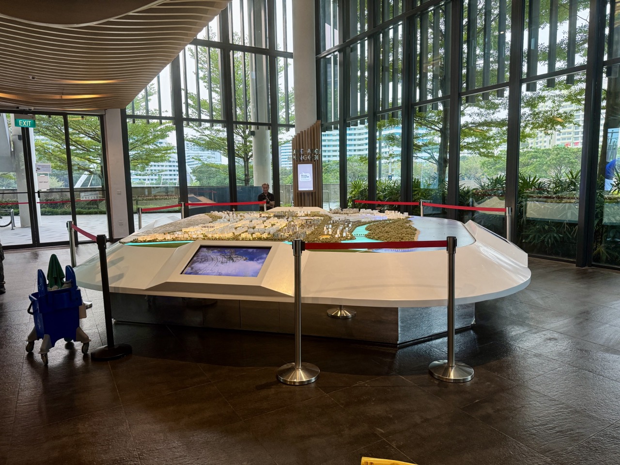
If you are writing a caption, use the full phrase ‘Punggol 21 exhibition, Raffles City Central Atrium, 9 October 1996’. Avoid describing an image of today’s Punggol model as an original photograph of that event.
Why the exhibition was in Raffles City
Punggol 21 was a proposal for a future residential town. Raffles City offered a central urban setting in which people from across Singapore could examine the idea before they had any reason to visit an unfinished construction site. This is a reasonable reading of the exhibition’s public-facing purpose; the original speech does not separately state why this particular building was selected.
The distinction between venue and subject is one of the most easily lost facts in online summaries. Punggol was the subject, Raffles City was the site of the public launch. A family photograph taken at the exhibition would therefore show a city-centre setting rather than an already completed Punggol waterway precinct.
A later Centre for Liveable Cities book, Punggol: From Farmland to Smart Eco-Town, independently identifies the 1996 exhibition as an HDB–URA presentation at Raffles City. It includes the perspective of a planner who recalled visitors asking about future flat bookings.
From solving a housing shortage to planning a lifestyle
The minister organised his speech around the evolution of public housing. He referred to the initial need to provide shelter quickly after the Housing and Development Board was established in 1960, followed by home ownership, construction quality and improvements to older estates.
He then framed Punggol 21 as an additional objective for the next century: housing should sit within a wider environment where people could live actively, travel conveniently, gather socially and enjoy recreation. The message was not that Singapore had stopped needing homes, but that successful housing policy now had to consider how people lived outside their flats.
This distinction is useful for students studying public policy. Provision of shelter is a fundamental outcome; environmental quality, time spent travelling, leisure choices and social ties are further aspects of everyday well-being. The 1996 proposal tried to show how those goals could be combined in a purpose-built town.
Five headline features of the original vision
The 1996 speech named five main elements. First was a mixture of public and private housing. Second was clusters of community facilities. Third was a car-free living environment in the neighbourhood sense described by the minister. Fourth was an integrated transport system. Fifth was a varied set of recreational amenities.
These are features of the 1996 vision. The speech tells us what planners were proposing; it does not certify that every element existed by a stated completion date. Comparing the five principles with subsequent buildings and transport services requires a separate development timeline and more recent records.
Read the five together and a pattern emerges. Punggol 21 was being presented as a system of homes, routes, communal facilities and recreation rather than simply a group of residential towers. How those pieces interacted mattered as much as the list itself.
The proposed housing mix and smaller estates
Homebuyers were to have choices among public housing, executive condominiums and private housing. The minister also referred to smaller HDB estates with roughly 1,200 to 2,800 units, intended to encourage neighbourhood bonds and distinct styles.
It would be inaccurate to infer that every later HDB project in Punggol contained that number of homes. The figures belong to the design language of 1996. Projects built in different years responded to evolving population, land availability and planning considerations.
For an educational exercise, compare ‘number of homes in an estate’ with ‘number of residents who know neighbours’. The first is measurable from project plans; the second needs social evidence. The speech expressed the aspiration that neighbourhood scale could foster connection, not a proven formula converting homes into friendships.
Community-facility clusters before integrated hubs
The speech proposed community-facilities clusters serving local residents with schools, libraries, clubs and communal amenities. Rather than scattering every service without a relationship to the others, planners envisaged clusters as neighbourhood centres of activity.
This theme now seems familiar to people using integrated facilities in the wider town. But the 1996 wording should not be treated as a contemporaneous description of a facility that opened decades later. A vision can anticipate a planning principle without supplying the final building’s name, operator or opening year.
For related but later evidence, read the One Punggol community hub history. Keep the original 1996 proposal and modern completion records in separate columns.
What ‘car-free’ meant in the 1996 speech
One intriguing feature was the idea of a pedestrian-friendly neighbourhood green, created in part through the way car parks would be arranged. The minister’s stated ambition was to give residents communal open space that did not have cars moving through it in the ordinary way.
It does not follow that the entire 1996 town plan contained no roads or parking. ‘Car-free living environment’ referred to a particular kind of residential experience in the explanation, not a legal ban on vehicles across all of Punggol. Reading the surrounding paragraphs protects against an exaggerated modern headline.
In the classroom, sketch three spaces: a vehicular road, a sheltered walking connection and a communal green. Ask which movements intersect and which can be separated. That simple diagram captures why the minister treated pedestrian life as a planning question, not just decoration.
The 300-metre LRT aspiration
The speech envisioned MRT access to the city and LRT circulation around Punggol. One distinctive promise was that residents would not need to walk more than 300 metres to an LRT station, with sheltered links also intended for movement toward trains and buses.
That distance is a 1996 planning promise, not a verified rule applying to every household in 2026. To establish present-day walking distances, a researcher must use current street layouts, station entrances and actual safe walking routes, rather than calculate a straight-line circle from an old exhibition.
A comparison chart could show proposal, project implementation and current experience separately. Such a chart helps explain how transport planning is tested over time, especially in a town that took years to develop and whose LRT stations opened in phases.
Two commercial centres and a leisure-oriented coast
The minister envisaged two commercial centres, six to eight recreational clubs, a waterfront promenade and two marinas. These details gave the proposed town a distinctive identity in 1996. The water was to be part of everyday living, not just a boundary at Singapore’s northeast edge.
The quantities must be cited carefully. They were announced ambitions. It would be misleading to claim that Punggol later opened exactly eight clubs and two marinas as a consequence of the exhibition unless separate opening evidence supported it. Some specific plans were revised in later stages of development.
The desire for water-based leisure did have historical roots. Punggol’s older coast had fishing communities, boatels, recreational boating and seafood destinations. The 1996 planners were not inventing every element of the coastal lifestyle from nothing, even though the physical form of a new town would be very different.
Coney Island and the proposed 50-hectare regional park
The 1996 account included the prospect of crossing to Coney Island and enjoying a 50-hectare regional park with leisure facilities including chalets, clubs, sea sports and camping. The proposal was bold because the island offered a visible natural landmark around which planners could describe a future recreational geography.
This description must not be copied as a current amenities list. A proposal for chalets in the 1990s does not prove there are bookable chalets at Coney Island now. The island’s eventual public park and nature-conservation arrangements followed later decisions and should be assessed against actual NParks guidance.
For readers of history, the 50-hectare proposal illustrates a tension between recreational intensity and landscape stewardship. Punggol’s subsequent development increasingly incorporated ecological aims as well as waterfront access. Those later priorities should be dated as separate chapters.
What a planner later remembered about visitor interest
The Centre for Liveable Cities study includes Seow’s recollection of people coming to the Raffles City exhibition and asking when they could book Punggol homes. It is a useful retrospective account because it records a participant’s impression of the mood around the proposed town.
The recollection is not an attendance database or representative opinion survey. It supports a narrower statement: at least some visitors expressed serious interest in future housing. It does not prove every household wanted to move, or that initial excitement would translate directly into sales at the time construction began.
This makes the exhibition a good example of how historians combine source types. The October 1996 speech establishes the official proposal; an interview included in a later planning study supplies remembered public reaction. The two complement one another while answering different questions.
The crisis that changed the development sequence
The CLC historical study documents how the 1997 Asian Financial Crisis reduced housing demand and slowed Punggol’s development. It also describes the early 2000s as a period in which fewer facilities and limited transport services made the completed environment fall short of the original excitement.
The contrast is a powerful planning lesson. A compelling exhibition can describe what should eventually be built, but actual implementation depends on economic conditions, housing demand, infrastructure sequencing and many actors working over years. A resident who moved in early could experience a very different Punggol from the artist’s impression.
That does not make the original exhibition a fraud or every ambition meaningless. It shows that the date of a plan and the date of its delivery are two different historical facts. Any discussion of success must choose a proper time frame.
From Punggol 21 to Punggol 21 Plus
Punggol 21’s difficult early years set the stage for later revision. In 2007, the government’s Punggol 21 Plus vision introduced a major new feature: an inland man-made waterway connecting the river systems and bringing waterfront space further into the town.
The later waterway is often the first image people associate with Punggol. It would be wrong to place its completed bridges, park design and 2011 opening inside a 1996 exhibition photograph. The concept of waterfront living was present in 1996, but the inland waterway and subsequent detailed design were later steps.
For the chronology, see Punggol 21, Punggol 21 Plus and the town’s second draft and the 1998 planning report. Those are companion histories, not substitutes for the 1996 launch record.
A date-by-date guide to avoiding mix-ups
1996: Punggol 21 vision unveiled and exhibition launched at Raffles City Central Atrium on 9 October. 1997–98: Asian Financial Crisis disrupts development momentum. 1998: early development activity and planning milestones continue. 2001: official opening of the young Punggol 21 town. 2003: Punggol MRT and bus interchange open. 2005: passenger LRT services begin. 2007: Punggol 21 Plus announced. 2011: the Punggol Waterway opens.
This timeline comes from the official speeches and CLC’s later reconstruction. It must not be read as an uninterrupted sequence of completed 1996 exhibition promises. The changing pace and revision of the vision are central to understanding why residents encountered a town under construction for many years.
The phrase ‘Punggol 21 opening’ can refer to more than one historical moment: proposal unveiling, exhibition launch and the 2001 official town opening. Always attach the date and event label.
Five research questions for students
First, which statements in the October 1996 speech describe something already achieved in Singapore’s housing programme, and which describe future Punggol plans? Underline the verb tense. Second, why might the original design offer different housing categories? Third, what would make a community-facility cluster convenient or inconvenient?
Fourth, how should a historian test the claim that all residents would be within 300 metres of an LRT station? A current map may help describe 2026 conditions but cannot establish what was constructed in 1996. Fifth, why can an exhibition attract public interest while a later housing development still slow down?
These tasks help primary and secondary readers combine language, mathematics, geography, economics and history. The most useful lesson is evidential: a promise, a retrospective memory and a measured outcome are not interchangeable.
Frequently asked questions about the 1996 exhibition
Was the Punggol 21 exhibition held in Punggol? No. The documented launch was at Raffles City Central Atrium. When? 9 October 1996. Who delivered the launch speech? Lim Hng Kiang, then Minister for National Development. Was Punggol Waterway already built? No; the inland waterway is associated with subsequent planning and opened in 2011.
Did the speech mention the LRT? Yes, along with integrated MRT access, shelters and a 300-metre walking aspiration. Did it propose two marinas? Yes, as part of the vision. Does that mean two were eventually delivered? The original speech alone cannot establish that. Did the organisers ask for feedback? Yes, visitors were publicly invited to respond to the plans.
Was the 1996 launch the same as the 2001 official opening? No. They are separate milestones. Why did development slow? Later government-backed research identifies the impact of the Asian Financial Crisis and the resulting changes in housing demand.
The original documents and the historical conclusion
Read the 9 October 1996 Punggol 21 exhibition launch speech for the minister’s original five-part vision, the stated distances and quantities, and the invitation for public feedback. Compare it with the Centre for Liveable Cities’ Punggol: From Farmland to Smart Eco-Town for retrospective interviews, the exhibition’s response and the financial-crisis disruption.
Then use the Punggol history directory to follow the town from village landscape through planning, transport and the completed waterway. The exhibition’s real historical value was that it allowed people to inspect and imagine a new town before they could inhabit it. That makes 9 October 1996 a milestone in the history of expectations—not a licence to label every subsequent Punggol landmark ‘built in 1996’.
Photo note: The featured photograph is a 2026 image of a contemporary Punggol town scale model. It illustrates urban planning and is not an archival photograph of the October 1996 Raffles City exhibition or of its original display model.


