
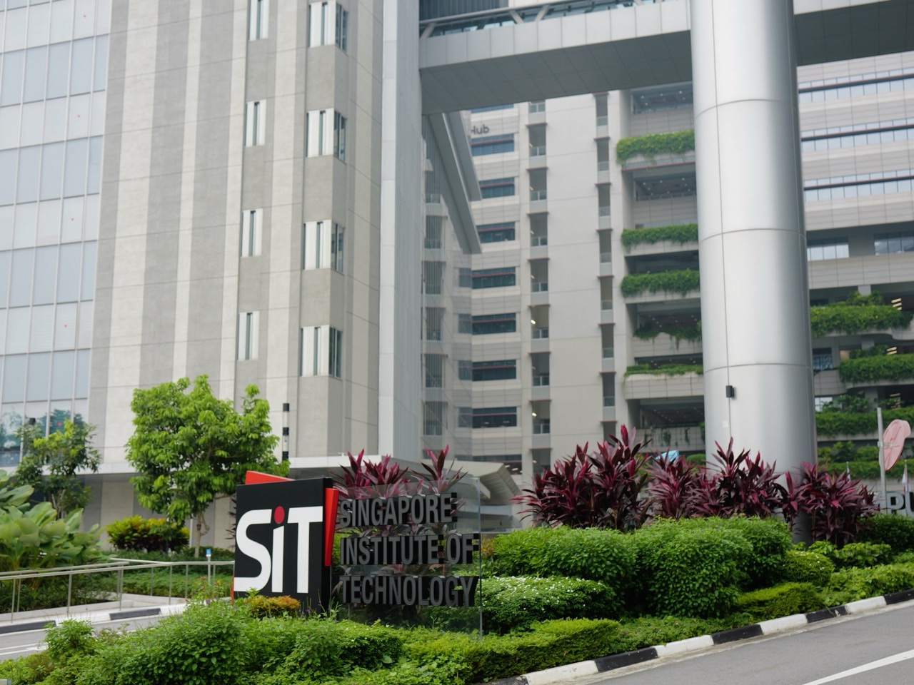
Future buildings at Punggol Digital District will be judged against more than their height or commercial floor area. URA’s current 2026 design guidelines protect space for public parks, low-rise waterfront pavilions, retained Casuarina trees, shaded movement and accessible gathering areas. Understanding those requirements reveals what the future of Punggol’s coast is meant to look and feel like.

The direct answer: what URA’s current PDD guidelines require
Updated 23 October 2026. URA’s Punggol Digital District Urban Design Guidelines, most recently marked as updated on 20 October 2026, describe how future and continuing developments within the district should fit into a pedestrian-friendly, waterfront, green and accessible urban environment. The rules include height limits for waterfront pavilions, requirements for publicly usable open space, building landscaping, walking and cycling connections and the treatment of mature trees. The page’s update date is not proof that all of its design provisions were introduced for the first time that day.
A particularly distinctive requirement applies to the Market Village waterfront frontage: within the specified waterfront depth, URA describes a maximum single-storey form, with smaller pavilions integrated among existing Casuarina trees. Elsewhere along parts of the waterfront, other low-rise limits apply. URA also specifies at least 1.8 hectares for Campus Heart, a minimum 4,000-square-metre Nexus, a minimum 3,000-square-metre Promenade Plaza and a minimum 1,000-square-metre Boulevard Plaza. These are planning requirements, not a notice that all spaces are operating in their final form.
Why does this matter to people who live in Punggol? Because the district’s future should not be judged only by the number of offices or the height of buildings. A waterfront can be made inaccessible by continuous walls, heat and awkward level changes even when the architecture looks impressive. URA’s design framework attempts to keep the area porous, green, publicly connected and appropriate to the town’s coastal landscape.
Design guidelines are not the same as a construction opening notice
Urban design guidelines establish requirements and expectations that apply to planning and development proposals. They are different from an occupancy permit, a completed building inspection or a public event calendar. A resident reading a rule for a shaded plaza should not assume the plaza is already furnished, accessible and open at all hours. That status must be checked separately.
Likewise, a drawing of waterfront pavilions explains the intended form of development; it does not identify the final restaurant tenant, prices, opening hours or whether a particular space can be booked. The design can shape how the area evolves without settling every commercial decision.
This distinction is central to sound local reporting. A future-plan article should explain what the competent agency is asking developers to provide. A visitor guide should explain what people can actually enter today. Combining them without dates can produce an attractive but misleading story.
What is Punggol Digital District’s planning purpose?
The district combines JTC’s business park with Singapore Institute of Technology’s campus. URA describes it as a place for digital and cybersecurity industries, applied education and engagement with the wider community. The intention is to connect work, learning and ordinary public life in a compact environment rather than create a fenced business park separated entirely from nearby residents.
Its setting includes an existing water edge, undulating topography and mature vegetation. Those features distinguish it from a conventional flat commercial parcel. URA’s guidelines explicitly call for design that responds to the landscape and protects the district’s rustic charm, even as new buildings introduce very modern technology.
The planning challenge is to reconcile these ambitions. A dense employment district needs usable floor space and logistics; a university needs learning spaces; residents need paths and places to gather; vegetation needs room to survive. The built environment is successful when all of these functions can coexist without forcing everyday users through confusing or hostile spaces.
Why URA wants a permeable district rather than a wall of towers
URA says developments should avoid creating a wall-like effect, especially along the Heritage Trail, waterfront and New Punggol Road. The intended buildings should be visually and physically porous, with smaller-scale articulation and openings that allow people and views through the precinct. A row of massive uninterrupted blocks can feel impenetrable, even where there is plenty of green space behind it.
Permeability describes the ability of people, movement and often visual connection to pass through the urban fabric. It does not mean access to private offices or secure laboratories. A public path can run between buildings while their interiors remain appropriately controlled. Good design makes that distinction clear through legitimate entrances, signage and unobstructed public routes.
A resident can evaluate the idea from a lawful public viewpoint. Can they see through the district to another public space? Are entrances legible? Does the route force an unnecessary detour? These questions are more useful than simply deciding whether a building looks modern or expensive.
The one-storey Market Village waterfront rule
In the specified Market Village frontage along the waterfront promenade, URA describes buildings limited to a maximum of one storey within a depth of up to 50 metres. The intent is to keep the waterside scale intimate and retain the existing Casuarina trees. Rather than one continuous large facade, the guideline envisages a series of discrete buildings or pavilions integrated with the landscape.
That is a meaningful urban-design choice. Restaurants and leisure spaces can attract activity, but tall walls close to the water may block views and reduce the sense of a shared waterfront. Lower pavilions with spaces between them can create opportunities for shade, airflow and a more human-scale setting. Whether a particular proposal achieves that balance requires review of the actual detailed design.
The rule should not be converted into an announcement that a certain number of restaurants are opening or that all future food venues will be single-storey. It addresses a defined part of the waterfront. For what visitors can use today, read our existing Market Village status guide, which has a different purpose from this planning explainer.
Other waterfront frontages: why some heights differ
Outside the specific Market Village frontage, URA sets a different low-rise framework for portions of development next to the promenade: up to four storeys, stepping down toward single-storey development by the water. The difference is important because a rule for one subarea cannot be pasted over the entire district.
Building heights and their arrangement influence views, sunlight, wind and the impression of a waterfront. A stepped form can make the water edge less dominated by tall walls while allowing more development behind it. Yet the actual comfort depends on detailed massing, materials, shade and surrounding vegetation, not on one maximum height number alone.
A property buyer should not infer that every home or public path gains an unobstructed sea view because the promenade has some low-rise controls. Views depend on the location and orientation of specific buildings. Planning rules shape an area but do not promise personal sightlines.
The Heritage Trail has its own building-scale protection
URA describes an approximately 1.3km Heritage Trail that follows Old Punggol Road through the district. The guidelines prescribe lower building scale along this heritage route, including a four-storey maximum for developments fronting specified sections. The aim is to allow the route’s topography and greenery to remain visible rather than become a narrow canyon between tall blocks.
An important historical detail is that the trail preserves the idea and some physical character of a former road. Walking along an alignment can help residents understand a landscape that predates the modern university and business park. But not every visible path, tree or sign should be attributed to a particular historic year without documentation.
The separate NParks phase-opening programme determines current access. In October 2026, readers should not assume the entire future trail or adjacent Punggol Point Park is open merely because the URA guidelines show a continuous green corridor. A planning map and a live park notice answer different questions.
Building heights near low-rise homes
The guidelines also identify low-rise controls where the district meets certain existing landed-housing areas. This recognises that the scale of a new business park can affect neighbouring residential environments. Transition zones are important because a sudden change from small houses to continuous tall walls can alter privacy, views and the experience of a street.
A planning framework may respond by limiting some frontages and requiring landscaped setbacks or carefully treated facades. These measures do not guarantee that all surrounding residents will experience no change, but they establish criteria for more sensitive design. Detailed proposals still need to be assessed against the applicable controls.
A resident considering a future development should therefore look at the exact location and relevant design zone rather than quoting one district-wide height figure. Urban design is spatially specific.
The five-metre Campus Boulevard setback
Along Campus Boulevard, URA identifies a five-metre building setback intended for landscaping, seating, retail kiosks, outdoor refreshment areas and other spill-out activity. This can make the pedestrian corridor more than a route between destinations: it creates room for pauses, small services and a transition between indoor activity and the public realm.
A setback is not necessarily an unrestricted strip owned or managed by the public. Its function, permitted activity and access are controlled by the development and planning conditions. A resident should not assume that any area between an office wall and a footpath can be used for private events, unlicensed vending or parking.
The human benefit is clear nonetheless. Where a building meets the street abruptly, pedestrians may have few places to rest or interact. Landscaping and seating can make the movement corridor more welcoming, especially in a tropical climate where shade matters.
Why an active ground floor matters
URA encourages activity-generating uses such as retail, food and beverage and other public-facing functions along major routes, including Campus Boulevard, Nexus, Market Village and designated links. The intention is to keep key pedestrian spaces lively and usable instead of lining them entirely with blank walls and back-of-house services.
A shop or café can make a route feel more legible and provide natural places to stop, but it also creates the need to manage queues, deliveries, waste and accessibility. A successful street edge does not merely maximise the number of outlets. It gives enough space for people passing through while supporting the businesses that operate there.
The guidelines do not confirm an exact commercial tenant roster. Operators, leases and opening hours can change. For families, the correct test is whether the present public environment provides useful services without obstructing movement.
Campus Heart: at least 1.8 hectares for a public park
URA specifies a minimum 1.8-hectare public community park, excluding the separate Heritage Trail, known as Campus Heart. It is intended as a shared nucleus of the district, with spaces for students, industry engagement and community outreach. That area is significant because it treats a park-like public space as essential infrastructure rather than leftover land between offices.
The guidelines call for landscaping with existing and new forest trees, convenient visibility and barrier-free circulation. Shade and seating are explicitly part of the design expectation. Retaining topography and mature vegetation also helps preserve the area’s character. A flat decorative lawn may look green in photographs but provide less everyday comfort than a well-shaded, usable park.
A resident should still check current operating routes and any building access restrictions. ‘Campus Heart’ as a design requirement does not entitle visitors to enter every classroom, event or secure campus facility around it.
What makes Campus Heart genuinely public?
A meaningful public park is not just an attractive space seen through glass. People need a lawful route to reach it, clear signs, suitable crossings and somewhere to sit. URA’s emphasis on open and unobstructed circulation addresses these practical requirements. It also distinguishes the public realm from areas where permission is legitimately required.
The design needs to serve many groups: students between lessons, office workers taking a break, parents with young children, older residents and people with disabilities. The same plaza may be quiet at one hour and used for an approved community activity later. Flexibility is valuable when management remains clear and the public understands current conditions.
Visitors should not treat a design standard as proof that events may be held without permission. Public use and organised event bookings are different things. A group wishing to host activities should follow the venue’s actual application and safety requirements.
Nexus: the minimum 4,000-square-metre arrival space
URA identifies Nexus as a public space of at least 4,000 square metres associated with the district’s integrated transport hub. It is conceived as an entrance node and gathering area, with weather protection, visual connections and room for events or activities linked to nearby uses. The measure refers to the planned public space, not to a commercial floor area that users can rent automatically.
An arrival space matters because transport journeys do not end at the station gate. People need to orient themselves, meet others, continue to nearby buildings and sometimes wait for family members. A crowded or confusing forecourt can undermine the convenience of excellent rail service. Good wayfinding reduces unnecessary wandering and conflict.
The current public access routes and activity calendar should be verified separately. A minimum area in a guideline does not determine the exact arrangement of furniture, signs or managed events on the day a visitor arrives.
Promenade Plaza: at least 3,000 square metres by the waterfront
The guidelines require a Promenade Plaza of at least 3,000 square metres near the end of Campus Boulevard, intended as a waterfront arrival and community-event space. It should connect smoothly toward Market Village and the park-connector promenade, including attention to changes in level. The existing Casuarina trees are to be retained wherever possible.
A plaza at the water’s edge can become a shared destination for students, office workers and residents. But open space is not inherently comfortable. Shade, seats, accessible routes and wind or rain protection influence whether families can use it throughout the day. URA’s instructions acknowledge that real comfort requires design choices.
The existence of a plaza requirement is not a promise that a specific concert, market or sports event will occur there. Events need organising, access and relevant approvals. The first question is whether the space functions as a good ordinary public place on a regular weekday.
Boulevard Plaza: a smaller but important transition space
URA also describes a Boulevard Plaza of at least 1,000 square metres, serving as a transition node near the entrance to Campus Boulevard. It is intended to receive users from Punggol South, nearby Northshore housing and other surrounding parts of the district.
A transition space may seem less dramatic than a waterfront plaza, yet it is often where people become disoriented. Several paths can meet, with different onward destinations. Clear lines of sight, shade, seating and understandable signs can make a large district feel approachable.
The guidelines refer to retaining or introducing trees to recall the character of an older road alignment in this area. This illustrates how vegetation and local memory can be embedded in practical wayfinding, not only preserved within a museum display.
A comparison of the three named plazas
The numbers describe distinct spaces with distinct roles. Nexus is an arrival and interchange-oriented public node of at least 4,000 square metres. Promenade Plaza is a waterfront gathering space of at least 3,000 square metres. Boulevard Plaza is a transition node of at least 1,000 square metres. The sizes should not be combined into a single imaginary event arena.
Their design priorities differ. A transport forecourt needs legible movement; a waterfront space invites resting and views; a smaller transition plaza can help connect neighbourhood routes. All need accessible design and appropriate management, but success should be measured against the function of each.
For students, this is a useful reminder that ‘more area’ is not always the same as ‘better space’. A smaller, well-shaded plaza with clear exits may work better for some people than a much larger hot, exposed hardscape. Design decisions matter as much as floor area.
Why existing Casuarina trees appear repeatedly in the rules
URA explicitly mentions Casuarina trees around the waterfront Market Village and Promenade Plaza. Mature trees contribute a character that new buildings cannot immediately reproduce. They may provide shade, texture and a sense of continuity from the area’s earlier coastal landscape. Keeping them can make a newly developed district feel less like it was built on an empty, featureless site.
Tree retention requires thoughtful engineering. Roots, drainage, construction equipment and the position of foundations all affect tree health. A design that visually preserves a trunk while damaging its growing conditions would be a poor long-term result. The details belong to qualified design and landscape professionals.
Visitors should not interpret the protection of existing trees as permission to climb, cut or collect from them. A resident can appreciate the landscape from designated public routes, and schools can use careful observation to discuss why mature vegetation has value beyond simple decoration.
Landscape replacement equal to 100% of site area
The guidelines state that new development on relevant land parcels should provide Landscape Replacement Areas equivalent to 100% of the land parcel’s site area. These areas can include rooftop gardens, sky terraces and other qualifying landscaping under applicable development controls. The calculation is a design requirement and should not be misconstrued as meaning every square metre on the ground must remain undeveloped.
A multistorey building can restore some planted area through roofs and terraces while still occupying the original ground. But ecological and comfort outcomes depend on soil, planting type, maintenance, sunlight and access. A planted roof does not automatically replace the habitat function of a mature tree rooted in the original ground.
Residents evaluating green claims should ask what is actually landscaped, who maintains it and whether the space benefits people or wildlife. A percentage is a starting point for accountability, not proof of an independently measured environmental outcome.
BCA Green Mark Platinum and what it proves
URA calls for developments in the district to attain BCA Green Mark Platinum in line with public-sector environmental sustainability requirements. This sets an expectation for energy, environmental and building performance standards. The requirement is substantial because sustainability is treated as an essential feature of future development, not an optional aesthetic.
However, a stated target and a completed certification are different. A particular building’s actual certification status should be checked against relevant official records rather than inferred from the district’s general design framework. Likewise, a certification does not mean energy costs never rise or a building has zero carbon emissions.
For residents and students, the practical inquiry is to ask which systems contribute to performance—such as efficient cooling, shading, lighting controls or energy management—and how their benefits are verified. Sound evaluation is about measured results and comfort together.
Architecture that responds to tropical heat
URA encourages features such as shading louvers, terraces, balconies, deep recesses, green walls and planter boxes. These are elements of architecture adapted to the tropical climate. Properly designed shade can reduce direct solar exposure and improve the experience of walking next to a building.
A visually striking glass facade is not automatically comfortable on a sunny afternoon. Temperature, reflected glare, wind, overhang depth and the availability of rest spaces all shape the public experience. Tropical design should therefore be evaluated from ground level as well as in aerial photographs.
A useful school project is to compare shade at two different public locations using repeated measurements under similar conditions. Students should not claim an entire building is more sustainable based on a single noon observation. That distinction is central to fair scientific reasoning.
Building facades facing public spaces
The design rules state that facades fronting main roads and public spaces should be treated as principal elevations. The purpose is to avoid turning an important public route into a long series of blank service walls. Material variation and architectural articulation can create visual interest and a stronger relationship between buildings and streets.
This does not mean every facade needs retail or that privacy and security must be removed. A bank’s technology office, for example, requires controlled interiors. Good design can maintain its security while allowing the surrounding public paths to feel pleasant and coherent.
Residents can assess street edges by asking whether entrances are understandable, shade is sufficient and the building relates appropriately to the pedestrian environment. Aesthetic preference is subjective, but accessibility and legibility are observable qualities.
The meaning of ground-level porosity
URA’s design approach includes ground-level openness so that pedestrian thoroughfares do not become enclosed private compounds. In defined areas, it uses measures of clear height and porous ground-level space. The precise application depends on the relevant parcel and guide plan; it is not enough to quote a percentage without identifying the zone.
Ground-level openness can allow people to pass through a district more directly and can help create sheltered public spaces among buildings. But it also requires clear design where public and private uses meet. An open walkway should not lead a visitor unintentionally to a secure door or dead end.
For a parent arriving with a stroller, a direct public path can make a real difference. A child may not care about the abstract term ‘porosity’, but they understand whether they can reach the library or a park without making a long detour.
Cycling routes and parking are part of the rules
URA describes a cyclist-friendly network connecting the waterfront with major transport nodes, including the MRT and LRT. Dedicated cycling routes require coordination with NParks, LTA and URA. This is a design mandate, not permission for cyclists to use any convenient path within a campus or business park.
Secure, appropriately located bicycle parking matters because a route is only useful if the traveller can leave a bicycle lawfully at the destination. A new cycling path ending at a private lobby without permitted parking may be less practical than a slightly longer route with clear facilities. Readers should check actual racks and local regulations.
Pedestrians and cyclists need predictable shared-space arrangements. Different users have different speeds and comfort levels. A future district succeeds when active mobility is safe and clear for everyone rather than encouraging conflicts in attractive but crowded corridors.
Public spaces are not the same as public rights to every building
The guidelines emphasise public access to certain open spaces and pedestrian routes. This is distinct from unrestricted entry into a bank, research laboratory, teaching room or startup office. Some internal bridges or meeting spaces may be available only to staff, students or invited visitors.
Wayfinding must communicate that distinction without making the district feel hostile. People should know when they are on a public route, where an authorised event is held and which doors require a pass. The more integrated an area becomes, the more important clear access boundaries are.
A local guide should never present an office lobby as a tourist attraction merely because the building is part of a publicly planned district. Respecting access rules protects everyone and allows shared spaces to function well.
The role of older roads and undulating topography
Punggol’s terrain is not uniformly flat, and the Old Punggol Road story remains part of the heritage route through the district. URA calls for the built form to respond sensitively to existing topography and natural features. This is a design alternative to treating the land as a blank sheet on which every slope must be erased.
Retaining a slope can create visual interest and preserve the relationship between old routes and modern spaces. It can also introduce accessibility challenges that need careful resolution. Ramps and step-free connections must work for people who cannot easily manage stairs. A heritage landscape should not become exclusive to the most mobile visitors.
A student exploring the area can look for where modern architecture meets original ground levels and discuss the engineering trade-off. The observation should be dated, since ongoing works can change the visible landscape.
How construction stages affect what residents can use
Punggol Digital District has been developing in phases. Some buildings, businesses and amenities are operating while others progress toward completion or occupancy. URA’s updated guidelines apply to the district’s future form, but the page itself is not a live operating-status board for each park, plaza and retail pavilion.
Temporary hoarding, maintenance and restricted service entrances can affect public routes. A future link shown in an appendix may not yet be accessible. Families should use actual signs and the responsible operator’s latest notices for specific destinations. This is especially important for people needing accessible routes.
When an area is partly open, a good visitor guide identifies the precise usable portion and the date checked. It should not call a whole project ‘closed’ or ‘complete’ based on a photograph of one building.
A fictional family outing to the future waterfront
Imagine a family planning a Saturday walk from a public transport stop through Nexus and Campus Boulevard toward the waterfront. Their ideal experience includes a clear route, places to pause in shade, accessible changes in level and public spaces that do not require buying a meal. The URA framework provides the intended form of such an environment.
The actual outing must use the paths and facilities currently open. A planned Promenade Plaza does not give them permission to cross a construction area. If part of a route is closed, they should follow the signed alternative or choose another destination. Parents can explain to children how public spaces evolve and why safety notices change.
The family could record a few observations—availability of seating, clear signage, shaded portions and accessible crossings—to compare with another visit after further developments. This creates a useful local record without claiming the future version is already operating.
A fictional small-business decision about waterfront dining
A food entrepreneur hears that Market Village will provide coastal dining and imagines a successful restaurant with Coney Island views. The design framework is encouraging, but it does not offer a lease, price, kitchen layout or confirmed crowd size. The entrepreneur first checks whether actual space is available through an authorised owner or agent and whether the proposed business meets the site’s permitted uses.
Next comes an operating model: rent, staff, refrigeration, waste disposal, deliveries, food safety and changing demand between weekdays and weekends. A single-storey pavilion might offer an appealing atmosphere while imposing practical constraints. The design concept is not a guarantee of financial success.
The business should also respect neighbouring public space. Outdoor queues, litter and tables must not block accessible pedestrian connections. A thriving waterfront is one where businesses and ordinary visitors can coexist.
A fictional student architecture assignment
An upper-secondary student is asked to design a model of a future waterfront pavilion. They begin by reading the published one-storey Market Village requirement and noting the intention to retain mature Casuarina trees. They draw a small site plan with clear public connections and shade rather than placing a large box across the whole water edge.
The student then creates two alternatives. One maximises sheltered seating but obstructs a route; the other leaves a clearer public passage but needs a different roof shape. In a short report, they compare comfort, accessibility and the effect on existing vegetation. Their calculations can be approximate as long as assumptions are labelled.
This is a learning exercise, not a development application. The student should say which rules came from URA and which features they invented. The valuable skill is translating constraints into a thoughtful design.
A fictional accessibility audit
Consider an older resident using a walking aid to travel from a transport node to the waterfront. The district may have attractive public plazas, but the journey could still fail if it requires stairs at a level change or an unclear detour. An audit would record the actual step-free route, resting places and any restricted entrances.
The promised design standards make it reasonable to ask operators about barriers, but the resident needs current conditions rather than a policy declaration alone. If a ramp is temporarily closed, an alternative must be verified. Photographs of exact locations can help communicate problems to managers.
This example shows that inclusive urban design is experienced as a continuous journey, not as a checklist of attractive components scattered around a map.
A school geography investigation: who uses the plazas?
Students can compare a transport-oriented plaza, a waterfront rest space and a campus garden in an authorised public area. They might record the types of activities without identifying individuals, note the availability of shade and discuss how design affects behaviour. Observations from one afternoon should not be reported as the permanent character of the space.
A map with actual permitted paths and marked entrances can help explain connectivity. Students should distinguish facilities that are open from those still planned and include the date of observation. This trains them to handle future-development evidence honestly.
The most interesting question is whether different users can coexist: students, workers, children, older visitors and people moving through rather than staying. A good public realm accommodates several purposes.
How to evaluate green-building claims after completion
When a development is occupied, ask for meaningful evidence of performance: energy metrics, maintenance quality, shaded routes and accessible facilities. A designer’s rendering of trees and terraces demonstrates intent, not measured energy use or ecological health. A Green Mark certificate can be informative, but operational results still depend on how the building is managed.
The same caution applies to vegetation. Tree survival and plant growth take time, and a rooftop planting system may need irrigation and ongoing maintenance. A new district can look particularly lush in an artist’s impression while the actual planting is still maturing. A dated local photograph is useful evidence of that process.
This is why ordinary residents can contribute to understanding the future of Punggol. Repeated careful observations, paired with official sources, show what a place actually becomes.
What remains unknown and should not be invented
The guidelines do not by themselves confirm the operating day of every waterfront pavilion, the exact tenant mix of Market Village, an event calendar for the plazas, the public entry rights of private offices or a guarantee that all planned trees will survive. They do not establish the cost of a future café meal, the full timetable for construction or a personal property value uplift.
A district-wide policy may have parcel-specific details and exceptions requiring review by URA. Readers should be careful not to apply a one-storey rule meant for a defined waterfront strip to an unrelated building or to quote a height limit without its geographic context.
A responsible article presents the design vision, the rules and the current operating environment separately. That leaves room for the town to evolve without making the source material sound more definite than it is.
Frequently asked questions
Are these new 2026 design rules? This article uses URA’s official page as last updated on 20 October 2026; that date does not prove every provision first appeared then. What is the Market Village height requirement? A defined waterfront frontage of up to 50 metres depth has a maximum one-storey pavilion approach. Do all PDD buildings have a one-storey limit? No. Different zones have different controls.
What is Campus Heart? A planned public community park of at least 1.8 hectares excluding the Heritage Trail. How big is Nexus? URA specifies a minimum 4,000 square metres. How big is Promenade Plaza? At least 3,000 square metres. What is Boulevard Plaza? A transitional public node of at least 1,000 square metres.
Can I visit every office? No; public routes and private buildings have different access rules. Does Green Mark Platinum mean zero energy use? No. Will mature trees be retained? The guidelines emphasise retention, particularly Casuarina trees along the waterfront, subject to the applicable plans and practical implementation. Are all plazas already open? The guidelines do not establish their current operating status.
Official sources and related local articles
The direct planning authority is URA: Punggol Digital District Urban Design Guidelines, page updated 20 October 2026. For the public-facing master-plan vision, see URA: Vibrant Workplaces, Closer to Home. JTC provides the district’s official development and tenant context.
For actual visitor information, use the existing Market Village opening-status guide, SIT Punggol Community Park guide and Campus Boulevard and Car-Lite District explainer. Each covers a narrower practical subject; this article instead explains how URA’s physical-design requirements shape future development.
Editorial boundary: This is a regulatory design and town-planning explainer, not a statement of present access to every amenity. The featured photograph depicts the existing SIT building environment, not a rendering of a future waterfront pavilion or a completed public plaza.
| URA design component | Published framework |
| Market Village waterfront strip | One-storey maximum in the specified depth up to 50m |
| Other defined waterfront frontage | Up to four storeys, stepping down toward one storey |
| Campus Heart | Public park minimum 1.8 hectares excluding Heritage Trail |
| Nexus | Public entrance node minimum 4,000 sqm |
| Promenade Plaza | Waterfront public space minimum 3,000 sqm |
| Boulevard Plaza | Transitional public node minimum 1,000 sqm |
| Campus Boulevard | Five-metre setback along specified development edge |
| Landscape replacement | Equivalent to 100% of land parcel site area, per applicable guideline |
| Sustainability | BCA Green Mark Platinum requirement for district developments |
| Status caution | Design control is not proof that all facilities are operational |


