
For a free Singapore River bridges walk, start at Clarke Quay MRT, visit Elgin Bridge and follow the public riverfront downstream to Cavenagh Bridge and Anderson Bridge. Finish at Empress Place or cross to the Raffles Place side for your train. Allow about an hour to 90 minutes if you plan to stop at each bridge, compare details and take photographs. You can also start near Empress Place and see just Cavenagh and Anderson in one short visit.
The National Heritage Board groups the three crossings as a National Monument. Each gives you something different to look for. At Elgin, compare the concrete arches and the openings around them. At Cavenagh, look at the slim metal structure and its old traffic signs. At Anderson, step back to see the steel arches and how the bridge sits near the river mouth. The route uses public paths and can be shortened if it is hot, raining or busy.
- Three-bridge order from Clarke Quay: Elgin, Cavenagh, Anderson.
- Shorter version: begin at Empress Place and see Cavenagh and Anderson.
- Use a riverside viewpoint before crossing. Some structural details are easier to see from the bank.
- Keep to public paths and follow temporary signs if an event affects access.
- Choose Clarke Quay, Raffles Place or City Hall according to your start, finish and train line.
Start at Clarke Quay and choose a riverbank
Begin with Elgin Bridge
From Clarke Quay MRT, follow a public walking route towards the river and locate Elgin Bridge around the link between North Bridge Road and South Bridge Road. The riverfront and the MRT station are distinct waypoints. Use a map for the last stretch from the exit and check the signs when you reach the water. Look for the name Elgin Bridge so you begin at the intended crossing.
Once you have found it, choose a public viewpoint where you can see the bridge in profile. Do this before deciding whether to cross. The shape is easiest to compare when you can see a span and its reflection together. A child can look for the parts that are above the deck and the open space below it. This is a useful starting point for the later comparisons.
Save the next stop, Cavenagh Bridge, as a separate waypoint. From Elgin, move downstream towards the mouth of the river. Choose the bank that gives your group a comfortable continuous route. If you are beginning near Boat Quay, you can stay on that side for part of the walk and cross at a suitable public crossing later. If you are heading towards the museums, staying on the Civic District side can simplify the finish.
Let the route fit your group
The route works as a linear walk. You do not have to cross each bridge or return to Clarke Quay. If your best onward journey is from Raffles Place, let the final crossing take you towards that station. If you are ending at an exhibition or café on the Civic District side, keep Empress Place as the finish and use the station that suits the last part of your day.
For a group with different walking speeds, choose a meeting point at each bridge. Use a place clear of traffic and the main pedestrian flow. A person taking a photograph can catch up at the next viewpoint. Someone who prefers a seat or needs more time can meet the group again near the finish without taking every detour.
Make one quick decision before leaving Elgin. Decide which bank you want for the next stretch and which landmark will tell you that you have arrived at Cavenagh. The official Singapore River Walk material can help you orient yourself. A single saved route with three labelled stops is enough for most of the outing.
Elgin Bridge and the earlier crossings at this site
Look at the bridge you can see today
The present Elgin Bridge was completed in 1929. The National Heritage Board describes its use of reinforced concrete. Start with a broad view and find the arch, the deck and the openings the design leaves between structural elements. Try the same observation from a second public position. The bridge may read as a single curve from far away and as a group of different shapes when you stand nearer.
You can make a simple drawing after the visit. Show the river as a horizontal line, put the deck above it and trace the main arch. Mark where people or traffic pass. This is enough to compare Elgin with the metal outline of Cavenagh later. Children can draw their own versions and look for the features they all remembered.
A photo from the bank is useful for this comparison. If the view is blocked by other people or a riverfront structure, move to another public point. Avoid leaning into the road to line up a photograph. Choose a place from which the whole party can stand safely and use the zoom or crop afterwards if needed.
Read the site and the structure separately
Earlier bridges occupied the crossing site before the current Elgin Bridge. The National Heritage Board’s history distinguishes the age of the crossing from the age of the structure visible now. That difference helps answer a common question about which bridge came first. Cavenagh is older as a surviving structure, while people were crossing at the site of Elgin before the present concrete bridge was built.
For a student or a family visiting with a history interest, ask why people needed a crossing at that point in the river. A crossing can connect work, trade and public buildings even after its materials change. Look at both ends of the bridge and imagine how the route continues past the river. That can help you understand the site more readily than memorising a date alone.
Take the history one step farther by comparing a modern photograph with the images in the official heritage material. What part of the structure is still recognisable? What has changed in the background? Which change belongs to the bridge and which belongs to the wider city? These questions give the photograph a second use after the walk.
Cavenagh Bridge and the crossing between trade and government

Look for the original metal shape and signage
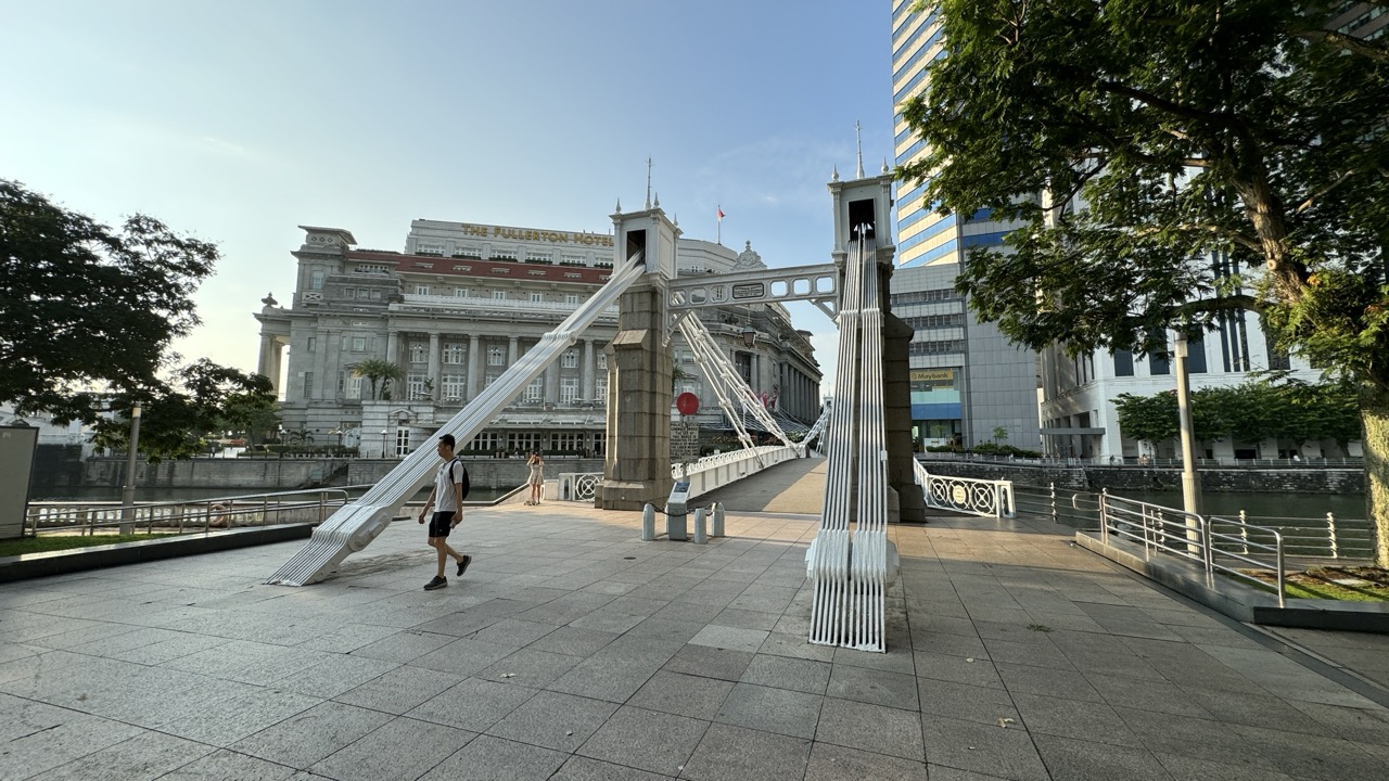
Cavenagh Bridge dates to 1869. The National Heritage Board describes it as the oldest surviving suspension bridge over the Singapore River and explains the use of the Ordish–Lefeuvre system. A casual visitor can begin with the silhouette. Look for the points where the structure rises over the deck and the metal lines that connect one part to another. Compare that pattern with Elgin’s more solid concrete form.
Check for the old restrictions displayed at the bridge ends and look for the crest or the manufacturer’s markings where visible. These are small details that tell you what the crossing was intended to carry and who made it. The historical restrictions are interesting objects to read. Follow current signs for present-day access and use.
The bridge linked the area around Commercial Square, now Raffles Place, with the government quarter across the river. Stand on the bank and identify one landmark on each side. The contrast between the older Civic District frontage and the present financial district gives the crossing a clear purpose in the route. Even a visitor unfamiliar with Singapore can see how short the crossing is relative to the areas it links.
Cross once if it suits the itinerary
Cavenagh is an easy point to consider changing banks. If you want the Empress Place finish, choose a crossing direction that brings you to that side or stay there when you reach it. If you are heading back through Raffles Place, keep the south-bank approach in mind. Look at the full route before crossing just for a photograph and then needing to go back immediately.
When the bridge is busy, a viewpoint at either end can be enough. Give people room to walk through and keep the group away from any bottleneck. The shape is often easier to appreciate from the riverside than from the middle of the deck. A view from the bank is also useful for anyone who wants to avoid standing on a busy crossing.
A family can stop for one quick comparison: which looks more open, Cavenagh or Elgin? Ask a child to explain their answer by naming a visible feature. Adults can look up the material and construction details later. This gives both bridges a distinct place in the walk and keeps the visit enjoyable at a slow pace.
Anderson Bridge and the river mouth
Compare the steel arches with the earlier crossings
Anderson Bridge opened in the early twentieth century. The National Heritage Board’s collection record places completion in 1910, and its bridge guide discusses the use of steel in the structure. The crossing helped relieve traffic on Cavenagh Bridge. Stand back at a suitable public approach and look at the repeated arches. Try to see how the metal members form a pattern across the span rather than focusing on a single decorative detail.
The approach gives a view of the bridge near the river mouth and the city around it. Empress Place is on one side and the Collyer Quay area on the other. Look back towards the earlier part of the route if the view allows. The river is a short stretch on a map, but the bridges connect different streets and activities. The final stop helps put those differences in a wider setting.
URA describes the pedestrianisation of Anderson Bridge and the adjacent stretch as part of changes in the Civic District. Check current access and event signs for your visit. Pedestrian space can still have event barriers or temporary diversions. Use the public routes available on the day and treat the river approach as a complete final stop if a crossing would add unnecessary distance.
Choose a finish near Empress Place or Raffles Place
On the Civic District side, you can finish with the exterior of Victoria Theatre and Concert Hall or with a booked visit to a nearby museum. Keep the clock tower as a landmark if friends are joining at the end. Check the exact museum entrance and programme if it is part of the day. The bridges walk is complete before you enter an attraction.
If you finish on the financial district side, follow the current pedestrian route to Raffles Place or your next stop. Take care at road crossings and let everyone check the return plan before separating. A companion who is travelling on a different line may prefer another station or bus. End at a convenient location for the group rather than retracing the entire walk.
Anderson can also be the first stop on a reverse version. Start near Empress Place, see Anderson and Cavenagh, then decide whether to walk towards Elgin and Clarke Quay. That direction is useful if you have a morning activity at the river mouth or want to end at a meal near Boat Quay or Clarke Quay.
Three materials and one useful family activity
Compare iron, steel and reinforced concrete
Use the three bridges as a simple timeline. NHB highlights cast iron at Cavenagh, steel at Anderson and reinforced concrete at Elgin. These materials can appear together with other construction details. For a first walk, focus on the overall structure rather than trying to identify every surface by colour or texture. The official guide can explain details that are hard to see from the public path.
Take one broad picture of each bridge, from a similar angle where possible. At home, arrange them by construction date. Which looks lightest? Which has the most prominent arch? Which leaves more of the view through the structure? Appearance alone cannot tell you the load a bridge carries. It can help you notice how each design meets the river and makes a place for people to pass.
An older student can then ask what conditions shaped the designs. Think about traffic, the space available for a crossing, construction methods and the needs of boats or the riverfront. Use NHB’s description to check which factors are documented for a particular bridge. This is a better way to use the outing for schoolwork than writing down every plaque without examining the places themselves.
Use a second view to check a first impression
Choose one bridge and give the group thirty seconds to look from the bank before taking any photographs. Ask each person to describe a feature. Then move to another public viewpoint and see whether the same feature is still visible. A detail can vanish from one angle and become prominent from another. A child can see why a single picture does not tell the whole story.
If you want a small activity for visitors, give them a choice between a shape, a sign and a river view. Ask them to collect one example of each across the three stops. Avoid giving every person a long list. The activity works when it makes them look at the actual bridge and notice one thing they would otherwise walk past.
At the finish, compare the observations by bridge name. Someone might remember the old sign at Cavenagh while another remembers Elgin’s concrete arch. Use the heritage page to check anything you are unsure about. An outing with three accurate descriptions is more useful than a rushed walk that leaves the bridges mixed up.
What to look for on each bank
Read the Civic District side
From the bank near Empress Place, look at the path from the river towards the public buildings. Notice where a bridge brings people to a doorway, open space or continuation of a street. Cavenagh’s link to the historic government quarter makes more sense when you see where people can go after stepping off the bridge. A photo that includes a short piece of the bank can show more about the crossing than a close view of the structure alone.
The Civic District bank also gives you a chance to look back towards the commercial side. Compare the riverfront with the taller buildings behind it. Ask which buildings would be useful landmarks for a person walking without a map. A recognisable roof or tower can help connect the river to the larger city. Stay on the public path and use wider areas for group stops.
If you want to include a museum, this side offers an easy way to end the outdoor route near your next activity. Check the actual entrance and time first. You can see the two nearby bridges early and reserve Elgin for a different visit if a booking makes the morning short.
Read the Boat Quay and Raffles Place side
From the other bank, look at the relationship between the river path, the street and the buildings rising behind it. A crossing that seems to lead straight to one landmark from the north bank can open onto a different network of streets once you cross. Choose a moment to look back. That gives you a better idea of why a bridge became such a useful landmark in its own right.
Along Boat Quay, allow for ordinary riverfront activity as well as sightseeing. Choose a suitable place to stop, especially when people are moving between venues. If you want a longer conversation about the bridges, use a quiet area with room for the group rather than stopping where a path narrows. A shorter pause at each bridge can leave more time to see the river as a whole.
Try a route with just one crossing
If the group wants the experience of crossing without repeatedly changing banks, choose one bridge for that part of the day. Cavenagh is a useful choice when you want to compare the view from both ends and then continue to Empress Place. For a finish towards Raffles Place, choose a route that brings you to the appropriate bank at the end. Keep current access signs in mind.
On the chosen crossing, look upstream and downstream only where there is room. Note one landmark in each direction and identify the next stop when you reach the other side. Then keep moving along the bank that fits your plan. This gives the outing a sense of direction without making the route longer simply to cross every bridge.
Heat, rain and practical access
Allow enough time for pauses and crossings
A map can make the bridges look close together, but time is also spent at crossings, reading signs and taking photos. Plan about an hour to 90 minutes for the main route if you want to take it at an easy pace. Give yourself longer for a group with young children or anyone who needs regular rest. Use a shorter version if the group has already been walking elsewhere.
Bring water and choose a cooler part of the day when practical. Some stretches are exposed. If the weather changes, use a nearby indoor destination with confirmed opening arrangements or head to the train. The two-bridge version works well as a shortened outing. If you start at Elgin, you can also finish after Cavenagh and leave Anderson for a future visit.
For a stroller or wheelchair, check station lifts and the street approaches you intend to use. Some waterfront sections can be busy or involve changes of level. Pick a route based on the current public path, including any diversions. If you need a continuous step-free connection, confirm the approach in advance and give yourself time to take a different route if needed.
Make the route easy to split
Choose an agreed finish near a station or venue with a clear address. A companion who wants a longer photography stop can take their time while others head for a seat. A family with younger children can share the first two stops and meet another adult at the last one. Keep the arrangement simple and leave room for a change in weather.
If you are making a museum booking, count backwards from the entrance time and set the point at which the outdoor walk ends. A trip can include the three bridges and a museum when the group has enough time, but the walking distance is only part of the schedule. Ticket checks, toilets and rest stops need space too.
On an evening visit, use public well-used approaches and check your return train. The scenery will look different under artificial lighting, and some details may be easier to see in daylight. Choose one or two features for the evening route and return in daylight if you want to compare the details on the older bridges.
For a group planning a school or photography visit, agree which bridge is the main subject before you set out. If the day is cut short, visit that one first or make it the middle stop with a clear route back. A reader interested in engineering can compare the materials. A reader interested in the history of trade can spend more time looking at the connection between the two banks. The three bridges are close enough to combine, and each can support a short visit on its own.
Two itineraries you can use on the day
The shortest useful route
Start at Empress Place, look at Anderson Bridge from a public approach and then visit Cavenagh. You get one large steel structure and one earlier metal crossing within a compact area. Finish by the river or near a chosen indoor attraction. Tell the group there are two bridges and a clear finish, so everyone knows what to expect.
This is also the best version for visitors who mainly want a photograph and a short introduction to the Civic District. Take one view of the river and one of a bridge in its setting. Use a convenient station afterwards. You can return another time for Elgin without repeating the same route from the same direction.
The fuller route from Clarke Quay
Start with Elgin, walk downstream to Cavenagh and end at Anderson. Look at each bridge from the bank before crossing any of them. Give the group time to pause at one comfortable place along the river. Choose the bank for your finish and the nearest suitable train after the last stop. The route should answer one practical question at every stage: what can we see here and where do we go next?
For visitors arriving separately, send the first bridge, the expected timing and the last landmark. If someone misses the start, they can go directly to Cavenagh or Empress Place. This works well for a mixed group because the landmarks are specific and the outing still makes sense when someone joins for only one section.
Frequently asked questions
Are the Singapore River bridges free to visit?
Yes. This is a public outdoor walk. Transport, food and any museum or performance you add have separate costs.
Which bridge should I start at?
Start at Elgin if coming from Clarke Quay. Start at Anderson or Cavenagh for the shorter Empress Place version.
Which is the oldest surviving bridge of the three?
Cavenagh Bridge dates to 1869. The site of Elgin Bridge has a longer history of crossings, while the present Elgin Bridge was completed in 1929.
Do I need to cross every bridge?
No. Start with a view from the bank and cross only where it fits the route and current public access.
Where should I finish?
Empress Place is convenient for the Civic District. Raffles Place works for a finish on the financial district side.
What if a route is affected by an event?
Follow current signs and use an open riverside approach or finish at the previous bridge. The walk can be shortened without losing its main idea.


