
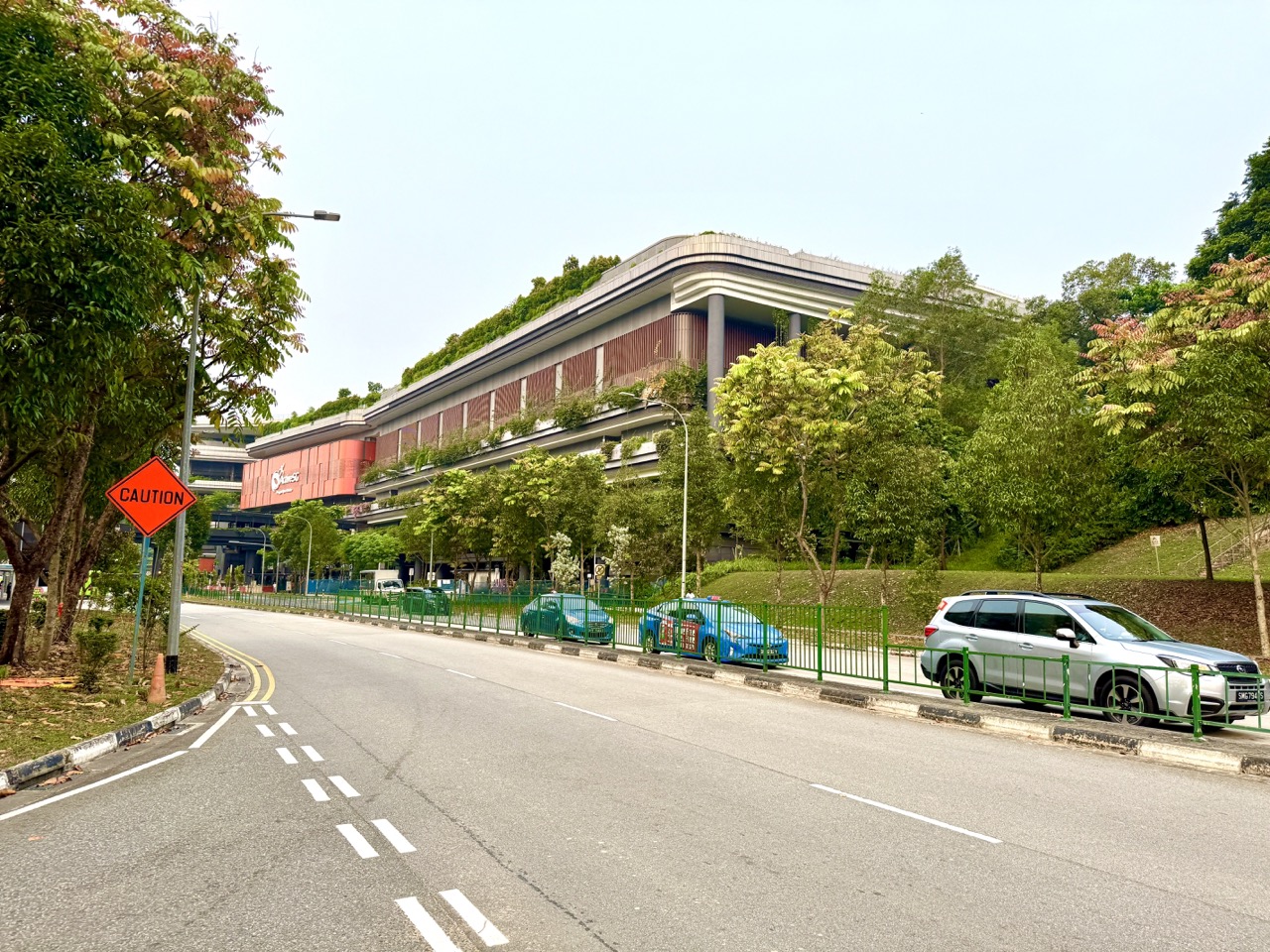
ActiveSG Punggol Sport Centre at 11 Sentul Crescent offers an unusually clear local example of Geography: a public sports development is placed beside Punggol Waterway, near SAFRA Punggol, One Punggol, and Sam Kee LRT (PW1), connecting recreation with transport, homes, green space and the waterfront. The complex began selected public operations on 27 October 2026, with a formal opening announced for 22 November 2026. Sport Singapore’s Sports Facilities Master Plan describes the regional centre as a facility intended to integrate with Punggol’s waterways and SAFRA clubhouse. That makes it useful for studying how land use, accessibility and environmental setting shape a neighbourhood. It does not mean every advertised pool or stadium area is already available for public entry; always check the actual facility and date at MyActiveSG+.
Parents and students can learn Geography here without taking measurements inside closed sports facilities. On an appropriate public route, compare the location of the LRT station, bus stops, pedestrian crossings, waterway paths and sports entrances. Record how people can reach the area, whether a path feels exposed to sun, where shared walkers and cyclists may need to slow down, and how the built environment relates to water and greenery. NParks identifies the Punggol Waterway Park Connector as an 8.4 km route, while URA’s Master Plan 2025 discusses North-East green links and leisure spaces. A responsible student uses these public sources, observes only where access is permitted and explains what the evidence actually shows—rather than guessing that a picturesque photo proves a facility is universally accessible or sustainably operated.
- Main place: Punggol Sport Centre, 11 Sentul Crescent; note nearby Sam Kee LRT, One Punggol, SAFRA Punggol and Punggol Waterway.
- Geography concepts: place, space, land use, accessibility, human–environment relationships, scale, sustainability and urban planning.
- Official planning context: Sport Singapore’s Sports Facilities Master Plan and URA’s North-East recreation plan.
- Waterway context: NParks’ 8.4 km Punggol Waterway Park Connector is a route network, not the distance every visitor must walk.
- Safe inquiry: observe from permitted public spaces; never cross closures, obstruct access, photograph strangers without permission or collect personal details.
- Transport comparison: map pedestrian, LRT, bus and cycling links without inventing exact travel times.
- Fieldwork method: ask a question, define what can be observed, record a small dataset, analyse limitations, explain and reflect.
- Important caution: renderings and future facility plans are not evidence of current public opening.
- For parents: adapt questions to Primary or Secondary level instead of turning a family outing into an assessment.
- This guide: worked inquiry examples, urban geography, waterway stewardship, accessibility, land-use trade-offs and four weeks of local learning.
Definition lock: what does it mean to learn Geography here?
Geography studies places, environments, patterns and the relationships between people and the world around them. At a sports centre, the inquiry is not just “What buildings are nearby?” It asks why recreation has been located at this site, how users can reach it, how different spaces connect and which benefits or trade-offs follow. The place becomes a case study rather than a sightseeing destination.
A student may initially see an attractive building beside a canal. A more thoughtful observer notices the LRT, pedestrian paths, road crossings, park connector, neighbouring community buildings and the relative location of homes. These observations create questions about movement and public access.
Good Geography does not require the student to know every answer immediately. It requires a sensible question, trustworthy information and a distinction between observation and inference. The location invites inquiry; evidence makes the explanation credible.

Why the Sports Facilities Master Plan is relevant
Sport Singapore’s Sports Facilities Master Plan describes efforts to make sport more accessible by developing or rejuvenating facilities across Singapore. It specifically identifies a Punggol Regional Sport Centre intended to host a wider range of sports and events, integrate with the waterways and sit alongside the SAFRA clubhouse.
That statement helps answer the “why here?” question at a broad planning level. The location brings different recreational functions into one area rather than distributing every facility randomly around the town. It can support people who combine sport with a trip to nearby community amenities.
The statement does not establish actual visitor numbers, congestion levels or environmental performance. Those claims need separate evidence. A planning intention and a measured outcome are different things. Students should practise writing both without confusing them.
The October and November opening dates matter
On 27 October 2026, Punggol Sport Centre began a soft launch that included public gym access and selected badminton, pickleball, tennis and table-tennis bookings, according to contemporary reports. A formal opening was announced for 22 November 2026. The published descriptions also mentioned facilities whose public access was not yet available in late October.
For geographical inquiry, this is an excellent lesson about time. A map may show an entire completed sports development while individual amenities are opening in stages. A fieldwork report should date its observations and say whether it is describing a planned space, a completed building or a publicly operating service.
A student’s caption might read, “Exterior of Punggol Sport Centre, October 2026; availability of individual facilities must be verified separately.” That is more accurate than “All facilities open,” which could be false.
The geography of a waterway location
Punggol Waterway is not merely a scenic backdrop. The park connector, water frontage and surrounding paths shape how people experience the neighbourhood. NParks explains that the waterway increases water frontage and provides green space alongside a track for walking, cycling and other leisure activities.
A visitor might use a public path to observe the relationship between water, vegetation, seating, shade and activity. The questions can include where people stop, whether seating is protected from sun or rain, and how the built edge relates to open space. Do not interpret one short observation as a complete ecological study.
A waterway environment also requires safety and respect. Barriers, water edges and slippery surfaces are not places to climb for a photograph or an imagined science experiment. Fieldwork should happen within the designated public route.
Land use: a sports centre is one piece of a town
Land use describes what land is used for: housing, transport, recreation, schools, commercial activity, infrastructure or green space. Around Sentul Crescent, the sports development exists near the community hub, SAFRA, rail and pedestrian links, as well as housing elsewhere in Punggol.
Ask a learner to identify categories on a publicly available map before travelling. Then compare the map with permitted observations. Does the area mainly contain large public buildings? Are different activities within easy walking reach? Do roads or transport routes separate spaces?
Use categories carefully. A building can combine functions, and a green roof does not make the whole development a public park. Land-use mapping improves when the student defines what each colour means and records mixed uses honestly.
Why mixed-use neighbourhoods can be convenient
When sports, community services and transport are near one another, a household may combine several journeys. One parent might accompany a child to a sports lesson, while another member visits a different public amenity. The convenience depends on opening hours, accessibility, weather, waiting and the family’s actual needs.
That last qualification is essential. Proximity on a map does not guarantee that a resident can easily reach the site. A route might have steps, temporary closures or a long road crossing. A family living nearby but travelling with a stroller may use a different path from a fast-moving adult.
Geography asks whether the planned convenience is experienced by different groups. Good fieldwork recognises the gap between abstract distance and lived journey.
Map scale: straight-line distance is not travel distance
Suppose a student measures the direct line between two map pins and finds a short distance. The real pedestrian route may curve around buildings, cross at traffic lights or follow designated access points. The two distances answer different questions. A straight line is useful for some map tasks but should not be reported as a guaranteed walking route.
A learner can draw the actual permitted path using a publicly accessible map and describe where it differs from the direct line. If using a printed map, read the scale carefully. A scale of 1:10,000 means one centimetre on paper represents 100 metres on the ground, assuming the map has not been resized.
Do not invent path lengths just to complete a worksheet. Real map scale should be checked against the version being used.
Sam Kee LRT as an accessibility clue
Sam Kee PW1 on the Punggol LRT West Loop is a nearby public transport link. Visitors coming by the North East Line generally transfer at Punggol before reaching the West Loop. This makes the Sport Centre reachable without private vehicles for some residents, although individual journey complexity differs.
A student can compare which neighbourhoods have a direct rail route, which require interchange and which may be better served by bus. The comparison should use current operator information, not an old estimate of train frequency. For older adults or people with mobility needs, access includes lifts, crossings and step-free routes.
Transport access is a system rather than a dot on a map. The existence of a station does not prove that every user experiences the final journey equally.

Reading bus-stop codes as geographic evidence
Nearby Sentul Crescent stops include Opp One Punggol (65481) and One Punggol (65489). These stop identifiers help distinguish opposite-direction services even when the names are similar. A student can locate the stops on a transit map and ask why bus routes serve different sides of the road.
Do not confuse the route number with the stop code. A bus may travel along a loop with differently labelled direction variants. The careful geographer identifies the relevant service, stop and intended travel direction rather than merely copying a list of numbers.
A map-based inquiry can compare transport modes without standing in the road or photographing commuters. Use official published information and conduct any observation from a safe public area.
Walkability is more than metres
Walkability refers to how practical and comfortable a place is to reach on foot. Distance matters, but so do footpath condition, continuity, crossings, exposure to weather, lighting, crowding and the needs of users. Around a major sports development, these factors may change across the day or during construction work.
A family could assess one safe public route with a simple observation sheet. Identify continuous sidewalks, legal crossings, potential rest areas and places where mixed pedestrians and cyclists need to be especially careful. Avoid making a formal accessibility claim without knowing the required standard and full route.
A three-minute walk estimate may suit one adult yet be unsuitable for a wheelchair user or a family with young children. The comparison improves when the student explains whose journey is being described.
Accessibility should not be guessed from photographs
A photograph of a modern entrance can look accessible while failing to show a kerb ramp, narrow crossing, lift outage or a temporary obstruction. Conversely, a visible set of stairs does not mean there is no alternative step-free route. Students must distinguish what an image actually records from what it does not show.
If accessibility is central to a family’s decision, contact the responsible operator about the exact entrance and facility. Do not ask a person to publicly disclose private medical details to justify that request. The geographical question is about the route and barriers, not a judgement about someone’s abilities.
A respectful inquiry asks, “Can the entire journey be completed using step-free public paths?” It should accept “not yet verified” when evidence is incomplete.
Shared paths and competing needs
Punggol Waterway paths may be used by walkers, joggers, cyclists and people with mobility devices. Shared spaces can connect residents to recreation, but they also require courteous behaviour and appropriate rules. A path that looks quiet during a morning photograph may be crowded at school dismissal.
A geography learner can list different user needs without ranking them as more or less deserving. A cyclist may want an efficient through-route; an older walker may value a slower, comfortable path; a parent with a stroller may need a continuous surface. The challenge is designing and using infrastructure that supports these purposes safely.
Do not run an experiment that deliberately blocks a path or tests how strangers react. Observation should be non-intrusive.
Shade is a microclimate question
Two paths of similar length can feel very different under Singapore’s sun. Trees, covered walkways and building shade may change direct exposure, while open paved areas can feel hotter at certain times. A student can observe shade patterns at safe points, taking note of the time and weather.
However, a single perception such as “this spot feels cooler” is not a formal temperature measurement. To make a scientific claim about degrees, suitable equipment and a consistent method are required. The geographical question may simply be how shade affects comfort and route choice.
Parents should follow heat-stress advisories and avoid turning an outdoor inquiry into a long exposure during difficult conditions. A short study from a safe location is sufficient.
Rain changes the meaning of a convenient route
A path that is pleasant in dry conditions may include exposed sections, wet surfaces or drainage during heavy rain. Shelter is useful, but being under a roof does not eliminate every risk during lightning. A geographical inquiry can compare the presence of covered segments from safe observations without deliberately walking through dangerous weather.
Record which parts of the route have built shelter and where crossings are exposed. Ask how the route might change when a traveller carries sports equipment or accompanies children. Do not claim that a sheltered sports court is always open during storms; operator closures are a separate matter.
The point is to understand how environment and infrastructure interact. Weather is not merely a background detail in urban mobility.
The park connector is not a sports-centre running track
NParks lists the Punggol Waterway Park Connector as 8.4 km and describes it as a promenade route along both sides of the waterway. This is a public network relevant to neighbourhood recreation. It should not be confused with an ActiveSG stadium running track or with the length of every individual visitor’s walk.
A student can identify where the connector travels and what other parks or routes it approaches. If planning an outing, choose a segment that fits ability and current conditions, not the full 8.4 km automatically. The number describes the published route, not an obligation to complete it.
This distinction demonstrates why units and geographic definitions matter. A route’s overall length is not a personalised exercise prescription.
How the URA Master Plan frames North-East recreation
URA’s 2025 Master Plan materials describe a North-East region in which parks, waterways and recreational destinations are linked together. The Fun by the Water, Play Near Home page refers to the 26 km North-Eastern Riverine Loop connecting Punggol Park, Punggol Point Park, Punggol Waterway Park and Sengkang Riverside Park.
A student should recognise that this is a planning and network perspective, not a claim that a person visiting one sports centre will walk the entire loop. It demonstrates a regional scale: Punggol is connected to other north-eastern neighbourhoods through green links.
Geography becomes richer when students move between scales, from one entrance and street crossing to the wider network of parks and destinations.
Green space creates both benefits and responsibilities
Greenery can provide visual enjoyment, biodiversity habitat and a different environment from densely built streets. But a park landscape also needs maintenance, appropriate use and protection from damage. NParks describes Punggol Waterway as offering a green respite and an opportunity to observe birds.

Visitors should remain on permitted paths, avoid disturbing wildlife and leave the area clean. A student cannot assume that every planted area is open for recreational use or that climbing a slope will produce useful data. Public space has ecological and safety considerations beyond the family’s activity.
Stewardship is a meaningful geographical theme. People are not simply consumers of parks; their behaviour helps determine whether shared spaces remain welcoming and functional.
Sustainability claims require evidence
A new building may display planters, terraces and architectural features that look environmentally friendly. Those observations can support a description of its appearance, but not a claim that it has a particular energy rating, water efficiency or carbon footprint. Such claims need verifiable technical records.
A student might ask whether building greenery changes perceived comfort or how a shared sports location could reduce certain journeys. These are hypotheses, not guaranteed measured benefits. For stronger conclusions, identify the necessary evidence and its limitations.
This is an important research skill: distinguish design intention, physical appearance and verified environmental performance. A beautiful green roof is not itself a complete sustainability audit.
Public sport and the question of fair access
The Sports Facilities Master Plan aims to improve community opportunities for participation. A geographical inquiry can ask how location, transport and booking systems influence access. Residents living near Sam Kee may experience different travel burdens from households in another estate; people who work shifts may prefer other times from school families.
Avoid inventing demographic conclusions or personal income data from a short visit. Use public policy and transit records for broader facts, then describe limited local observations honestly. If surveying residents, consider appropriate consent, safeguarding and data protection rather than collecting private information casually.
A public facility has a physical geography and an administrative geography: its actual service areas are shaped by location, operating hours, eligibility and reservations.
Fieldwork question one: how do people reach the site?
A beginner-friendly inquiry asks: “Which public transport and pedestrian routes connect the Sport Centre to nearby community spaces?” Start with a current map and identify the LRT station and relevant bus stops. Plan a legal public walk to observe crossings, signs and path continuity.
The student can draw a simple route diagram and note features, not people. A useful dataset might be a list of route choices and whether they involve a transfer or designated road crossing. Exact journey times should be measured carefully if included, with method and conditions stated.
End by explaining one advantage and one limitation of the observed route. This is better Geography than declaring a location perfectly connected without looking beyond the map pin.
Fieldwork question two: where are the different land uses?
An older student can classify surroundings into sports, community, transport, waterway, commercial and other categories, using verified map information and appropriate observation. The important step is defining each category before assigning it.
A community building may contain different functions, so forcing every whole building into one simplistic category can lose information. The student can record mixed use where supported. Use public maps rather than entering private premises or taking images of people without permission.
After classification, ask whether certain uses cluster near one another and why that might be beneficial. Offer a cautious explanation of convenience and shared infrastructure rather than assuming that every household experiences the cluster identically.
Fieldwork question three: where does shelter appear?
A short safe inquiry could map which portions of an approved pedestrian approach are under a roof or significant tree shade at a particular time. The student marks observations on a simple sketch map and notes the date and weather.
Do not walk during lightning, heavy rain or high heat stress to force completion of the exercise. It is acceptable to postpone or use publicly available images with clear source labels. If the student uses imagery, it should be described as dated evidence rather than current live conditions.
The conclusion might be that a route has both sheltered and exposed sections. A useful limitation would explain that shade changes with time of day and that temporary works may alter the route.
How to make a trustworthy observation table
A small table could include a feature, location description, observation, date and uncertainty. For example: “Designated crossing near bus stop: present on the observed route; crossing conditions may change during roadworks.” This is more useful than a vague “easy to reach.”
The table should avoid personal data, photographs of children and invented statistics. It is not necessary to count how many visitors belong to different income or health categories. Those facts cannot be reliably inferred from appearance.
Ask the learner to distinguish “I saw” from “I think” and “The official page states.” Three kinds of statements can appear in the same report, but they need different evidence.
Primary-school approach: draw, label and explain
For younger learners, begin with a simple labelled sketch rather than a complex GIS analysis. Ask them to show the sports centre, nearby waterway, station and a legal pedestrian route, using an official map as a reference. Then ask why a family might find the location convenient.
Keep the activity short and do not require a child to collect measurements in traffic. They can discuss shelter, greenery or the difference between a river and a sports facility. Encourage complete sentences with correct place names.
A successful Primary task is one in which the child can explain what two locations are and how they connect. Accuracy matters more than drawing an elaborate architectural picture.
Lower-secondary approach: geographic inquiry
A lower-secondary student can formulate a focused question, choose a method, gather a small dataset and explain limitations. The site offers accessible themes such as route choice, land-use mix and pedestrian shelter. MOE Geography materials emphasise inquiry, interpretation and the relationship between people and environments.
The student should avoid a question too broad to answer, such as “Is Punggol sustainable?” Instead ask, “What types of land use are visible along one permitted approach to the Sports Centre?” Define the boundary and data collection rules before starting.
The conclusion should not generalise beyond the observed area. A carefully limited answer is more convincing than sweeping claims about all Singapore neighbourhoods.
Upper-secondary approach: evaluating trade-offs
Older students can discuss how planning choices balance limited land, recreation, transport infrastructure, the waterway environment and neighbourhood services. A sports development may improve access for some users while also creating pressures such as traffic or demand for nearby paths. These are possible issues to investigate, not established measurements of local congestion.
Use official plans as evidence of policy aims, then ask what additional data would be needed to assess outcomes. For example, verifying vehicle traffic impact could require authorised counts, appropriate comparison periods and information beyond one family’s observation.
This builds evaluation skills: weighing potential benefits, recognising constraints and resisting unsupported certainty. Students should state both the strengths and the limits of their evidence.
Reading an artist’s impression critically
Public planning websites sometimes show architectural renderings of future pools, rooftop spaces and gardens. These illustrations help explain design intent, but they are not photographs of current public operations. A student should label the image type and date.
Compare an actual permitted exterior photograph from October 2026 with an earlier rendering. Identify observable similarities and differences without declaring that planned amenities are already accessible. Even if the building looks complete, the actual booking portal governs public use.
This habit transfers to news literacy. A compelling visual can be true as a design proposal while misleading as evidence of present-day availability.
Why photograph captions should include dates
A photograph of Punggol Sport Centre in late October 2026 captures a moment in a changing development. Construction barriers, path arrangements and opening notices may look different by 2027. A responsible caption identifies the place and approximate date rather than pretending the image is live.
The same rule applies to waterway photographs. Seasonal weather, lighting and human activity can change. A photo showing a quiet path at one time does not prove that the route is never crowded or always safe for cyclists.
Good Geography uses visual evidence with context. Accurate captions prevent an image from communicating more than it can support.
A parent-child outing with no court booking
A family can study the geography of the area from permitted public walkways without reserving any ActiveSG court. They might identify Sam Kee on a map, follow a suitable public route toward the waterway and talk about why transport and recreation have been placed near one another.
This is an educational outing, not a claim that the family may enter closed sports halls to gather notes. The adult should choose a safe route, respect shared walkers and cyclists, and keep the activity appropriate to the child’s energy and weather.
The child might return home with a simple sketch map and three sentences: “Where is the sport centre? How can people reach it? What do I notice about the waterway?” That is enough for a meaningful beginner inquiry.
A student scenario: deciding between train and bus
Two fictional students live in different parts of the North-East. One has a convenient North East Line connection and can transfer to Sam Kee; another has a suitable direct bus. The geographical task is to compare their journeys using actual current routes, number of transfers and pedestrian approaches.
Do not invent travel times for unnamed homes. Instead let the learner write conditional statements: “If the direct bus serves the correct direction near my origin, it may reduce transfers.” Then identify what information a real comparison would require.
This teaches that accessibility depends on origin and user circumstances, not simply the distance from a landmark to the nearest station.
A student scenario: the same route in different weather
A student imagines reaching Punggol Sport Centre on a dry afternoon and during heavy rain. They use an existing route map to identify exposed areas and sheltered alternatives, but do not deliberately venture into dangerous weather. The question is how physical conditions affect practical accessibility.
The student might conclude that a route’s convenience changes with weather, equipment carried and family mobility needs. The conclusion remains conditional because they have not measured exact effects for every user.
This is a responsible example of human–environment thinking. The environment shapes choices, while appropriate built infrastructure and personal decisions can reduce certain difficulties.
A student scenario: a waterfront with different users
A learner observes from a safe public place that walkers, cyclists and people resting share the waterway environment. They consider why a park connector must accommodate different movement speeds and how courtesy can help prevent conflict.
The task does not involve recording strangers’ identities or assigning demographic categories from appearance. It describes types of activity visible in a specific period and acknowledges that another time of day could show a different pattern.
The student can link this observation to a larger planning challenge: a recreational corridor supports several purposes at once. Designing and using shared space requires balancing those purposes rather than assuming one group has exclusive rights.
What geography cannot establish from a brief visit
A twenty-minute outing cannot prove that the whole sports centre is environmentally sustainable, that all facilities are accessible, or that Punggol’s entire population uses the space equally. Such claims require broader, carefully collected data and appropriate definitions.
A student should identify evidence limitations explicitly: one route, one time, no private access, possible temporary construction, and no reliable demographic survey. This honesty strengthens the report rather than weakening it.
Geographical learning is not about producing a spectacular conclusion. It is about asking an answerable question and knowing how much confidence the evidence deserves.
Four-week Punggol geography learning sequence
In week one, use official maps to locate the sports centre, station, bus stops and waterway. In week two, make one short safe observation along a permitted public route and take notes without photographing strangers. In week three, organise observations into a simple labelled diagram or table and compare them with SportSG, NParks and URA sources. In week four, write a short explanation with one benefit, one limitation and one unanswered question.
This sequence works even if a facility is not publicly open or the weather prevents a field visit. Desk-based research can replace an unsafe trip, provided sources and dates are labelled. Do not treat a school-style inquiry as permission to block paths or use restricted areas.
The aim is to develop careful observation and reasoning. The city becomes a learning resource without turning the family’s recreation into a test.
Frequently asked questions
Where is ActiveSG Punggol Sport Centre? At 11 Sentul Crescent, Singapore 828656, beside SAFRA Punggol and near Sam Kee LRT.
What is the main Geography topic here? The relationship between land use, transport accessibility, recreation, the waterway environment and neighbourhood planning.
Is Punggol Waterway Park Connector really 8.4 km? NParks lists its Punggol Waterway connector route as 8.4 km. That is the published route length, not every individual’s journey to the sports centre.
Does being beside an LRT station prove full accessibility? No. Step-free continuity, crossings, entrances, operating conditions and different users’ needs must be checked.
Does a green-looking building prove low emissions? No. Appearance alone cannot establish measured energy, water or carbon performance.
Can students enter a closed pool for fieldwork? No. Follow all public-access restrictions and operator rules.
Should children photograph sport-centre users for a survey? Do not assume that is permitted. Avoid identifiable personal data and comply with venue photography requirements.
What can a Primary child do without booking sport? Draw a labelled sketch map, identify public transport links and explain one observed land-use relationship from a safe public route.
What can a Secondary student investigate? An answerable geographic inquiry such as pedestrian route continuity, land-use mix or shade along one appropriately defined public path.
Is a rendering the same as an operational photo? No. A rendering depicts design intent or a proposal; a dated photo captures a particular observed moment.
Official sources and your next step
Use Sport Singapore’s Sports Facilities Master Plan, NParks’ Punggol Waterway page, URA’s North-East recreation plan and URA’s recreation planning overview. Current sport access is at MyActiveSG+. For transport logistics, read our Sam Kee LRT and bus directions guide; for sports science, see the movement science guide.
Your next step: choose one question about the sport centre’s location, compare a reliable official map with a safe permitted observation or dated photograph, and explain what the evidence can and cannot show. Accurate, thoughtful Geography begins with one place and one honest question.
Editorial note: Independent local educational guide prepared 1 November 2026. Examples are illustrative, not official MOE fieldwork tasks or authorisation to enter restricted sports areas. Public access and transport information may change.


